Property Record
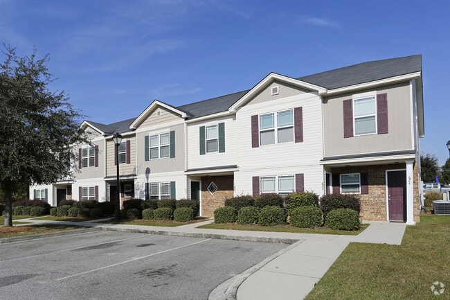
552 E Main St, Statesboro, GA 30461

Property Detail
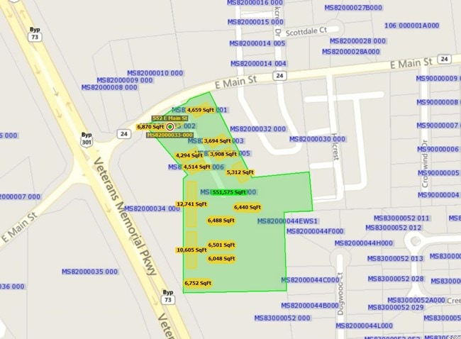
552 E Main St
MS82000033-000
12.73 AC/PAR A&B/THE VILLAGE AT MILL CREEK
Clubslodgesprofessionalassociations
Bulloch
PUD/R4
Georgia
B and X Area of moderate flood hazard, usually the area between the limits of the 100-year and 500-year floods.
12.73 AC
2025
Georgia South Area
2025
Other Market Areas
110604
Statesboro, GA
950 SF
NEARBY LISTINGS FOR SALE OR LEASE
-
-
View all Statesboro listings for sale on LoopNet.com
DEMOGRAPHICS near 552 E Main St
1 mile
3 mile
5 mile
2025 Total Population
4,312
27,456
50,292
2030 Population
4,632
28,853
52,753
Pop Growth 2025-2030
+ 7.42%
+ 5.09%
+ 4.89%
Average Age
36
34
33
2025 Total Households
1,844
10,326
18,816
HH Growth 2025-2030
+ 7.70%
+ 5.84%
+ 5.33%
Median Household Inc
$37,902
$49,402
$49,285
Avg Household Size
2.30
2.30
2.40
2025 Avg HH Vehicles
1.00
2.00
2.00
Median Home Value
$252,955
$229,794
$253,710
Median Year Built
1994
1985
1992
Nearby Places
Map Layers
Map Styles
 Street
 Aerial
Layers
 Traffic
 Biking
Places
Listings with unknown addresses are not visible on the map
- Restaurants
- Banks
- Shops
- Fitness
- Groceries
Nearby Properties
Address
Land Use
TOTAL SIZE
Lot Size
Zoning
Address
Land Use
TOTAL SIZE
Lot Size
Zoning
250,037 SF
30.67 AC
O
Address
Land Use
TOTAL SIZE
Lot Size
Zoning
328,813 SF
2.86 AC
CR
Address
Land Use
TOTAL SIZE
Lot Size
Zoning
1,280 SF
792.45 AC
LI
Address
Land Use
TOTAL SIZE
Lot Size
Zoning
5.54 AC
EXPT
Address
Land Use
TOTAL SIZE
Lot Size
Zoning
41.09 AC
R3/R15
Address
Land Use
TOTAL SIZE
Lot Size
Zoning
146,137 SF
17.78 AC
CR
Address
Land Use
TOTAL SIZE
Lot Size
Zoning
3,659 SF
38.60 AC
R40
Address
Land Use
TOTAL SIZE
Lot Size
Zoning
153.74 AC
R40
Address
Land Use
TOTAL SIZE
Lot Size
Zoning
4,450 SF
26.60 AC
R4
Address
Land Use
TOTAL SIZE
Lot Size
Zoning
190,382 SF
23.53 AC
CR
Address
Land Use
TOTAL SIZE
Lot Size
Zoning
13 AC
R20
Address
Land Use
TOTAL SIZE
Lot Size
Zoning
1,893 SF
10.73 AC
R4
Address
Land Use
TOTAL SIZE
Lot Size
Zoning
61,539 SF
2.50 AC
CR
Address
Land Use
TOTAL SIZE
Lot Size
Zoning
19.41 AC
R10/R15
Address
Land Use
TOTAL SIZE
Lot Size
Zoning
20.77 AC
R15
Address
Land Use
TOTAL SIZE
Lot Size
Zoning
1,668 SF
14.51 AC
R4
Address
Land Use
TOTAL SIZE
Lot Size
Zoning
3,195 SF
22.67 AC
PUD/R4
Address
Land Use
TOTAL SIZE
Lot Size
Zoning
64,614 SF
Address
Land Use
TOTAL SIZE
Lot Size
Zoning
54,062 SF
2.20 AC
CR
Address
Land Use
TOTAL SIZE
Lot Size
Zoning
45,428 SF
8.99 AC
PUD
Address
Land Use
TOTAL SIZE
Lot Size
Zoning
88,014 SF
9.64 AC
CR
Address
Land Use
TOTAL SIZE
Lot Size
Zoning
52.59 AC
HC/R-80
Address
Land Use
TOTAL SIZE
Lot Size
Zoning
58,176 SF
2.10 AC
HOC
Address
Land Use
TOTAL SIZE
Lot Size
Zoning
70,000 SF
12 AC
R4/HOC
Address
Land Use
TOTAL SIZE
Lot Size
Zoning
102,529 SF
20.39 AC
CR
Address
Land Use
TOTAL SIZE
Lot Size
Zoning
76,118 SF
21.89 AC
CR
Address
Land Use
TOTAL SIZE
Lot Size
Zoning
83,803 SF
14.40 AC
CR
Address
Land Use
TOTAL SIZE
Lot Size
Zoning
16,501 SF
1.47 AC
CR
Address
Land Use
TOTAL SIZE
Lot Size
Zoning
29,004 SF
5.39 AC
LI
The World's #1 Commercial Real Estate Marketplace
Connect with us
© 2026 CoStar Group
The information above has been obtained from sources believed reliable. While we do not doubt its accuracy we have not verified it and make no guarantee, warranty or representation about it. It is your responsibility to independently confirm its accuracy and completeness. Any projections, opinions, assumptions, or estimates used are for example only and do not represent the current or future performance of the property. The value of this transaction to you depends on tax and other factors which should be evaluated by your tax, financial, and legal advisors. You and your advisors should conduct a careful, independent investigation of the property to determine to your satisfaction the suitability of the property for your needs.