Property Record
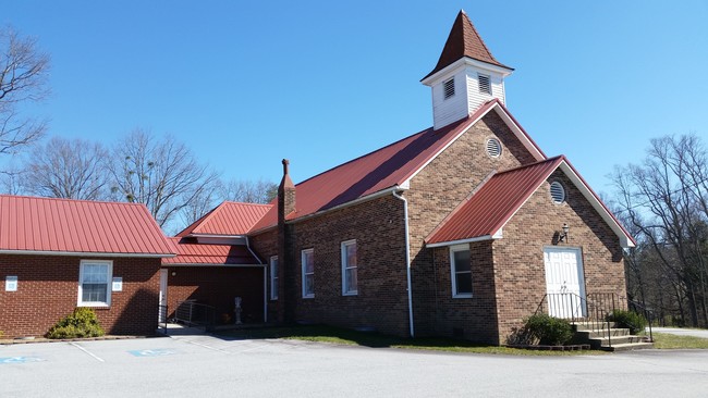
552 Ridge Rd, Hendersonville, NC 28792


Property Detail
552 Ridge Rd
9599347490
RECOMBINATION SURVEY OF 3.74 ACRES
Religious
HENDERSON
10005517~R
North Carolina
B and X Area of moderate flood hazard, usually the area between the limits of the 100-year and 500-year floods.
7490
2025
2.62 AC
2025
Henderson County
930201
Asheville
3,657 SF
Asheville, NC
NEARBY LISTINGS FOR SALE OR LEASE
-
-
View all Hendersonville listings for sale on LoopNet.com
DEMOGRAPHICS near 552 Ridge Rd
1 mile
3 mile
5 mile
2025 Total Population
1,653
13,663
37,676
2030 Population
1,715
14,160
39,147
Pop Growth 2025-2030
+ 3.75%
+ 3.64%
+ 3.90%
Average Age
42
43
43
2025 Total Households
641
5,547
15,532
HH Growth 2025-2030
+ 3.90%
+ 3.75%
+ 4.03%
Median Household Inc
$51,956
$51,339
$51,558
Avg Household Size
2.50
2.40
2.30
2025 Avg HH Vehicles
2.00
2.00
2.00
Median Home Value
$219,375
$279,908
$278,980
Median Year Built
1991
1995
1990
Nearby Places
Map Layers
Map Styles
 Street
 Aerial
Layers
 Traffic
 Biking
Places
Listings with unknown addresses are not visible on the map
- Restaurants
- Banks
- Shops
- Fitness
- Groceries
PUBLIC TRANSPORTATION
AIRPORT
Asheville Regional
Drive
Walk
Distance
Asheville Regional
22 min
14.4 mi
Freight Ports
North Charleston Terminal
Drive
Walk
Distance
North Charleston Terminal
265 min
236.0 mi
SALE & LEASE HISTORY
LISTING DATE
SALE/LEASE

Jun 26, 2019
For Sale
Nearby Properties
Address
Land Use
TOTAL SIZE
Lot Size
Zoning
Address
Land Use
TOTAL SIZE
Lot Size
Zoning
90,601 SF
25.35 AC
9932504~R2
Address
Land Use
TOTAL SIZE
Lot Size
Zoning
90,000 SF
19.59 AC
1004354~R2
Address
Land Use
TOTAL SIZE
Lot Size
Zoning
99,918 SF
12.90 AC
9933125~R2
Address
Land Use
TOTAL SIZE
Lot Size
Zoning
23,960 SF
5.91 AC
1013700~HM
Address
Land Use
TOTAL SIZE
Lot Size
Zoning
90,967 SF
16.21 AC
202693~LC
Address
Land Use
TOTAL SIZE
Lot Size
Zoning
193,280 SF
25.67 AC
201401~I
Address
Land Use
TOTAL SIZE
Lot Size
Zoning
25,750 SF
22.64 AC
200817~CC
Address
Land Use
TOTAL SIZE
Lot Size
Zoning
38,576 SF
5.28 AC
9969932~R2
Address
Land Use
TOTAL SIZE
Lot Size
Zoning
94,440 SF
6.82 AC
1018008~I
Address
Land Use
TOTAL SIZE
Lot Size
Zoning
34,524 SF
9.40 AC
1006365~PR
Address
Land Use
TOTAL SIZE
Lot Size
Zoning
114,100 SF
5.73 AC
202324~I
Address
Land Use
TOTAL SIZE
Lot Size
Zoning
7,249 SF
24.56 AC
1017663~R1
Address
Land Use
TOTAL SIZE
Lot Size
Zoning
1,713 SF
22.64 AC
9926607~R2
Address
Land Use
TOTAL SIZE
Lot Size
Zoning
10,000 SF
8.25 AC
1002933~C-
Address
Land Use
TOTAL SIZE
Lot Size
Zoning
61.16 AC
10008113~I
Address
Land Use
TOTAL SIZE
Lot Size
Zoning
23.77 AC
10009501~I
Address
Land Use
TOTAL SIZE
Lot Size
Zoning
1,065 SF
30.47 AC
200658~R2R
Address
Land Use
TOTAL SIZE
Lot Size
Zoning
8,080 SF
4.97 AC
9932798~CC
Address
Land Use
TOTAL SIZE
Lot Size
Zoning
80,604 SF
15.74 AC
10009918~L
Address
Land Use
TOTAL SIZE
Lot Size
Zoning
720 SF
4.70 AC
1008677~LC
Address
Land Use
TOTAL SIZE
Lot Size
Zoning
3,750 SF
8.26 AC
1012528~I
Address
Land Use
TOTAL SIZE
Lot Size
Zoning
58.30 AC
1012527~R2
Address
Land Use
TOTAL SIZE
Lot Size
Zoning
7,858 SF
13.06 AC
1012713~R1
Address
Land Use
TOTAL SIZE
Lot Size
Zoning
1,200 SF
39.81 AC
1014456~R2
Address
Land Use
TOTAL SIZE
Lot Size
Zoning
5,400 SF
4.19 AC
111283~C-2
Address
Land Use
TOTAL SIZE
Lot Size
Zoning
28,840 SF
6.26 AC
9973830~CC
Address
Land Use
TOTAL SIZE
Lot Size
Zoning
2,404 SF
6.28 AC
9968207~R1
Address
Land Use
TOTAL SIZE
Lot Size
Zoning
20,752 SF
4.88 AC
9933102~LC
Address
Land Use
TOTAL SIZE
Lot Size
Zoning
10,800 SF
5.65 AC
9945584~R2
Address
Land Use
TOTAL SIZE
Lot Size
Zoning
61,250 SF
5.62 AC
9963309~R2
The World's #1 Commercial Real Estate Marketplace
Connect with us
© 2026 CoStar Group
The information above has been obtained from sources believed reliable. While we do not doubt its accuracy we have not verified it and make no guarantee, warranty or representation about it. It is your responsibility to independently confirm its accuracy and completeness. Any projections, opinions, assumptions, or estimates used are for example only and do not represent the current or future performance of the property. The value of this transaction to you depends on tax and other factors which should be evaluated by your tax, financial, and legal advisors. You and your advisors should conduct a careful, independent investigation of the property to determine to your satisfaction the suitability of the property for your needs.