Property Record
552 Treeside Dr, Akron, OH 44313
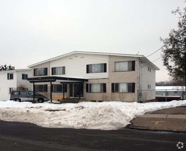
Property Detail
552 Treeside Dr
Akron, OH
PARK HTS EST #8 REALLT LOT 721 ALL
67-26616
Summit
Apartment
Ohio
2023
721
2025
0.28 AC
507101
Northwest Akron
5,629 SF
Cleveland
NEARBY LISTINGS FOR SALE OR LEASE
DEMOGRAPHICS near 552 Treeside Dr
1 mile
3 mile
5 mile
2024 Total Population
9,192
58,721
155,536
2029 Population
9,113
58,615
155,679
Pop Growth 2024-2029
(0.86%)
(0.18%)
+ 0.09%
Average Age
42
42
41
2024 Total Households
4,193
27,379
68,234
HH Growth 2024-2029
(0.86%)
(0.16%)
+ 0.06%
Median Household Inc
$86,588
$70,108
$60,341
Avg Household Size
2.20
2.10
2.10
2024 Avg HH Vehicles
2.00
2.00
2.00
Median Home Value
$201,965
$217,130
$186,262
Median Year Built
1957
1959
1958
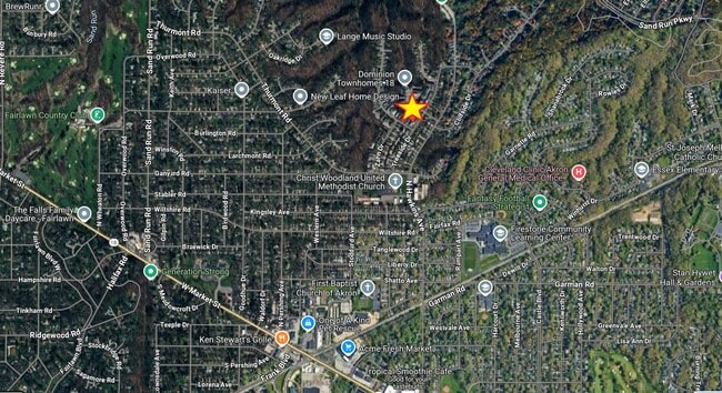
Nearby Places
Map Layers
Map Styles
 Street
 Aerial
Transit
 Traffic
 Biking
Places
Listings with unknown addresses are not visible on the map
- Restaurants
- Banks
- Shops
- Fitness
- Groceries
PUBLIC TRANSPORTATION
COMMUTER RAIL
Big Bend (National Park Scenic Railway - Cuyahoga Valley Scenic Railroad)
Drive
Walk
Distance
Big Bend (National Park Scenic Railway - Cuyahoga Valley Scenic Railroad)
8 min
2.6 mi
Botzum (National Park Scenic Railway - Cuyahoga Valley Scenic Railroad)
Drive
Walk
Distance
Botzum (National Park Scenic Railway - Cuyahoga Valley Scenic Railroad)
11 min
4.7 mi
AIRPORT
Akron-Canton Regional
Drive
Walk
Distance
Akron-Canton Regional
31 min
18.3 mi
Cleveland-Hopkins International
Drive
Walk
Distance
Cleveland-Hopkins International
52 min
34.3 mi
Freight Ports
Port of Toledo
Drive
Walk
Distance
Port of Toledo
155 min
128.8 mi
SALE & LEASE HISTORY
LISTING DATE
SALE/LEASE

Apr 30, 2025
For Sale
Nearby Properties
Address
Land Use
TOTAL SIZE
Lot Size
Zoning
Address
Land Use
TOTAL SIZE
Lot Size
Zoning
245,662 SF
866.66 AC
Address
Land Use
TOTAL SIZE
Lot Size
Zoning
Address
Land Use
TOTAL SIZE
Lot Size
Zoning
282,490 SF
20.76 AC
Address
Land Use
TOTAL SIZE
Lot Size
Zoning
676,403 SF
39.06 AC
Address
Land Use
TOTAL SIZE
Lot Size
Zoning
194,508 SF
30.87 AC
Address
Land Use
TOTAL SIZE
Lot Size
Zoning
91,104 SF
17.30 AC
Address
Land Use
TOTAL SIZE
Lot Size
Zoning
311,093 SF
32.53 AC
Address
Land Use
TOTAL SIZE
Lot Size
Zoning
479,446 SF
6.07 AC
Address
Land Use
TOTAL SIZE
Lot Size
Zoning
192,658 SF
15.34 AC
Address
Land Use
TOTAL SIZE
Lot Size
Zoning
246,312 SF
17.50 AC
Address
Land Use
TOTAL SIZE
Lot Size
Zoning
Address
Land Use
TOTAL SIZE
Lot Size
Zoning
10 AC
Address
Land Use
TOTAL SIZE
Lot Size
Zoning
10.78 AC
Address
Land Use
TOTAL SIZE
Lot Size
Zoning
12.46 AC
Address
Land Use
TOTAL SIZE
Lot Size
Zoning
313,167 SF
18.50 AC
Address
Land Use
TOTAL SIZE
Lot Size
Zoning
43,574 SF
3.67 AC
Address
Land Use
TOTAL SIZE
Lot Size
Zoning
76,560 SF
6.07 AC
Address
Land Use
TOTAL SIZE
Lot Size
Zoning
10.26 AC
Address
Land Use
TOTAL SIZE
Lot Size
Zoning
327,798 SF
116.80 AC
Address
Land Use
TOTAL SIZE
Lot Size
Zoning
58,639 SF
2.29 AC
Address
Land Use
TOTAL SIZE
Lot Size
Zoning
Address
Land Use
TOTAL SIZE
Lot Size
Zoning
Address
Land Use
TOTAL SIZE
Lot Size
Zoning
209,183 SF
36.34 AC
Address
Land Use
TOTAL SIZE
Lot Size
Zoning
121,170 SF
1 AC
Address
Land Use
TOTAL SIZE
Lot Size
Zoning
123,367 SF
8.81 AC
Address
Land Use
TOTAL SIZE
Lot Size
Zoning
105,770 SF
16.40 AC
Address
Land Use
TOTAL SIZE
Lot Size
Zoning
136,381 SF
6.51 AC
Address
Land Use
TOTAL SIZE
Lot Size
Zoning
104,861 SF
2.07 AC
Address
Land Use
TOTAL SIZE
Lot Size
Zoning
63,298 SF
3.99 AC
Address
Land Use
TOTAL SIZE
Lot Size
Zoning
25,296 SF
9.36 AC
The World's #1 Commercial Real Estate Marketplace
Connect with us
© 2026 CoStar Group
The information above has been obtained from sources believed reliable. While we do not doubt its accuracy we have not verified it and make no guarantee, warranty or representation about it. It is your responsibility to independently confirm its accuracy and completeness. Any projections, opinions, assumptions, or estimates used are for example only and do not represent the current or future performance of the property. The value of this transaction to you depends on tax and other factors which should be evaluated by your tax, financial, and legal advisors. You and your advisors should conduct a careful, independent investigation of the property to determine to your satisfaction the suitability of the property for your needs.