Property Record
5520 Adamstown Rd, Adamstown, MD 21710
NEARBY LISTINGS FOR SALE OR LEASE
Property Detail
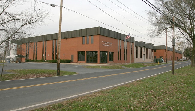
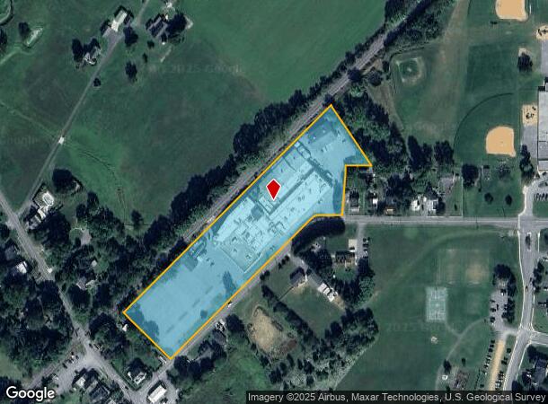
5520 Adamstown Rd
Washington-Arlington-Alexandria, DC-VA-MD-WV
Oxford Estates
01-005936
5.11 ACRES W/S ADAMSTOWN ROAD E/S MT. VILLE ROAD
Scientificpharmaceuticalmedicalresearchfacility
Frederick
X
Maryland
24021C0406E
13
2024
5.11 AC
2025
Frederick County
752302
Washington, DC
122,742 SF
DEMOGRAPHICS near 5520 Adamstown Rd
1 Mile
3 Mile
5 Mile
2024 Total Population
2,634
5,073
23,660
2029 Population
2,967
5,703
26,835
Pop Growth 2024-2029
+ 12.64%
+ 12.42%
+ 13.42%
Average Age
40
43
39
2024 Total Households
850
1,820
8,420
HH Growth 2024-2029
+ 13.18%
+ 12.86%
+ 13.88%
Median Household Inc
$151,316
$129,930
$116,632
Avg Household Size
3.00
2.70
2.70
2024 Avg HH Vehicles
3.00
3.00
2.00
Median Home Value
$577,922
$496,295
$420,676
Median Year Built
2001
1994
1997
Nearby Places
Map Layers
Map Styles
 Street
 Aerial
- Restaurants
- Banks
- Shops
- Fitness
- Groceries
PUBLIC TRANSPORTATION
COMMUTER RAIL
Point Of Rocks (BRUNSWICK - WASHINGTON - Maryland Area Regional Commuter Trains (The MARC), Brunswick Line - Maryland Area Regional Commuter Trains (The MARC))
DRIVE
WALK
Distance
Point Of Rocks (BRUNSWICK - WASHINGTON - Maryland Area Regional Commuter Trains (The MARC), Brunswick Line - Maryland Area Regional Commuter Trains (The MARC))
14 min
7.3 mi
Monocacy Marc Eb (BRUNSWICK - WASHINGTON - Maryland Transit Administration)
DRIVE
WALK
Distance
Monocacy Marc Eb (BRUNSWICK - WASHINGTON - Maryland Transit Administration)
17 min
8.4 mi
AIRPORT
Washington Dulles International
DRIVE
WALK
Distance
Washington Dulles International
60 min
35.7 mi
Freight Ports
Port of Baltimore
DRIVE
WALK
Distance
Port of Baltimore
75 min
57.5 mi
Nearby Properties
Address
Land Use
TOTAL SIZE
Lot Size
Zoning
Address
Land Use
TOTAL SIZE
Lot Size
Zoning
3,478 SF
571.39 AC
GI
Address
Land Use
TOTAL SIZE
Lot Size
Zoning
151.16 AC
GI
Address
Land Use
TOTAL SIZE
Lot Size
Zoning
243,719 SF
37.59 AC
IE
Address
Land Use
TOTAL SIZE
Lot Size
Zoning
108.96 AC
I
Address
Land Use
TOTAL SIZE
Lot Size
Zoning
38,428 SF
74.89 AC
GI
Address
Land Use
TOTAL SIZE
Lot Size
Zoning
2,925 SF
423.90 AC
GI
Address
Land Use
TOTAL SIZE
Lot Size
Zoning
89,904 SF
18.90 AC
IE
Address
Land Use
TOTAL SIZE
Lot Size
Zoning
35.64 AC
GI
Address
Land Use
TOTAL SIZE
Lot Size
Zoning
3,478 SF
235.16 AC
GI
Address
Land Use
TOTAL SIZE
Lot Size
Zoning
68,880 SF
6.50 AC
LI
Address
Land Use
TOTAL SIZE
Lot Size
Zoning
53,764 SF
153.40 AC
A
Address
Land Use
TOTAL SIZE
Lot Size
Zoning
60,525 SF
25.16 AC
GI
Address
Land Use
TOTAL SIZE
Lot Size
Zoning
36,518 SF
38.47 AC
A
Address
Land Use
TOTAL SIZE
Lot Size
Zoning
67,344 SF
10 AC
LI
Address
Land Use
TOTAL SIZE
Lot Size
Zoning
24,563 SF
21.87 AC
A
Address
Land Use
TOTAL SIZE
Lot Size
Zoning
37,720 SF
5.80 AC
LI
Address
Land Use
TOTAL SIZE
Lot Size
Zoning
64.38 AC
GI
Address
Land Use
TOTAL SIZE
Lot Size
Zoning
26,922 SF
103.43 AC
A
Address
Land Use
TOTAL SIZE
Lot Size
Zoning
39,928 SF
6.67 AC
LI
Address
Land Use
TOTAL SIZE
Lot Size
Zoning
39,600 SF
6.46 AC
LI
Address
Land Use
TOTAL SIZE
Lot Size
Zoning
52,400 SF
6.57 AC
LI
Address
Land Use
TOTAL SIZE
Lot Size
Zoning
50,795 SF
20.27 AC
LI
Address
Land Use
TOTAL SIZE
Lot Size
Zoning
35,750 SF
8.61 AC
LI
Address
Land Use
TOTAL SIZE
Lot Size
Zoning
24,900 SF
6.34 AC
A
Address
Land Use
TOTAL SIZE
Lot Size
Zoning
20,000 SF
3.35 AC
LI
Address
Land Use
TOTAL SIZE
Lot Size
Zoning
29,654 SF
6.34 AC
LI
Address
Land Use
TOTAL SIZE
Lot Size
Zoning
33,000 SF
3.53 AC
LI
Address
Land Use
TOTAL SIZE
Lot Size
Zoning
31,358 SF
9.90 AC
LI
Address
Land Use
TOTAL SIZE
Lot Size
Zoning
10,838 SF
5.68 AC
LI
The World's #1 Commercial Real Estate Marketplace
Connect with us
© 2025 CoStar Group
The information above has been obtained from sources believed reliable. While we do not doubt its accuracy we have not verified it and make no guarantee, warranty or representation about it. It is your responsibility to independently confirm its accuracy and completeness. Any projections, opinions, assumptions, or estimates used are for example only and do not represent the current or future performance of the property. The value of this transaction to you depends on tax and other factors which should be evaluated by your tax, financial, and legal advisors. You and your advisors should conduct a careful, independent investigation of the property to determine to your satisfaction the suitability of the property for your needs.