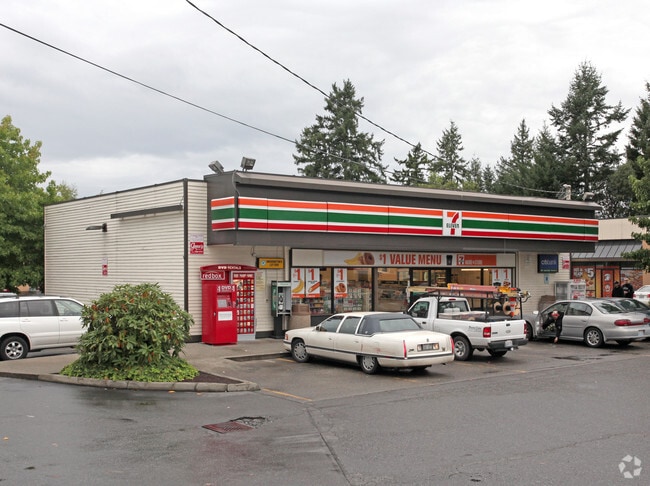
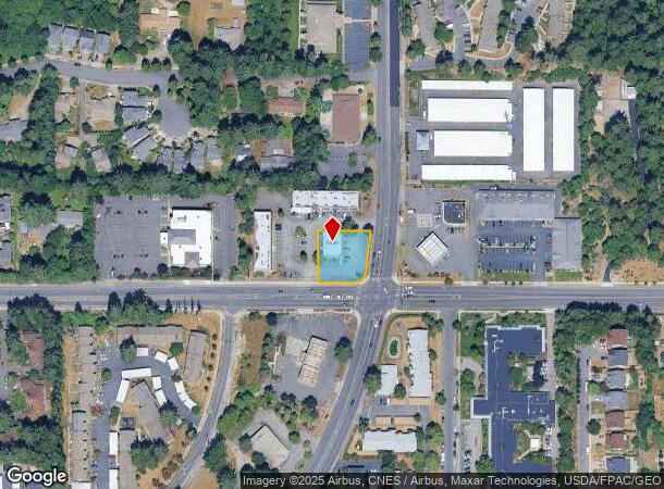
Property Record
5520 Orchard St W, University Place, WA 98467


NEARBY LISTINGS FOR SALE OR LEASE
Property Detail
5520 Orchard St W
022023-1102
SECTION 23 TOWNSHIP 20 RANGE 02 QUARTER 14 : COM AT SE COR OF NE TH N 00 DEG 12 MIN 33 SEC W ALG E LI 165 FT TH S 89 DEG 20 MIN 12 SEC W 32.57 FT TO A PT ON W R/W LI OF ORCHARD ST AS DEED IN HANNA- PIERCE CO RD REEVISION FILED UND AFN 1478253 & POB T
Servicestationmarket
Pierce
X
Washington
53053C0284E
i
2024
0.36 AC
2025
Univ. Place/Lakewood
072313
Seattle/Puget Sound
2,400 SF
Seattle-Tacoma-Bellevue, WA
DEMOGRAPHICS near 5520 Orchard St W
1 Mile
3 Mile
5 Mile
2024 Total Population
13,875
124,546
321,288
2029 Population
14,260
128,475
332,171
Pop Growth 2024-2029
+ 2.77%
+ 3.15%
+ 3.39%
Average Age
38
39
39
2024 Total Households
5,248
50,166
128,197
HH Growth 2024-2029
+ 2.90%
+ 3.25%
+ 3.55%
Median Household Inc
$76,304
$70,963
$72,080
Avg Household Size
2.50
2.40
2.40
2024 Avg HH Vehicles
2.00
2.00
2.00
Median Home Value
$448,025
$427,782
$434,966
Median Year Built
1984
1975
1972
Nearby Places
Map Layers
Map Styles
 Street
 Aerial
- Restaurants
- Banks
- Shops
- Fitness
- Groceries
PUBLIC TRANSPORTATION
COMMUTER RAIL
DRIVE
WALK
Distance
3 min
1.2 mi
DRIVE
WALK
Distance
9 min
5.1 mi
AIRPORT
Seattle-Tacoma International
DRIVE
WALK
Distance
Seattle-Tacoma International
41 min
26.2 mi
Freight Ports
Port of Tacoma
DRIVE
WALK
Distance
Port of Tacoma
13 min
7.4 mi
Nearby Properties
Address
Land Use
TOTAL SIZE
Lot Size
Zoning
Address
Land Use
TOTAL SIZE
Lot Size
Zoning
618,098 SF
150.67 AC
CCX
Address
Land Use
TOTAL SIZE
Lot Size
Zoning
515,971 SF
42.45 AC
Address
Land Use
TOTAL SIZE
Lot Size
Zoning
566,355 SF
69.03 AC
Address
Land Use
TOTAL SIZE
Lot Size
Zoning
1,056,518 SF
65.31 AC
LKWD
Address
Land Use
TOTAL SIZE
Lot Size
Zoning
412,549 SF
56.87 AC
R1
Address
Land Use
TOTAL SIZE
Lot Size
Zoning
309,156 SF
33.79 AC
M2
Address
Land Use
TOTAL SIZE
Lot Size
Zoning
296,154 SF
46.83 AC
R2
Address
Land Use
TOTAL SIZE
Lot Size
Zoning
358,200 SF
27.25 AC
R3
Address
Land Use
TOTAL SIZE
Lot Size
Zoning
238,852 SF
15.34 AC
OSR1
Address
Land Use
TOTAL SIZE
Lot Size
Zoning
100,856 SF
19.76 AC
R2
Address
Land Use
TOTAL SIZE
Lot Size
Zoning
244,143 SF
11.79 AC
MF3
Address
Land Use
TOTAL SIZE
Lot Size
Zoning
211,786 SF
16.84 AC
MF2
Address
Land Use
TOTAL SIZE
Lot Size
Zoning
149,844 SF
11.50 AC
MF
Address
Land Use
TOTAL SIZE
Lot Size
Zoning
223,447 SF
40.44 AC
RCX
Address
Land Use
TOTAL SIZE
Lot Size
Zoning
254,934 SF
5.02 AC
MF
Address
Land Use
TOTAL SIZE
Lot Size
Zoning
140,287 SF
12.95 AC
MF2
Address
Land Use
TOTAL SIZE
Lot Size
Zoning
162,000 SF
9.93 AC
Address
Land Use
TOTAL SIZE
Lot Size
Zoning
125,725 SF
9.17 AC
MF2
Address
Land Use
TOTAL SIZE
Lot Size
Zoning
67,612 SF
2.93 AC
TAC
Address
Land Use
TOTAL SIZE
Lot Size
Zoning
149,364 SF
35.69 AC
PI
Address
Land Use
TOTAL SIZE
Lot Size
Zoning
332,140 SF
9.23 AC
M2
Address
Land Use
TOTAL SIZE
Lot Size
Zoning
128,914 SF
16.03 AC
Address
Land Use
TOTAL SIZE
Lot Size
Zoning
61.20 AC
M2
Address
Land Use
TOTAL SIZE
Lot Size
Zoning
119,926 SF
10.87 AC
HM
Address
Land Use
TOTAL SIZE
Lot Size
Zoning
109,674 SF
2.49 AC
R4L
Address
Land Use
TOTAL SIZE
Lot Size
Zoning
160,514 SF
15.61 AC
MF2
Address
Land Use
TOTAL SIZE
Lot Size
Zoning
293,624 SF
21.16 AC
IBP
Address
Land Use
TOTAL SIZE
Lot Size
Zoning
169,397 SF
18.65 AC
CBD
Address
Land Use
TOTAL SIZE
Lot Size
Zoning
28,966 SF
101.94 AC
R2
Address
Land Use
TOTAL SIZE
Lot Size
Zoning
133,660 SF
6.79 AC
MF
The World's #1 Commercial Real Estate Marketplace
Connect with us
© 2025 CoStar Group
The information above has been obtained from sources believed reliable. While we do not doubt its accuracy we have not verified it and make no guarantee, warranty or representation about it. It is your responsibility to independently confirm its accuracy and completeness. Any projections, opinions, assumptions, or estimates used are for example only and do not represent the current or future performance of the property. The value of this transaction to you depends on tax and other factors which should be evaluated by your tax, financial, and legal advisors. You and your advisors should conduct a careful, independent investigation of the property to determine to your satisfaction the suitability of the property for your needs.