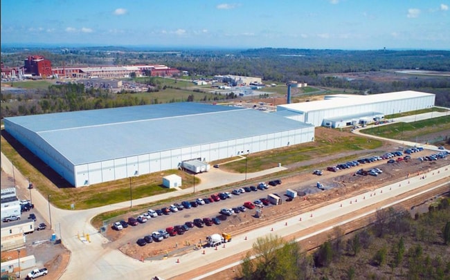
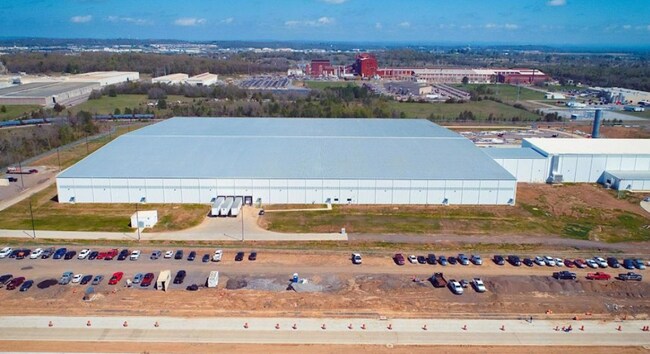
Property Record
5520 Planters Rd, Fort Smith, AR 72916
NEARBY LISTINGS FOR SALE OR LEASE
Property Detail
5520 Planters Rd
Fort Smith, AR-OK
Little Massard Creek
14010-0001-00000-00
LOT 1
Lightindustrial
Sebastian
X
Arkansas
05131C0120F
1
2025
33.51 AC
2025
Greater Ft Smith
001306
Fort Smith
168,195 SF
DEMOGRAPHICS near 5520 Planters Rd
1 Mile
3 Mile
5 Mile
2024 Total Population
129
20,144
58,813
2029 Population
128
20,470
59,904
Pop Growth 2024-2029
(0.78%)
+ 1.62%
+ 1.86%
Average Age
42
40
41
2024 Total Households
52
8,603
25,062
HH Growth 2024-2029
(1.92%)
+ 1.78%
+ 1.88%
Median Household Inc
$85,000
$61,231
$56,034
Avg Household Size
2.50
2.30
2.30
2024 Avg HH Vehicles
2.00
2.00
2.00
Median Home Value
$148,529
$191,846
$178,898
Median Year Built
1991
1992
1983
Nearby Places
Map Layers
Map Styles
 Street
 Aerial
- Restaurants
- Banks
- Shops
- Fitness
- Groceries
PUBLIC TRANSPORTATION
AIRPORT
Fort Smith Regional
DRIVE
WALK
Distance
Fort Smith Regional
16 min
6.0 mi
Freight Ports
Tulsa Port of Inola
DRIVE
WALK
Distance
Tulsa Port of Inola
145 min
112.4 mi
SALE & LEASE HISTORY
LISTING DATE
SALE/LEASE

Jun 19, 2024
For Sale
Nearby Properties
Address
Land Use
TOTAL SIZE
Lot Size
Zoning
Address
Land Use
TOTAL SIZE
Lot Size
Zoning
68,309 SF
40.45 AC
Address
Land Use
TOTAL SIZE
Lot Size
Zoning
124,455 SF
38.09 AC
Address
Land Use
TOTAL SIZE
Lot Size
Zoning
276,870 SF
36.85 AC
Address
Land Use
TOTAL SIZE
Lot Size
Zoning
364,749 SF
32.41 AC
Address
Land Use
TOTAL SIZE
Lot Size
Zoning
212,590 SF
30.06 AC
Address
Land Use
TOTAL SIZE
Lot Size
Zoning
208,886 SF
212.42 AC
Address
Land Use
TOTAL SIZE
Lot Size
Zoning
342,092 SF
12.15 AC
Address
Land Use
TOTAL SIZE
Lot Size
Zoning
847,154 SF
66.34 AC
Address
Land Use
TOTAL SIZE
Lot Size
Zoning
21,556 SF
47 AC
Address
Land Use
TOTAL SIZE
Lot Size
Zoning
205,000 SF
30 AC
Address
Land Use
TOTAL SIZE
Lot Size
Zoning
1,174,056 SF
90.54 AC
Address
Land Use
TOTAL SIZE
Lot Size
Zoning
47,905 SF
27 AC
Address
Land Use
TOTAL SIZE
Lot Size
Zoning
329,889 SF
31.78 AC
Address
Land Use
TOTAL SIZE
Lot Size
Zoning
3,675 SF
21.98 AC
Address
Land Use
TOTAL SIZE
Lot Size
Zoning
13,911 SF
25.40 AC
Address
Land Use
TOTAL SIZE
Lot Size
Zoning
356,451 SF
44.13 AC
Address
Land Use
TOTAL SIZE
Lot Size
Zoning
242,000 SF
10.62 AC
Address
Land Use
TOTAL SIZE
Lot Size
Zoning
181,710 SF
14.14 AC
Address
Land Use
TOTAL SIZE
Lot Size
Zoning
340,729 SF
26.25 AC
Address
Land Use
TOTAL SIZE
Lot Size
Zoning
89,157 SF
15.84 AC
Address
Land Use
TOTAL SIZE
Lot Size
Zoning
613,600 SF
54.46 AC
Address
Land Use
TOTAL SIZE
Lot Size
Zoning
419,250 SF
22.86 AC
Address
Land Use
TOTAL SIZE
Lot Size
Zoning
125,968 SF
9.46 AC
Address
Land Use
TOTAL SIZE
Lot Size
Zoning
418,608 SF
27.04 AC
Address
Land Use
TOTAL SIZE
Lot Size
Zoning
108,519 SF
13.38 AC
Address
Land Use
TOTAL SIZE
Lot Size
Zoning
54,697 SF
7.87 AC
Address
Land Use
TOTAL SIZE
Lot Size
Zoning
229,814 SF
90 AC
Address
Land Use
TOTAL SIZE
Lot Size
Zoning
18,492 SF
2.03 AC
Address
Land Use
TOTAL SIZE
Lot Size
Zoning
29,522 SF
25 AC
Address
Land Use
TOTAL SIZE
Lot Size
Zoning
105.25 AC
The World's #1 Commercial Real Estate Marketplace
Connect with us
© 2025 CoStar Group
The information above has been obtained from sources believed reliable. While we do not doubt its accuracy we have not verified it and make no guarantee, warranty or representation about it. It is your responsibility to independently confirm its accuracy and completeness. Any projections, opinions, assumptions, or estimates used are for example only and do not represent the current or future performance of the property. The value of this transaction to you depends on tax and other factors which should be evaluated by your tax, financial, and legal advisors. You and your advisors should conduct a careful, independent investigation of the property to determine to your satisfaction the suitability of the property for your needs.