Property Record
5520 Summit Pointe Cir, Bradenton, FL 34210
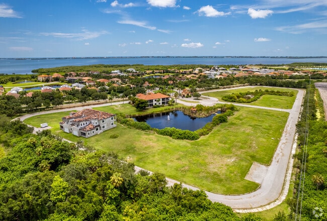
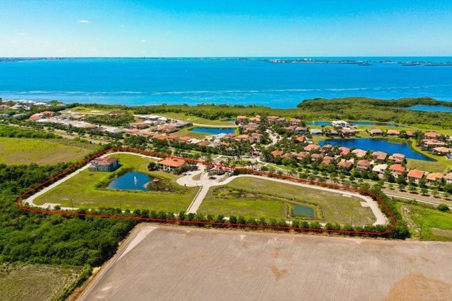
Property Detail
5520 Summit Pointe Cir
North Port-Bradenton-Sarasota, FL
PH 2: COM AT THE NE COR OF SEC 20, TWN 35, RNG 17; TH N 89 DEG 23 MIN 40 SEC W, ALG THE N LN OF SD SEC 20, A DIST OF 929.23 FT; TH S 24 DEG 04 MIN 54 SEC W, A DIST OF 481.70 FT
61471-0080-9
MANATEE
Vacantlandnec
Florida
PD-MU
4
AE The base floodplain where base flood elevations are provided. AE Zones are now used on new format FIRMs instead of A1-A30 Zones.
0.33 AC
2024
Manatee
2025
Tampa/St Petersburg
001104
NEARBY LISTINGS FOR SALE OR LEASE
DEMOGRAPHICS near 5520 Summit Pointe Cir
1 mile
3 mile
5 mile
2025 Total Population
3,388
59,032
157,690
2030 Population
4,080
66,380
176,269
Pop Growth 2025-2030
+ 20.43%
+ 12.45%
+ 11.78%
Average Age
53
47
47
2025 Total Households
1,838
28,152
70,684
HH Growth 2025-2030
+ 20.62%
+ 12.84%
+ 12.29%
Median Household Inc
$93,341
$62,870
$60,751
Avg Household Size
1.80
2.00
2.10
2025 Avg HH Vehicles
1.00
1.00
2.00
Median Home Value
$575,087
$265,943
$292,495
Median Year Built
1996
1981
1978
Nearby Places
Map Layers
Map Styles
 Street
 Aerial
Transit
 Traffic
 Biking
Places
Listings with unknown addresses are not visible on the map
- Restaurants
- Banks
- Shops
- Fitness
- Groceries
PUBLIC TRANSPORTATION
AIRPORT
Sarasota/Bradenton International
Drive
Walk
Distance
Sarasota/Bradenton International
13 min
5.5 mi
Freight Ports
Port Manatee
Drive
Walk
Distance
Port Manatee
35 min
19.1 mi
SALE & LEASE HISTORY
LISTING DATE
SALE/LEASE

May 28, 2019
For Sale
Jun 21, 2022
For Sale
Nearby Properties
Address
Land Use
TOTAL SIZE
Lot Size
Zoning
Address
Land Use
TOTAL SIZE
Lot Size
Zoning
623,436 SF
88.25 AC
PD-R,MP-I
Address
Land Use
TOTAL SIZE
Lot Size
Zoning
422,640 SF
12.10 AC
PD-R
Address
Land Use
TOTAL SIZE
Lot Size
Zoning
437,460 SF
46.14 AC
PD-R
Address
Land Use
TOTAL SIZE
Lot Size
Zoning
356,808 SF
24.25 AC
RMF-9 MULT
Address
Land Use
TOTAL SIZE
Lot Size
Zoning
456,263 SF
28.02 AC
BR_R-3
Address
Land Use
TOTAL SIZE
Lot Size
Zoning
314,018 SF
28.20 AC
BR_R-3
Address
Land Use
TOTAL SIZE
Lot Size
Zoning
645,805 SF
91.21 AC
PD-PI
Address
Land Use
TOTAL SIZE
Lot Size
Zoning
279,545 SF
19.41 AC
BR_R-1
Address
Land Use
TOTAL SIZE
Lot Size
Zoning
395,543 SF
29.18 AC
BR_R-3
Address
Land Use
TOTAL SIZE
Lot Size
Zoning
507,194 SF
8.49 AC
Address
Land Use
TOTAL SIZE
Lot Size
Zoning
247,280 SF
17.72 AC
PD-R
Address
Land Use
TOTAL SIZE
Lot Size
Zoning
294,609 SF
19.15 AC
RMF9
Address
Land Use
TOTAL SIZE
Lot Size
Zoning
235,443 SF
14.75 AC
RMF-9 MULT
Address
Land Use
TOTAL SIZE
Lot Size
Zoning
117,547 SF
11.64 AC
MP-I
Address
Land Use
TOTAL SIZE
Lot Size
Zoning
153,663 SF
110.35 AC
MP-I
Address
Land Use
TOTAL SIZE
Lot Size
Zoning
214,906 SF
20.71 AC
BR_R-1
Address
Land Use
TOTAL SIZE
Lot Size
Zoning
500,923 SF
47.91 AC
Address
Land Use
TOTAL SIZE
Lot Size
Zoning
223,974 SF
17.41 AC
BR_R-2
Address
Land Use
TOTAL SIZE
Lot Size
Zoning
335,019 SF
32.58 AC
BR_R-3
Address
Land Use
TOTAL SIZE
Lot Size
Zoning
247,592 SF
13.39 AC
GC,RMF-6
Address
Land Use
TOTAL SIZE
Lot Size
Zoning
162,027 SF
14.21 AC
BR_R-2
Address
Land Use
TOTAL SIZE
Lot Size
Zoning
331,144 SF
40.48 AC
PD-PI
Address
Land Use
TOTAL SIZE
Lot Size
Zoning
159,960 SF
11.30 AC
RMF-9 MULT
Address
Land Use
TOTAL SIZE
Lot Size
Zoning
179,650 SF
10.63 AC
RMF-9 MULT
Address
Land Use
TOTAL SIZE
Lot Size
Zoning
179,042 SF
6.60 AC
PD-MU
Address
Land Use
TOTAL SIZE
Lot Size
Zoning
106,355 SF
120.66 AC
BR_PDP
Address
Land Use
TOTAL SIZE
Lot Size
Zoning
118,425 SF
320.26 AC
Address
Land Use
TOTAL SIZE
Lot Size
Zoning
112,857 SF
10.12 AC
GC GENERA
Address
Land Use
TOTAL SIZE
Lot Size
Zoning
153,564 SF
9.69 AC
MP-I
Address
Land Use
TOTAL SIZE
Lot Size
Zoning
171,396 SF
15.03 AC
GC GENERA
The World's #1 Commercial Real Estate Marketplace
Connect with us
© 2026 CoStar Group
The information above has been obtained from sources believed reliable. While we do not doubt its accuracy we have not verified it and make no guarantee, warranty or representation about it. It is your responsibility to independently confirm its accuracy and completeness. Any projections, opinions, assumptions, or estimates used are for example only and do not represent the current or future performance of the property. The value of this transaction to you depends on tax and other factors which should be evaluated by your tax, financial, and legal advisors. You and your advisors should conduct a careful, independent investigation of the property to determine to your satisfaction the suitability of the property for your needs.