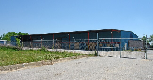
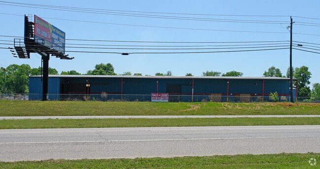
Property Record
5521 Mcfarland Blvd, Northport, AL 35476
NEARBY LISTINGS FOR SALE OR LEASE
Property Detail
5521 Mcfarland Blvd
31-03-08-3-004-004.001
COM SW COR S8 T21S R10W; E 928(S); N 1268(S) TO POB; N 420; NE 345.9; S 530.4; W 332.8 TO POB
Storebuilding
Tuscaloosa
X
Alabama
01125C0501G
3.77 AC
2025
Tuscaloosa
2024
Birmingham
010302
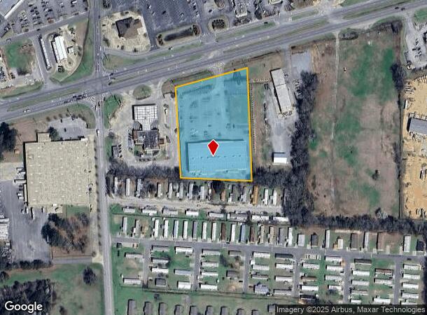
Tuscaloosa, AL
34,272 SF
DEMOGRAPHICS near 5521 Mcfarland Blvd
1 Mile
3 Mile
5 Mile
2024 Total Population
2,743
27,480
91,683
2029 Population
3,091
31,051
102,459
Pop Growth 2024-2029
+ 12.69%
+ 12.99%
+ 11.75%
Average Age
38
40
34
2024 Total Households
1,052
11,023
32,499
HH Growth 2024-2029
+ 12.26%
+ 12.84%
+ 14.30%
Median Household Inc
$62,191
$60,849
$44,259
Avg Household Size
2.50
2.20
2.20
2024 Avg HH Vehicles
2.00
2.00
2.00
Median Home Value
$170,437
$195,355
$213,923
Median Year Built
1990
1984
1988
Nearby Places
Map Layers
Map Styles
 Street
 Aerial
- Restaurants
- Banks
- Shops
- Fitness
- Groceries
PUBLIC TRANSPORTATION
COMMUTER RAIL
Tuscaloosa Amtrak Station (Crescent - Amtrak)
DRIVE
WALK
Distance
Tuscaloosa Amtrak Station (Crescent - Amtrak)
9 min
5.0 mi
Freight Ports
Port of Mobile
DRIVE
WALK
Distance
Port of Mobile
244 min
201.8 mi
Nearby Properties
Address
Land Use
TOTAL SIZE
Lot Size
Zoning
Address
Land Use
TOTAL SIZE
Lot Size
Zoning
148,656 SF
2.79 AC
BC
Address
Land Use
TOTAL SIZE
Lot Size
Zoning
24,360 SF
142 AC
Address
Land Use
TOTAL SIZE
Lot Size
Zoning
121,384 SF
21 AC
O-I
Address
Land Use
TOTAL SIZE
Lot Size
Zoning
174,000 SF
28.67 AC
R1
Address
Land Use
TOTAL SIZE
Lot Size
Zoning
173,452 SF
2.30 AC
ML
Address
Land Use
TOTAL SIZE
Lot Size
Zoning
110,000 SF
5.80 AC
RD
Address
Land Use
TOTAL SIZE
Lot Size
Zoning
26,576 SF
2.53 AC
RD
Address
Land Use
TOTAL SIZE
Lot Size
Zoning
15.30 AC
Address
Land Use
TOTAL SIZE
Lot Size
Zoning
12,048 SF
21 AC
RM2
Address
Land Use
TOTAL SIZE
Lot Size
Zoning
361,935 SF
133.67 AC
MH
Address
Land Use
TOTAL SIZE
Lot Size
Zoning
301,560 SF
15 AC
ML
Address
Land Use
TOTAL SIZE
Lot Size
Zoning
10,852 SF
46 AC
I
Address
Land Use
TOTAL SIZE
Lot Size
Zoning
73,848 SF
1.73 AC
BGO
Address
Land Use
TOTAL SIZE
Lot Size
Zoning
96,885 SF
2.34 AC
RD
Address
Land Use
TOTAL SIZE
Lot Size
Zoning
10,440 SF
12 AC
Address
Land Use
TOTAL SIZE
Lot Size
Zoning
32,640 SF
9.80 AC
C6
Address
Land Use
TOTAL SIZE
Lot Size
Zoning
143,038 SF
36 AC
O-I
Address
Land Use
TOTAL SIZE
Lot Size
Zoning
7,752 SF
11 AC
R4
Address
Land Use
TOTAL SIZE
Lot Size
Zoning
50,652 SF
19.03 AC
ML
Address
Land Use
TOTAL SIZE
Lot Size
Zoning
73,904 SF
0.97 AC
BC
Address
Land Use
TOTAL SIZE
Lot Size
Zoning
3,808 SF
10 AC
R4
Address
Land Use
TOTAL SIZE
Lot Size
Zoning
15,060 SF
11 AC
RM2
Address
Land Use
TOTAL SIZE
Lot Size
Zoning
91,231 SF
7.71 AC
ML
Address
Land Use
TOTAL SIZE
Lot Size
Zoning
59,039 SF
1.35 AC
RD
Address
Land Use
TOTAL SIZE
Lot Size
Zoning
208,996 SF
25 AC
C-6
Address
Land Use
TOTAL SIZE
Lot Size
Zoning
24,684 SF
12 AC
RM2
Address
Land Use
TOTAL SIZE
Lot Size
Zoning
140,412 SF
14.35 AC
C6
Address
Land Use
TOTAL SIZE
Lot Size
Zoning
213,549 SF
8.80 AC
ML
Address
Land Use
TOTAL SIZE
Lot Size
Zoning
211,838 SF
11.71 AC
ML
Address
Land Use
TOTAL SIZE
Lot Size
Zoning
176,846 SF
21.27 AC
ML
The World's #1 Commercial Real Estate Marketplace
Connect with us
© 2026 CoStar Group
The information above has been obtained from sources believed reliable. While we do not doubt its accuracy we have not verified it and make no guarantee, warranty or representation about it. It is your responsibility to independently confirm its accuracy and completeness. Any projections, opinions, assumptions, or estimates used are for example only and do not represent the current or future performance of the property. The value of this transaction to you depends on tax and other factors which should be evaluated by your tax, financial, and legal advisors. You and your advisors should conduct a careful, independent investigation of the property to determine to your satisfaction the suitability of the property for your needs.