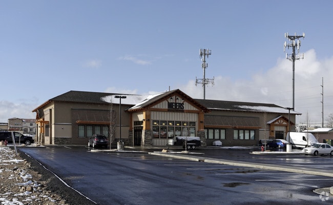
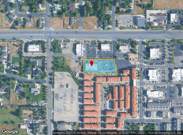
Property Record
5521 W 11000 Hwy N, Highland, UT 84003

NEARBY LISTINGS FOR SALE OR LEASE
-
-
View all Highland listings for sale on LoopNet.com
Property Detail
5521 W 11000 Hwy N
Salt Lake City
Highland Town Center
Provo-Orem, UT
PART LOT 1, HIGHLAND TOWN CENTER, PLAT 2 SUB DESCRIBED AS FOLLOWS:; COM N 1286.96 FT & E 358.53 FT & S 0 DEG 4 53 E 187.51 FT FR W 1/4 COR. SEC. 36, T4S, R1E, SLB&M.; E 306.74 FT; S 25.07 FT; ALONG A CURVE TO L (CHORD BEARS: S 23 DEG 41 13 E 44.99 FT
41-731-0003
Utah
Storebuilding
Utah
2024
1
2025
1.03 AC
010219
Utah County
13,373 SF
DEMOGRAPHICS near 5521 W 11000 Hwy N
1 Mile
3 Mile
5 Mile
2024 Total Population
6,910
60,783
149,870
2029 Population
8,009
70,836
175,008
Pop Growth 2024-2029
+ 15.90%
+ 16.54%
+ 16.77%
Average Age
35
34
33
2024 Total Households
1,769
15,224
41,290
HH Growth 2024-2029
+ 16.34%
+ 16.96%
+ 17.13%
Median Household Inc
$162,822
$141,375
$114,196
Avg Household Size
3.90
4.00
3.60
2024 Avg HH Vehicles
3.00
3.00
3.00
Median Home Value
$729,268
$684,173
$576,899
Median Year Built
2003
2002
2003
Nearby Places
Map Layers
Map Styles
 Street
 Aerial
- Restaurants
- Banks
- Shops
- Fitness
- Groceries
PUBLIC TRANSPORTATION
COMMUTER RAIL
American Fork Station (FrontRunner - Utah Transit Authority (UTA))
DRIVE
WALK
Distance
American Fork Station (FrontRunner - Utah Transit Authority (UTA))
12 min
6.0 mi
Lehi Station (FrontRunner - Utah Transit Authority (UTA))
DRIVE
WALK
Distance
Lehi Station (FrontRunner - Utah Transit Authority (UTA))
11 min
6.3 mi
AIRPORT
Provo Municipal
DRIVE
WALK
Distance
Provo Municipal
29 min
19.7 mi
Salt Lake City International
DRIVE
WALK
Distance
Salt Lake City International
42 min
34.3 mi
Freight Ports
Port of Stockton
DRIVE
WALK
Distance
Port of Stockton
742 min
724.7 mi
Nearby Properties
Address
Land Use
TOTAL SIZE
Lot Size
Zoning
Address
Land Use
TOTAL SIZE
Lot Size
Zoning
2,586,860 SF
99.85 AC
Address
Land Use
TOTAL SIZE
Lot Size
Zoning
545,572 SF
182.84 AC
Address
Land Use
TOTAL SIZE
Lot Size
Zoning
165,821 SF
12.29 AC
Address
Land Use
TOTAL SIZE
Lot Size
Zoning
242,954 SF
13.54 AC
Address
Land Use
TOTAL SIZE
Lot Size
Zoning
134,728 SF
13.07 AC
Address
Land Use
TOTAL SIZE
Lot Size
Zoning
70,678 SF
4.03 AC
Address
Land Use
TOTAL SIZE
Lot Size
Zoning
43,345 SF
4.06 AC
Address
Land Use
TOTAL SIZE
Lot Size
Zoning
81,136 SF
1.85 AC
Address
Land Use
TOTAL SIZE
Lot Size
Zoning
32,740 SF
153.49 AC
Address
Land Use
TOTAL SIZE
Lot Size
Zoning
90,581 SF
3.87 AC
Address
Land Use
TOTAL SIZE
Lot Size
Zoning
33,163 SF
1.64 AC
Address
Land Use
TOTAL SIZE
Lot Size
Zoning
52,429 SF
2.05 AC
Address
Land Use
TOTAL SIZE
Lot Size
Zoning
47,873 SF
2.24 AC
Address
Land Use
TOTAL SIZE
Lot Size
Zoning
15,094 SF
1.73 AC
Address
Land Use
TOTAL SIZE
Lot Size
Zoning
18,918 SF
1.75 AC
Address
Land Use
TOTAL SIZE
Lot Size
Zoning
28,331 SF
5 AC
Address
Land Use
TOTAL SIZE
Lot Size
Zoning
5,954 SF
1.29 AC
Address
Land Use
TOTAL SIZE
Lot Size
Zoning
10,251 SF
1.06 AC
Address
Land Use
TOTAL SIZE
Lot Size
Zoning
4,048 SF
1.75 AC
Address
Land Use
TOTAL SIZE
Lot Size
Zoning
14,453 SF
1.13 AC
Address
Land Use
TOTAL SIZE
Lot Size
Zoning
15,924 SF
0.98 AC
Address
Land Use
TOTAL SIZE
Lot Size
Zoning
15,206 SF
1.14 AC
Address
Land Use
TOTAL SIZE
Lot Size
Zoning
1,953 SF
13.40 AC
Address
Land Use
TOTAL SIZE
Lot Size
Zoning
23,143 SF
11.67 AC
Address
Land Use
TOTAL SIZE
Lot Size
Zoning
4,341 SF
1.57 AC
Address
Land Use
TOTAL SIZE
Lot Size
Zoning
19,208 SF
0.14 AC
Address
Land Use
TOTAL SIZE
Lot Size
Zoning
15,552 SF
0.72 AC
Address
Land Use
TOTAL SIZE
Lot Size
Zoning
5,269 SF
2.05 AC
Address
Land Use
TOTAL SIZE
Lot Size
Zoning
18,011 SF
0.66 AC
Address
Land Use
TOTAL SIZE
Lot Size
Zoning
31.44 AC
The World's #1 Commercial Real Estate Marketplace
Connect with us
© 2025 CoStar Group
The information above has been obtained from sources believed reliable. While we do not doubt its accuracy we have not verified it and make no guarantee, warranty or representation about it. It is your responsibility to independently confirm its accuracy and completeness. Any projections, opinions, assumptions, or estimates used are for example only and do not represent the current or future performance of the property. The value of this transaction to you depends on tax and other factors which should be evaluated by your tax, financial, and legal advisors. You and your advisors should conduct a careful, independent investigation of the property to determine to your satisfaction the suitability of the property for your needs.