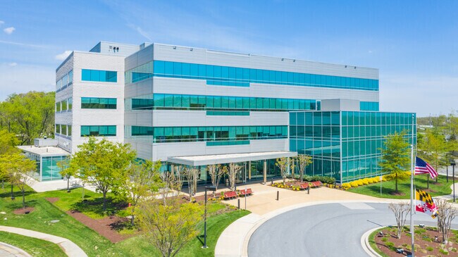
Property Record
5525 Research Park Dr, Catonsville, MD 21228

NEARBY LISTINGS FOR SALE OR LEASE
Property Detail
5525 Research Park Dr
01-2500003763
Umbc Research Park Umbc
Officebuilding
4.012AC UMBC RESEARCH PARK UMBC
X
Baltimore
2400100502G
Maryland
2024
4.01 AC
2025
BWI/Baltimore County
492500
Baltimore
87,140 SF
Baltimore-Columbia-Towson, MD
DEMOGRAPHICS near 5525 Research Park Dr
1 Mile
3 Mile
5 Mile
2024 Total Population
13,466
84,785
270,032
2029 Population
13,240
82,810
267,850
Pop Growth 2024-2029
(1.68%)
(2.33%)
(0.81%)
Average Age
34
40
39
2024 Total Households
3,745
31,777
102,457
HH Growth 2024-2029
(2.06%)
(2.72%)
(1.01%)
Median Household Inc
$101,189
$73,858
$65,007
Avg Household Size
2.50
2.40
2.50
2024 Avg HH Vehicles
2.00
2.00
1.00
Median Home Value
$279,269
$286,749
$277,999
Median Year Built
1957
1957
1958
Nearby Places
Map Layers
Map Styles
 Street
 Aerial
- Restaurants
- Banks
- Shops
- Fitness
- Groceries
PUBLIC TRANSPORTATION
COMMUTER RAIL
DRIVE
WALK
Distance
9 min
4.1 mi
DRIVE
WALK
Distance
9 min
4.1 mi
AIRPORT
Baltimore/Washington International Thurgood Marshall
DRIVE
WALK
Distance
Baltimore/Washington International Thurgood Marshall
11 min
6.1 mi
Ronald Reagan Washington Ntl
DRIVE
WALK
Distance
Ronald Reagan Washington Ntl
58 min
37.5 mi
Freight Ports
Port of Baltimore
DRIVE
WALK
Distance
Port of Baltimore
16 min
9.0 mi
Nearby Properties
Address
Land Use
TOTAL SIZE
Lot Size
Zoning
Address
Land Use
TOTAL SIZE
Lot Size
Zoning
1,396,807 SF
32.73 AC
R-6
Address
Land Use
TOTAL SIZE
Lot Size
Zoning
2,182,087 SF
95.52 AC
DR5.5
Address
Land Use
TOTAL SIZE
Lot Size
Zoning
98,318 SF
175.16 AC
OT
Address
Land Use
TOTAL SIZE
Lot Size
Zoning
523,800 SF
28.02 AC
I-1
Address
Land Use
TOTAL SIZE
Lot Size
Zoning
315,055 SF
9.60 AC
ML
Address
Land Use
TOTAL SIZE
Lot Size
Zoning
88,254 SF
105.20 AC
DR2
Address
Land Use
TOTAL SIZE
Lot Size
Zoning
207,168 SF
63.84 AC
DR3.5
Address
Land Use
TOTAL SIZE
Lot Size
Zoning
132,552 SF
47.72 AC
RED
Address
Land Use
TOTAL SIZE
Lot Size
Zoning
184,317 SF
16.23 AC
MH
Address
Land Use
TOTAL SIZE
Lot Size
Zoning
312,231 SF
11.23 AC
R-5
Address
Land Use
TOTAL SIZE
Lot Size
Zoning
40.17 AC
DR16
Address
Land Use
TOTAL SIZE
Lot Size
Zoning
300,513 SF
32.53 AC
I-1
Address
Land Use
TOTAL SIZE
Lot Size
Zoning
48,300 SF
30.96 AC
ML
Address
Land Use
TOTAL SIZE
Lot Size
Zoning
156,834 SF
10.26 AC
DR5.5
Address
Land Use
TOTAL SIZE
Lot Size
Zoning
23.78 AC
DR5.5
Address
Land Use
TOTAL SIZE
Lot Size
Zoning
197,754 SF
12.63 AC
DR5.5
Address
Land Use
TOTAL SIZE
Lot Size
Zoning
101,220 SF
17.51 AC
DR5.5
Address
Land Use
TOTAL SIZE
Lot Size
Zoning
15.29 AC
BLCCL
Address
Land Use
TOTAL SIZE
Lot Size
Zoning
148,500 SF
5.10 AC
Address
Land Use
TOTAL SIZE
Lot Size
Zoning
21.46 AC
ML
Address
Land Use
TOTAL SIZE
Lot Size
Zoning
15.08 AC
DR105
Address
Land Use
TOTAL SIZE
Lot Size
Zoning
132,000 SF
29.26 AC
ML
Address
Land Use
TOTAL SIZE
Lot Size
Zoning
210,000 SF
11.11 AC
MH
Address
Land Use
TOTAL SIZE
Lot Size
Zoning
656,963 SF
30.41 AC
ML
Address
Land Use
TOTAL SIZE
Lot Size
Zoning
443,645 SF
12.28 AC
Address
Land Use
TOTAL SIZE
Lot Size
Zoning
214,265 SF
21.03 AC
BLAS
Address
Land Use
TOTAL SIZE
Lot Size
Zoning
400,495 SF
28 AC
MH
Address
Land Use
TOTAL SIZE
Lot Size
Zoning
283,178 SF
15.84 AC
MH-IM
Address
Land Use
TOTAL SIZE
Lot Size
Zoning
290,924 SF
15.02 AC
MH-IM
Address
Land Use
TOTAL SIZE
Lot Size
Zoning
293,212 SF
17.31 AC
ML
The World's #1 Commercial Real Estate Marketplace
Connect with us
© 2026 CoStar Group
The information above has been obtained from sources believed reliable. While we do not doubt its accuracy we have not verified it and make no guarantee, warranty or representation about it. It is your responsibility to independently confirm its accuracy and completeness. Any projections, opinions, assumptions, or estimates used are for example only and do not represent the current or future performance of the property. The value of this transaction to you depends on tax and other factors which should be evaluated by your tax, financial, and legal advisors. You and your advisors should conduct a careful, independent investigation of the property to determine to your satisfaction the suitability of the property for your needs.