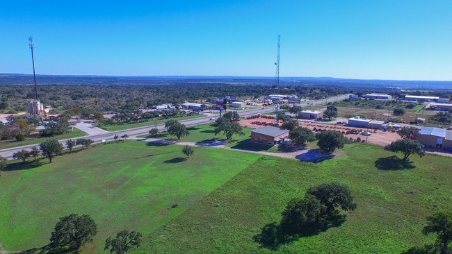
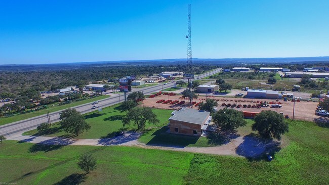
Property Record
5526 N Us Highway 281, Marble Falls, TX 78654


NEARBY LISTINGS FOR SALE OR LEASE
Property Detail
5526 N Us Highway 281
54823
Rafail Padilla
Commercialacreage
ABS A0666 RAFAIL PADILLA,TRACT 5.235 AC AB 666, 2.19 AC S BREWER AB 108,7.425 ACRES
X
Burnet
48053C0470G
Texas
2024
7.43 AC
2025
Central Texas Area
960702
Other Market Areas
DEMOGRAPHICS near 5526 N Us Highway 281
1 Mile
3 Mile
5 Mile
2024 Total Population
34
879
7,961
2029 Population
39
1,012
9,322
Pop Growth 2024-2029
+ 14.71%
+ 15.13%
+ 17.10%
Average Age
43
44
43
2024 Total Households
13
348
3,192
HH Growth 2024-2029
+ 15.38%
+ 14.66%
+ 16.67%
Median Household Inc
$83,333
$78,205
$55,975
Avg Household Size
2.40
2.50
2.40
2024 Avg HH Vehicles
2.00
2.00
2.00
Median Home Value
$299,999
$297,272
$275,156
Median Year Built
1982
1984
1998
Nearby Places
Map Layers
Map Styles
 Street
 Aerial
- Restaurants
- Banks
- Shops
- Fitness
- Groceries
SALE & LEASE HISTORY
LISTING DATE
SALE/LEASE

Sep 23, 2016
For Sale
Oct 07, 2016
For Sale
May 03, 2023
For Sale
Nearby Properties
Address
Land Use
TOTAL SIZE
Lot Size
Zoning
Address
Land Use
TOTAL SIZE
Lot Size
Zoning
54,059 SF
20.69 AC
Address
Land Use
TOTAL SIZE
Lot Size
Zoning
202,505 SF
22.65 AC
Address
Land Use
TOTAL SIZE
Lot Size
Zoning
73,721 SF
9.30 AC
Address
Land Use
TOTAL SIZE
Lot Size
Zoning
110,433 SF
17.07 AC
Address
Land Use
TOTAL SIZE
Lot Size
Zoning
39,159 SF
7 AC
Address
Land Use
TOTAL SIZE
Lot Size
Zoning
58,040 SF
16.71 AC
Address
Land Use
TOTAL SIZE
Lot Size
Zoning
806.90 AC
Address
Land Use
TOTAL SIZE
Lot Size
Zoning
728 SF
138.68 AC
Address
Land Use
TOTAL SIZE
Lot Size
Zoning
17,063 SF
419.34 AC
Address
Land Use
TOTAL SIZE
Lot Size
Zoning
Address
Land Use
TOTAL SIZE
Lot Size
Zoning
30,522 SF
2.50 AC
Address
Land Use
TOTAL SIZE
Lot Size
Zoning
44,050 SF
2.36 AC
Address
Land Use
TOTAL SIZE
Lot Size
Zoning
6,000 SF
5.80 AC
Address
Land Use
TOTAL SIZE
Lot Size
Zoning
16,938 SF
12.09 AC
Address
Land Use
TOTAL SIZE
Lot Size
Zoning
10,900 SF
1.82 AC
Address
Land Use
TOTAL SIZE
Lot Size
Zoning
29,376 SF
10.76 AC
Address
Land Use
TOTAL SIZE
Lot Size
Zoning
212.65 AC
Address
Land Use
TOTAL SIZE
Lot Size
Zoning
30,300 SF
4 AC
Address
Land Use
TOTAL SIZE
Lot Size
Zoning
6,120 SF
10.05 AC
Address
Land Use
TOTAL SIZE
Lot Size
Zoning
21.15 AC
Address
Land Use
TOTAL SIZE
Lot Size
Zoning
18,120 SF
1.68 AC
Address
Land Use
TOTAL SIZE
Lot Size
Zoning
27,553 SF
5 AC
Address
Land Use
TOTAL SIZE
Lot Size
Zoning
60,596 SF
1.65 AC
Address
Land Use
TOTAL SIZE
Lot Size
Zoning
87,271 SF
2 AC
Address
Land Use
TOTAL SIZE
Lot Size
Zoning
17,500 SF
2.24 AC
Address
Land Use
TOTAL SIZE
Lot Size
Zoning
40,106 SF
5.02 AC
Address
Land Use
TOTAL SIZE
Lot Size
Zoning
30,300 SF
1.89 AC
Address
Land Use
TOTAL SIZE
Lot Size
Zoning
9,518 SF
12 AC
Address
Land Use
TOTAL SIZE
Lot Size
Zoning
29,805 SF
3.25 AC
Address
Land Use
TOTAL SIZE
Lot Size
Zoning
5,800 SF
7.19 AC
The World's #1 Commercial Real Estate Marketplace
Connect with us
© 2025 CoStar Group
The information above has been obtained from sources believed reliable. While we do not doubt its accuracy we have not verified it and make no guarantee, warranty or representation about it. It is your responsibility to independently confirm its accuracy and completeness. Any projections, opinions, assumptions, or estimates used are for example only and do not represent the current or future performance of the property. The value of this transaction to you depends on tax and other factors which should be evaluated by your tax, financial, and legal advisors. You and your advisors should conduct a careful, independent investigation of the property to determine to your satisfaction the suitability of the property for your needs.