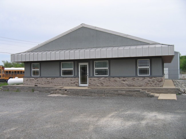
Property Record
5529 Dial Dr, Granite City, IL 62040

NEARBY LISTINGS FOR SALE OR LEASE
Property Detail
5529 Dial Dr
St. Louis
South Fork Sub
St. Louis, MO-IL
Madison
18-1-14-32-00-000-011
Illinois
Mobilemanufacturedhomeregardlessoflandownership
63.01 AC
1,200 SF
Illinois
DEMOGRAPHICS near 5529 Dial Dr
1 Mile
3 Mile
5 Mile
2024 Total Population
1,812
20,878
48,950
2029 Population
1,772
20,645
48,978
Pop Growth 2024-2029
(2.21%)
(1.12%)
+ 0.06%
Average Age
43
43
40
2024 Total Households
745
8,768
19,922
HH Growth 2024-2029
(2.28%)
(1.22%)
(0.08%)
Median Household Inc
$62,443
$61,819
$52,827
Avg Household Size
2.40
2.30
2.40
2024 Avg HH Vehicles
2.00
2.00
2.00
Median Home Value
$111,679
$111,900
$86,212
Median Year Built
1965
1965
1961
Nearby Places
Map Layers
Map Styles
 Street
 Aerial
- Restaurants
- Banks
- Shops
- Fitness
- Groceries
PUBLIC TRANSPORTATION
AIRPORT
St Louis Lambert International
DRIVE
WALK
Distance
St Louis Lambert International
24 min
16.0 mi
Scott AFB/Midamerica St Louis
DRIVE
WALK
Distance
Scott AFB/Midamerica St Louis
52 min
33.1 mi
Freight Ports
Port Milwaukee
DRIVE
WALK
Distance
Port Milwaukee
410 min
362.0 mi
Nearby Properties
Address
Land Use
TOTAL SIZE
Lot Size
Zoning
Address
Land Use
TOTAL SIZE
Lot Size
Zoning
652,425 SF
51.21 AC
Address
Land Use
TOTAL SIZE
Lot Size
Zoning
822,146 SF
46.88 AC
Address
Land Use
TOTAL SIZE
Lot Size
Zoning
540,198 SF
38.96 AC
Address
Land Use
TOTAL SIZE
Lot Size
Zoning
519,819 SF
45.03 AC
Address
Land Use
TOTAL SIZE
Lot Size
Zoning
500,000 SF
25.25 AC
Address
Land Use
TOTAL SIZE
Lot Size
Zoning
422,826 SF
26.15 AC
Address
Land Use
TOTAL SIZE
Lot Size
Zoning
411,272 SF
23.72 AC
Address
Land Use
TOTAL SIZE
Lot Size
Zoning
404,739 SF
39.87 AC
Address
Land Use
TOTAL SIZE
Lot Size
Zoning
440,000 SF
21.36 AC
Address
Land Use
TOTAL SIZE
Lot Size
Zoning
361,826 SF
22.39 AC
Address
Land Use
TOTAL SIZE
Lot Size
Zoning
345,948 SF
32.94 AC
Address
Land Use
TOTAL SIZE
Lot Size
Zoning
272,420 SF
18.40 AC
Address
Land Use
TOTAL SIZE
Lot Size
Zoning
184,803 SF
19.16 AC
Address
Land Use
TOTAL SIZE
Lot Size
Zoning
4,000 SF
29.50 AC
Address
Land Use
TOTAL SIZE
Lot Size
Zoning
55,275 SF
11.75 AC
Address
Land Use
TOTAL SIZE
Lot Size
Zoning
155,258 SF
9.33 AC
Address
Land Use
TOTAL SIZE
Lot Size
Zoning
8,000 SF
16.53 AC
Address
Land Use
TOTAL SIZE
Lot Size
Zoning
132,482 SF
19.31 AC
Address
Land Use
TOTAL SIZE
Lot Size
Zoning
240,069 SF
14.20 AC
Address
Land Use
TOTAL SIZE
Lot Size
Zoning
3,806 SF
10.78 AC
Address
Land Use
TOTAL SIZE
Lot Size
Zoning
14.02 AC
Address
Land Use
TOTAL SIZE
Lot Size
Zoning
17,569 SF
25.03 AC
Address
Land Use
TOTAL SIZE
Lot Size
Zoning
101,185 SF
4.15 AC
Address
Land Use
TOTAL SIZE
Lot Size
Zoning
444 SF
9.80 AC
Address
Land Use
TOTAL SIZE
Lot Size
Zoning
13,300 SF
5.05 AC
Address
Land Use
TOTAL SIZE
Lot Size
Zoning
21.20 AC
Address
Land Use
TOTAL SIZE
Lot Size
Zoning
19,972 SF
13.91 AC
Address
Land Use
TOTAL SIZE
Lot Size
Zoning
46,066 SF
2.94 AC
Address
Land Use
TOTAL SIZE
Lot Size
Zoning
26,154 SF
10.20 AC
Address
Land Use
TOTAL SIZE
Lot Size
Zoning
92,130 SF
11.15 AC
The World's #1 Commercial Real Estate Marketplace
Connect with us
© 2025 CoStar Group
The information above has been obtained from sources believed reliable. While we do not doubt its accuracy we have not verified it and make no guarantee, warranty or representation about it. It is your responsibility to independently confirm its accuracy and completeness. Any projections, opinions, assumptions, or estimates used are for example only and do not represent the current or future performance of the property. The value of this transaction to you depends on tax and other factors which should be evaluated by your tax, financial, and legal advisors. You and your advisors should conduct a careful, independent investigation of the property to determine to your satisfaction the suitability of the property for your needs.