Property Record
553 E Airport Rd, Greer, SC 29651
NEARBY LISTINGS FOR SALE OR LEASE
-
-
View all Greer listings for sale on LoopNet.com
Property Detail
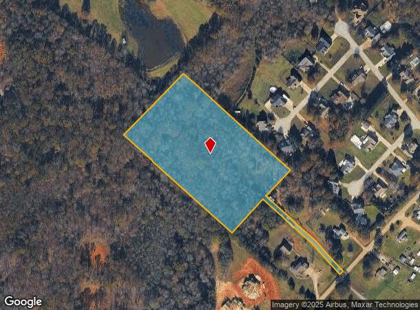
553 E Airport Rd
Greenville-Anderson-Greer, SC
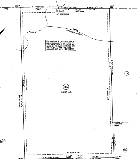
Summary Plat For Jacob A Jussila And Rob
0618.03-01-007.03
18D
Residentialacreage
Greenville
X
South Carolina
45045C0265E
007.03
2025
6.40 AC
2024
Travelers Rest
002405
Greenville/Spartanburg
DEMOGRAPHICS near 553 E Airport Rd
1 mile
3 mile
5 mile
2024 Total Population
1,931
13,810
43,839
2029 Population
2,141
15,409
48,972
Pop Growth 2024-2029
+ 10.88%
+ 11.58%
+ 11.71%
Average Age
41
40
41
2024 Total Households
702
5,123
16,875
HH Growth 2024-2029
+ 10.97%
+ 11.67%
+ 11.80%
Median Household Inc
$71,658
$80,454
$73,970
Avg Household Size
2.70
2.60
2.60
2024 Avg HH Vehicles
2.00
2.00
2.00
Median Home Value
$248,604
$256,331
$241,914
Median Year Built
2002
2002
1998
Nearby Places
Map Layers
Map Styles
 Street
 Aerial
Transit
 Traffic
 Biking
Places
Listings with unknown addresses are not visible on the map
- Restaurants
- Banks
- Shops
- Fitness
- Groceries
PUBLIC TRANSPORTATION
AIRPORT
Greenville Spartanburg International
Drive
Walk
Distance
Greenville Spartanburg International
29 min
12.4 mi
Freight Ports
North Charleston Terminal
Drive
Walk
Distance
North Charleston Terminal
248 min
210.0 mi
Nearby Properties
Address
Land Use
TOTAL SIZE
Lot Size
Zoning
Address
Land Use
TOTAL SIZE
Lot Size
Zoning
34.30 AC
UNZONED
Address
Land Use
TOTAL SIZE
Lot Size
Zoning
889 SF
2.20 AC
C4
Address
Land Use
TOTAL SIZE
Lot Size
Zoning
3,649 SF
16.04 AC
UNZONED
Address
Land Use
TOTAL SIZE
Lot Size
Zoning
70.66 AC
RS
Address
Land Use
TOTAL SIZE
Lot Size
Zoning
56.94 AC
Address
Land Use
TOTAL SIZE
Lot Size
Zoning
58.18 AC
UNZONED
Address
Land Use
TOTAL SIZE
Lot Size
Zoning
9,681 SF
2.79 AC
Address
Land Use
TOTAL SIZE
Lot Size
Zoning
4,216 SF
Address
Land Use
TOTAL SIZE
Lot Size
Zoning
2,164 SF
33.02 AC
Address
Land Use
TOTAL SIZE
Lot Size
Zoning
33.77 AC
UNZONED
Address
Land Use
TOTAL SIZE
Lot Size
Zoning
43.29 AC
UNZONED
Address
Land Use
TOTAL SIZE
Lot Size
Zoning
3,348 SF
1.55 AC
Address
Land Use
TOTAL SIZE
Lot Size
Zoning
3,013 SF
0.77 AC
UNZONED
Address
Land Use
TOTAL SIZE
Lot Size
Zoning
4,381 SF
0.62 AC
Address
Land Use
TOTAL SIZE
Lot Size
Zoning
720 SF
22.40 AC
RS
Address
Land Use
TOTAL SIZE
Lot Size
Zoning
22.10 AC
RS
Address
Land Use
TOTAL SIZE
Lot Size
Zoning
2,615 SF
0.54 AC
Address
Land Use
TOTAL SIZE
Lot Size
Zoning
21.14 AC
RS
Address
Land Use
TOTAL SIZE
Lot Size
Zoning
2,102 SF
0.48 AC
UNZONED
Address
Land Use
TOTAL SIZE
Lot Size
Zoning
2,818 SF
0.78 AC
Address
Land Use
TOTAL SIZE
Lot Size
Zoning
5.70 AC
UNZONED
Address
Land Use
TOTAL SIZE
Lot Size
Zoning
1,998 SF
15.77 AC
RS
Address
Land Use
TOTAL SIZE
Lot Size
Zoning
2,081 SF
0.28 AC
UNZONED
Address
Land Use
TOTAL SIZE
Lot Size
Zoning
13.86 AC
UNZONED
Address
Land Use
TOTAL SIZE
Lot Size
Zoning
1,890 SF
0.26 AC
R75
Address
Land Use
TOTAL SIZE
Lot Size
Zoning
19.80 AC
UNZONED
Address
Land Use
TOTAL SIZE
Lot Size
Zoning
29.50 AC
UNZONED
Address
Land Use
TOTAL SIZE
Lot Size
Zoning
2,382 SF
4.75 AC
UNZONED
Address
Land Use
TOTAL SIZE
Lot Size
Zoning
78 SF
46.23 AC
Address
Land Use
TOTAL SIZE
Lot Size
Zoning
1,620 SF
0.74 AC
UNZONED
The World's #1 Commercial Real Estate Marketplace
Connect with us
© 2026 CoStar Group
The information above has been obtained from sources believed reliable. While we do not doubt its accuracy we have not verified it and make no guarantee, warranty or representation about it. It is your responsibility to independently confirm its accuracy and completeness. Any projections, opinions, assumptions, or estimates used are for example only and do not represent the current or future performance of the property. The value of this transaction to you depends on tax and other factors which should be evaluated by your tax, financial, and legal advisors. You and your advisors should conduct a careful, independent investigation of the property to determine to your satisfaction the suitability of the property for your needs.