Property Record
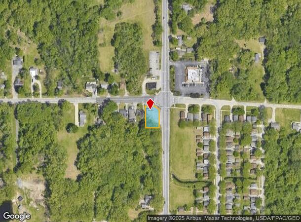
553 N Mccord Rd, Toledo, OH 43615
NEARBY LISTINGS FOR SALE OR LEASE
Property Detail
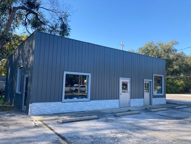
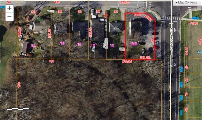
553 N Mccord Rd
65-00231
2 4 SE 1/4 N 164.21 FT ON W LINE OF E223.67 FT ON N LINE
Storebuilding
Lucas
AE
Ohio
39095C0064F
0.24 AC
2024
West/Sylvania
2024
Toledo
008601
Toledo, OH
1,200 SF
DEMOGRAPHICS near 553 N Mccord Rd
1 Mile
3 Mile
5 Mile
2024 Total Population
8,392
55,207
138,091
2029 Population
8,479
54,451
135,828
Pop Growth 2024-2029
+ 1.04%
(1.37%)
(1.64%)
Average Age
40
42
41
2024 Total Households
3,907
24,169
59,267
HH Growth 2024-2029
+ 1.61%
(1.24%)
(1.59%)
Median Household Inc
$57,805
$65,192
$64,105
Avg Household Size
2.10
2.20
2.20
2024 Avg HH Vehicles
2.00
2.00
2.00
Median Home Value
$146,482
$173,260
$187,984
Median Year Built
1984
1981
1977
Nearby Places
Map Layers
Map Styles
 Street
 Aerial
- Restaurants
- Banks
- Shops
- Fitness
- Groceries
PUBLIC TRANSPORTATION
COMMUTER RAIL
Toledo (Capitol Limited - Amtrak, Lake Shore Limited - Amtrak)
DRIVE
WALK
Distance
Toledo (Capitol Limited - Amtrak, Lake Shore Limited - Amtrak)
19 min
9.5 mi
AIRPORT
Eugene F Kranz Toledo Express
DRIVE
WALK
Distance
Eugene F Kranz Toledo Express
26 min
12.6 mi
Freight Ports
Port of Toledo
DRIVE
WALK
Distance
Port of Toledo
32 min
18.2 mi
SALE & LEASE HISTORY
LISTING DATE
SALE/LEASE

Dec 16, 2023
For Sale
Nearby Properties
Address
Land Use
TOTAL SIZE
Lot Size
Zoning
Address
Land Use
TOTAL SIZE
Lot Size
Zoning
329,064 SF
69.74 AC
10-RS6
Address
Land Use
TOTAL SIZE
Lot Size
Zoning
186,190 SF
14 AC
19-C2
Address
Land Use
TOTAL SIZE
Lot Size
Zoning
275,113 SF
21 AC
10-MX
Address
Land Use
TOTAL SIZE
Lot Size
Zoning
211,140 SF
28.92 AC
10-IC
Address
Land Use
TOTAL SIZE
Lot Size
Zoning
209,351 SF
49.06 AC
31-R1
Address
Land Use
TOTAL SIZE
Lot Size
Zoning
90,056 SF
10.17 AC
20-C2
Address
Land Use
TOTAL SIZE
Lot Size
Zoning
178,915 SF
13 AC
19-R3
Address
Land Use
TOTAL SIZE
Lot Size
Zoning
89,031 SF
15.83 AC
31-M2
Address
Land Use
TOTAL SIZE
Lot Size
Zoning
148,680 SF
8.50 AC
19-M3
Address
Land Use
TOTAL SIZE
Lot Size
Zoning
212,664 SF
21.43 AC
24-B3
Address
Land Use
TOTAL SIZE
Lot Size
Zoning
139,741 SF
30.48 AC
19-RA3
Address
Land Use
TOTAL SIZE
Lot Size
Zoning
200,639 SF
16.39 AC
24-SUP
Address
Land Use
TOTAL SIZE
Lot Size
Zoning
169,580 SF
8.98 AC
20-C2
Address
Land Use
TOTAL SIZE
Lot Size
Zoning
67,713 SF
10.24 AC
20-C2
Address
Land Use
TOTAL SIZE
Lot Size
Zoning
217,992 SF
39.78 AC
20-C2
Address
Land Use
TOTAL SIZE
Lot Size
Zoning
156,420 SF
12 AC
19-R3
Address
Land Use
TOTAL SIZE
Lot Size
Zoning
238,148 SF
18.20 AC
24-B3
Address
Land Use
TOTAL SIZE
Lot Size
Zoning
200,978 SF
13.15 AC
10-RD6
Address
Land Use
TOTAL SIZE
Lot Size
Zoning
111,195 SF
13.64 AC
19-C2
Address
Land Use
TOTAL SIZE
Lot Size
Zoning
120,077 SF
9.53 AC
24-B3
Address
Land Use
TOTAL SIZE
Lot Size
Zoning
214,400 SF
13.07 AC
20-C2
Address
Land Use
TOTAL SIZE
Lot Size
Zoning
90,782 SF
18.24 AC
20-RA
Address
Land Use
TOTAL SIZE
Lot Size
Zoning
126,732 SF
15 AC
10-CRSO
Address
Land Use
TOTAL SIZE
Lot Size
Zoning
140,008 SF
10 AC
19-R3
Address
Land Use
TOTAL SIZE
Lot Size
Zoning
36,153 SF
4.43 AC
20-C2
Address
Land Use
TOTAL SIZE
Lot Size
Zoning
113,835 SF
216.19 AC
10-RS6
Address
Land Use
TOTAL SIZE
Lot Size
Zoning
103,406 SF
7.55 AC
24-SUP
Address
Land Use
TOTAL SIZE
Lot Size
Zoning
218,603 SF
18 AC
10-MX
Address
Land Use
TOTAL SIZE
Lot Size
Zoning
81,676 SF
4 AC
19-C2
Address
Land Use
TOTAL SIZE
Lot Size
Zoning
60,805 SF
9.38 AC
10-RS12
The World's #1 Commercial Real Estate Marketplace
Connect with us
© 2025 CoStar Group
The information above has been obtained from sources believed reliable. While we do not doubt its accuracy we have not verified it and make no guarantee, warranty or representation about it. It is your responsibility to independently confirm its accuracy and completeness. Any projections, opinions, assumptions, or estimates used are for example only and do not represent the current or future performance of the property. The value of this transaction to you depends on tax and other factors which should be evaluated by your tax, financial, and legal advisors. You and your advisors should conduct a careful, independent investigation of the property to determine to your satisfaction the suitability of the property for your needs.