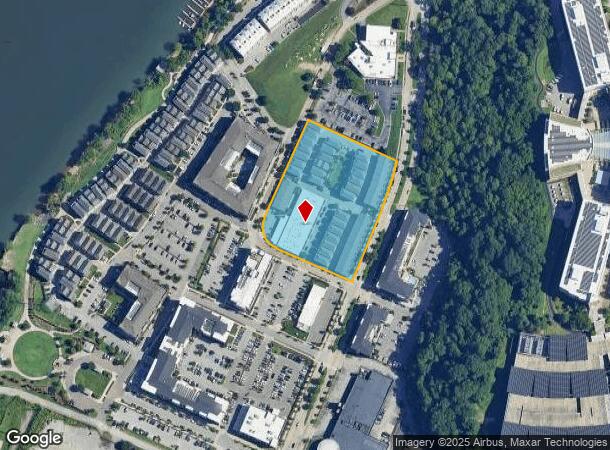
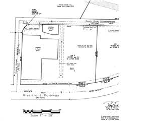
Property Record
553 Riverfront Pkwy, Chattanooga, TN 37402


NEARBY LISTINGS FOR SALE OR LEASE
Property Detail
553 Riverfront Pkwy
Chattanooga, TN-GA
Golden Gateway
135N-A-001
LT 1 DISTRICT AT CAMERON HARBOR PB 76 PG 88 REV 109-38
Highriseapartments
Hamilton
X
Tennessee
47065C0337G
1
2025
3.16 AC
2025
CBD
001600
Chattanooga
16,072 SF
DEMOGRAPHICS near 553 Riverfront Pkwy
1 Mile
3 Mile
5 Mile
2024 Total Population
6,984
43,748
111,535
2029 Population
7,704
47,590
120,300
Pop Growth 2024-2029
+ 10.31%
+ 8.78%
+ 7.86%
Average Age
42
37
38
2024 Total Households
4,254
20,502
48,266
HH Growth 2024-2029
+ 11.02%
+ 9.32%
+ 8.23%
Median Household Inc
$36,622
$56,585
$48,741
Avg Household Size
1.50
2.00
2.20
2024 Avg HH Vehicles
1.00
1.00
2.00
Median Home Value
$493,268
$331,157
$264,714
Median Year Built
2001
1982
1969
Nearby Places
Map Layers
Map Styles
 Street
 Aerial
- Restaurants
- Banks
- Shops
- Fitness
- Groceries
PUBLIC TRANSPORTATION
AIRPORT
Lovell Field
DRIVE
WALK
Distance
Lovell Field
20 min
10.7 mi
Freight Ports
Georgia Ports - Savannah
DRIVE
WALK
Distance
Georgia Ports - Savannah
410 min
365.9 mi
Nearby Properties
Address
Land Use
TOTAL SIZE
Lot Size
Zoning
Address
Land Use
TOTAL SIZE
Lot Size
Zoning
1,412,692 SF
1.74 AC
C3
Address
Land Use
TOTAL SIZE
Lot Size
Zoning
1,750,017 SF
31.32 AC
Address
Land Use
TOTAL SIZE
Lot Size
Zoning
603,035 SF
21.57 AC
C3
Address
Land Use
TOTAL SIZE
Lot Size
Zoning
6.35 AC
Address
Land Use
TOTAL SIZE
Lot Size
Zoning
252,201 SF
1.60 AC
C3
Address
Land Use
TOTAL SIZE
Lot Size
Zoning
293,884 SF
4.40 AC
Address
Land Use
TOTAL SIZE
Lot Size
Zoning
192,000 SF
3.09 AC
R4
Address
Land Use
TOTAL SIZE
Lot Size
Zoning
409,451 SF
2.53 AC
C3
Address
Land Use
TOTAL SIZE
Lot Size
Zoning
298,706 SF
1.18 AC
Address
Land Use
TOTAL SIZE
Lot Size
Zoning
91,908 SF
2.64 AC
C3
Address
Land Use
TOTAL SIZE
Lot Size
Zoning
552,237 SF
1.87 AC
Address
Land Use
TOTAL SIZE
Lot Size
Zoning
170,000 SF
2.25 AC
C3
Address
Land Use
TOTAL SIZE
Lot Size
Zoning
182,932 SF
3.67 AC
M1
Address
Land Use
TOTAL SIZE
Lot Size
Zoning
134,974 SF
3.22 AC
Address
Land Use
TOTAL SIZE
Lot Size
Zoning
306,411 SF
6.96 AC
Address
Land Use
TOTAL SIZE
Lot Size
Zoning
19.38 AC
M1
Address
Land Use
TOTAL SIZE
Lot Size
Zoning
351,776 SF
17.70 AC
R4
Address
Land Use
TOTAL SIZE
Lot Size
Zoning
308,635 SF
2.24 AC
M1
Address
Land Use
TOTAL SIZE
Lot Size
Zoning
105,125 SF
3.38 AC
Address
Land Use
TOTAL SIZE
Lot Size
Zoning
275,364 SF
16.86 AC
C2
Address
Land Use
TOTAL SIZE
Lot Size
Zoning
357,029 SF
13.45 AC
C3
Address
Land Use
TOTAL SIZE
Lot Size
Zoning
293,516 SF
5.12 AC
M1
Address
Land Use
TOTAL SIZE
Lot Size
Zoning
194,019 SF
1.46 AC
C3
Address
Land Use
TOTAL SIZE
Lot Size
Zoning
288,371 SF
9.39 AC
Address
Land Use
TOTAL SIZE
Lot Size
Zoning
96,222 SF
0.57 AC
C3
Address
Land Use
TOTAL SIZE
Lot Size
Zoning
171,906 SF
2.10 AC
C2
Address
Land Use
TOTAL SIZE
Lot Size
Zoning
291,600 SF
1.32 AC
Address
Land Use
TOTAL SIZE
Lot Size
Zoning
175,260 SF
2.75 AC
C3
Address
Land Use
TOTAL SIZE
Lot Size
Zoning
75,697 SF
1.33 AC
Address
Land Use
TOTAL SIZE
Lot Size
Zoning
432,056 SF
2.54 AC
C3
The World's #1 Commercial Real Estate Marketplace
Connect with us
© 2026 CoStar Group
The information above has been obtained from sources believed reliable. While we do not doubt its accuracy we have not verified it and make no guarantee, warranty or representation about it. It is your responsibility to independently confirm its accuracy and completeness. Any projections, opinions, assumptions, or estimates used are for example only and do not represent the current or future performance of the property. The value of this transaction to you depends on tax and other factors which should be evaluated by your tax, financial, and legal advisors. You and your advisors should conduct a careful, independent investigation of the property to determine to your satisfaction the suitability of the property for your needs.