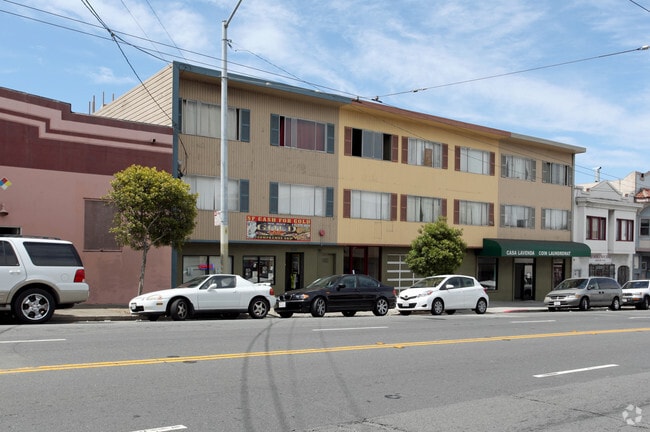
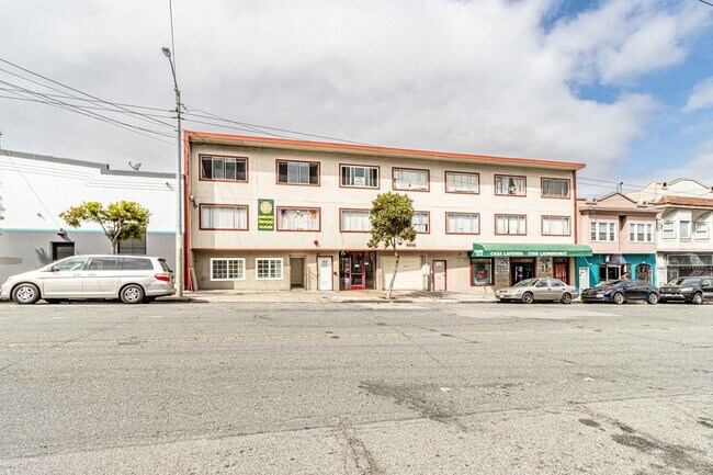
Property Record
5530 Mission St, San Francisco, CA 94112

Current Lease Availabilities
NEARBY LISTINGS FOR SALE OR LEASE
Property Detail
5530 Mission St
San Francisco
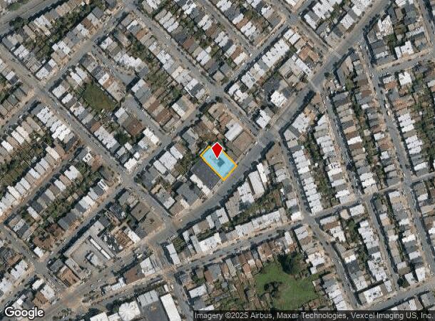
West End Map #2
San Francisco-Redwood City-South San Francisco, CA
BLK 24 LOT 3
7066-033
San Francisco
Apartment
California
2024
33
2025
0.27 AC
026202
Outer Mission
15,240 SF
DEMOGRAPHICS near 5530 Mission St
1 Mile
3 Mile
5 Mile
2024 Total Population
52,867
292,229
716,413
2029 Population
47,708
268,868
664,413
Pop Growth 2024-2029
(9.76%)
(7.99%)
(7.26%)
Average Age
43
43
42
2024 Total Households
14,811
97,101
264,776
HH Growth 2024-2029
(10.18%)
(8.30%)
(7.62%)
Median Household Inc
$103,311
$119,760
$125,399
Avg Household Size
3.40
2.90
2.60
2024 Avg HH Vehicles
2.00
2.00
1.00
Median Home Value
$1,028,965
$1,078,843
$1,081,044
Median Year Built
1949
1952
1952
Nearby Places
Map Layers
Map Styles
 Street
 Aerial
- Restaurants
- Banks
- Shops
- Fitness
- Groceries
PUBLIC TRANSPORTATION
COMMUTER RAIL
DRIVE
WALK
Distance
9 min
3.3 mi
22nd Street (Caltrain - Caltrain (Caltrain))
DRIVE
WALK
Distance
22nd Street (Caltrain - Caltrain (Caltrain))
11 min
5.9 mi
AIRPORT
San Francisco International
DRIVE
WALK
Distance
San Francisco International
20 min
11.8 mi
Metro Oakland International
DRIVE
WALK
Distance
Metro Oakland International
39 min
26.0 mi
Freight Ports
Port of San Francisco
DRIVE
WALK
Distance
Port of San Francisco
16 min
9.4 mi
Nearby Properties
Address
Land Use
TOTAL SIZE
Lot Size
Zoning
Address
Land Use
TOTAL SIZE
Lot Size
Zoning
248,303 SF
4.35 AC
Address
Land Use
TOTAL SIZE
Lot Size
Zoning
411,904 SF
21.74 AC
C2
Address
Land Use
TOTAL SIZE
Lot Size
Zoning
346,710 SF
7.45 AC
RH2
Address
Land Use
TOTAL SIZE
Lot Size
Zoning
312,191 SF
2.74 AC
Address
Land Use
TOTAL SIZE
Lot Size
Zoning
54,000 SF
1.67 AC
PDR2
Address
Land Use
TOTAL SIZE
Lot Size
Zoning
42.95 AC
Address
Land Use
TOTAL SIZE
Lot Size
Zoning
447,674 SF
21.51 AC
Address
Land Use
TOTAL SIZE
Lot Size
Zoning
439,294 SF
5.43 AC
PDR2
Address
Land Use
TOTAL SIZE
Lot Size
Zoning
143,920 SF
7.29 AC
PDR2
Address
Land Use
TOTAL SIZE
Lot Size
Zoning
183,284 SF
6.85 AC
PD0000
Address
Land Use
TOTAL SIZE
Lot Size
Zoning
2.03 AC
C2
Address
Land Use
TOTAL SIZE
Lot Size
Zoning
88,900 SF
5.37 AC
NCS
Address
Land Use
TOTAL SIZE
Lot Size
Zoning
11.31 AC
RM2
Address
Land Use
TOTAL SIZE
Lot Size
Zoning
160,983 SF
1.84 AC
NC2
Address
Land Use
TOTAL SIZE
Lot Size
Zoning
1.33 AC
M1
Address
Land Use
TOTAL SIZE
Lot Size
Zoning
279,560 SF
13.24 AC
M10000
Address
Land Use
TOTAL SIZE
Lot Size
Zoning
10.62 AC
Address
Land Use
TOTAL SIZE
Lot Size
Zoning
160,000 SF
1.27 AC
C2
Address
Land Use
TOTAL SIZE
Lot Size
Zoning
Address
Land Use
TOTAL SIZE
Lot Size
Zoning
95,469 SF
3.68 AC
RH-1
Address
Land Use
TOTAL SIZE
Lot Size
Zoning
2,011 SF
2.49 AC
Address
Land Use
TOTAL SIZE
Lot Size
Zoning
73,491 SF
4.48 AC
C2
Address
Land Use
TOTAL SIZE
Lot Size
Zoning
12,555 SF
0.74 AC
NCS
Address
Land Use
TOTAL SIZE
Lot Size
Zoning
176,000 SF
1.64 AC
C2
Address
Land Use
TOTAL SIZE
Lot Size
Zoning
3.77 AC
Address
Land Use
TOTAL SIZE
Lot Size
Zoning
54,131 SF
1.75 AC
C2
Address
Land Use
TOTAL SIZE
Lot Size
Zoning
6.87 AC
RH2
Address
Land Use
TOTAL SIZE
Lot Size
Zoning
107,362 SF
5.74 AC
M1
Address
Land Use
TOTAL SIZE
Lot Size
Zoning
181,172 SF
2.11 AC
Address
Land Use
TOTAL SIZE
Lot Size
Zoning
73,966 SF
4 AC
M10000
The World's #1 Commercial Real Estate Marketplace
Connect with us
© 2026 CoStar Group
The information above has been obtained from sources believed reliable. While we do not doubt its accuracy we have not verified it and make no guarantee, warranty or representation about it. It is your responsibility to independently confirm its accuracy and completeness. Any projections, opinions, assumptions, or estimates used are for example only and do not represent the current or future performance of the property. The value of this transaction to you depends on tax and other factors which should be evaluated by your tax, financial, and legal advisors. You and your advisors should conduct a careful, independent investigation of the property to determine to your satisfaction the suitability of the property for your needs.