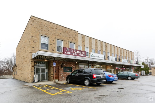
Property Record
5555 Wilson Mills Rd, Cleveland, OH 44143
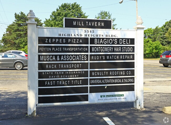
Current Lease Availabilities
NEARBY LISTINGS FOR SALE OR LEASE
Property Detail
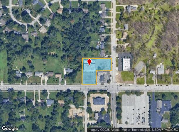
5555 Wilson Mills Rd
Cleveland-Elyria, OH
Mayfield 01
822-12-036
TR 1-41 0001
Storesoffices
Cuyahoga
X
Ohio
39035C0111E
1
2024
1.50 AC
2024
Northeast
155102
Cleveland
18,240 SF
DEMOGRAPHICS near 5555 Wilson Mills Rd
1 Mile
3 Mile
5 Mile
2024 Total Population
7,907
76,059
201,807
2029 Population
7,641
74,488
197,935
Pop Growth 2024-2029
(3.36%)
(2.07%)
(1.92%)
Average Age
44
44
42
2024 Total Households
3,215
34,295
88,269
HH Growth 2024-2029
(3.64%)
(2.07%)
(2.00%)
Median Household Inc
$86,706
$69,579
$59,243
Avg Household Size
2.40
2.10
2.20
2024 Avg HH Vehicles
2.00
2.00
2.00
Median Home Value
$209,823
$181,030
$170,312
Median Year Built
1958
1963
1957
Nearby Places
- Restaurants
- Banks
- Shops
- Fitness
- Groceries
PUBLIC TRANSPORTATION
AIRPORT
Cleveland-Hopkins International
DRIVE
WALK
Distance
Cleveland-Hopkins International
42 min
28.2 mi
Nearby Properties
Address
Land Use
TOTAL SIZE
Lot Size
Zoning
Address
Land Use
TOTAL SIZE
Lot Size
Zoning
1,089,649 SF
12.22 AC
U-8
Address
Land Use
TOTAL SIZE
Lot Size
Zoning
964,082 SF
40.67 AC
Address
Land Use
TOTAL SIZE
Lot Size
Zoning
650,536 SF
19.01 AC
U-3A
Address
Land Use
TOTAL SIZE
Lot Size
Zoning
379,326 SF
43.45 AC
CRG
Address
Land Use
TOTAL SIZE
Lot Size
Zoning
1,478,659 SF
50.49 AC
IG
Address
Land Use
TOTAL SIZE
Lot Size
Zoning
347,464 SF
11.64 AC
U-8
Address
Land Use
TOTAL SIZE
Lot Size
Zoning
592,100 SF
27.58 AC
U-3B
Address
Land Use
TOTAL SIZE
Lot Size
Zoning
157,311 SF
8.95 AC
U-1A
Address
Land Use
TOTAL SIZE
Lot Size
Zoning
302,009 SF
6.62 AC
U-7A
Address
Land Use
TOTAL SIZE
Lot Size
Zoning
384,659 SF
20.20 AC
U-4A
Address
Land Use
TOTAL SIZE
Lot Size
Zoning
106,995 SF
9.62 AC
CRG
Address
Land Use
TOTAL SIZE
Lot Size
Zoning
378,218 SF
29.34 AC
Address
Land Use
TOTAL SIZE
Lot Size
Zoning
386,904 SF
8.33 AC
U-3B
Address
Land Use
TOTAL SIZE
Lot Size
Zoning
252,759 SF
27.66 AC
R-1
Address
Land Use
TOTAL SIZE
Lot Size
Zoning
1,520,349 SF
20.39 AC
IR
Address
Land Use
TOTAL SIZE
Lot Size
Zoning
190,745 SF
11.70 AC
U-3C
Address
Land Use
TOTAL SIZE
Lot Size
Zoning
304,615 SF
20.60 AC
U-7
Address
Land Use
TOTAL SIZE
Lot Size
Zoning
445,625 SF
35.92 AC
U-7
Address
Land Use
TOTAL SIZE
Lot Size
Zoning
92,442 SF
159.84 AC
I-1
Address
Land Use
TOTAL SIZE
Lot Size
Zoning
12,067 SF
582.06 AC
U-1
Address
Land Use
TOTAL SIZE
Lot Size
Zoning
166,392 SF
36.46 AC
RMF-2
Address
Land Use
TOTAL SIZE
Lot Size
Zoning
349,220 SF
20.03 AC
U-7
Address
Land Use
TOTAL SIZE
Lot Size
Zoning
91,540 SF
14.35 AC
CRG
Address
Land Use
TOTAL SIZE
Lot Size
Zoning
484,769 SF
12.21 AC
U-3A
Address
Land Use
TOTAL SIZE
Lot Size
Zoning
224,140 SF
3.09 AC
U-8
Address
Land Use
TOTAL SIZE
Lot Size
Zoning
71,850 SF
2.58 AC
U-8
Address
Land Use
TOTAL SIZE
Lot Size
Zoning
189,444 SF
9.71 AC
U-5
Address
Land Use
TOTAL SIZE
Lot Size
Zoning
347,392 SF
11.29 AC
U-8
Address
Land Use
TOTAL SIZE
Lot Size
Zoning
190,580 SF
7.90 AC
P.F.
Address
Land Use
TOTAL SIZE
Lot Size
Zoning
65,612 SF
6.01 AC
U-4
The World's #1 Commercial Real Estate Marketplace
Connect with us
© 2025 CoStar Group
The information above has been obtained from sources believed reliable. While we do not doubt its accuracy we have not verified it and make no guarantee, warranty or representation about it. It is your responsibility to independently confirm its accuracy and completeness. Any projections, opinions, assumptions, or estimates used are for example only and do not represent the current or future performance of the property. The value of this transaction to you depends on tax and other factors which should be evaluated by your tax, financial, and legal advisors. You and your advisors should conduct a careful, independent investigation of the property to determine to your satisfaction the suitability of the property for your needs.