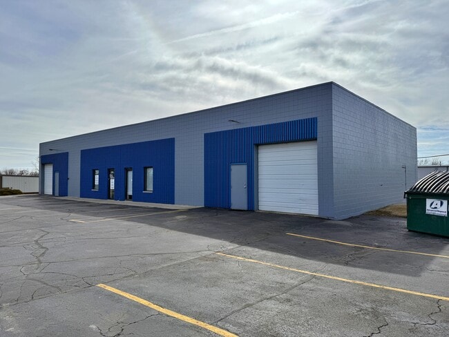
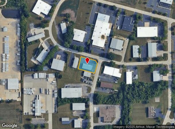
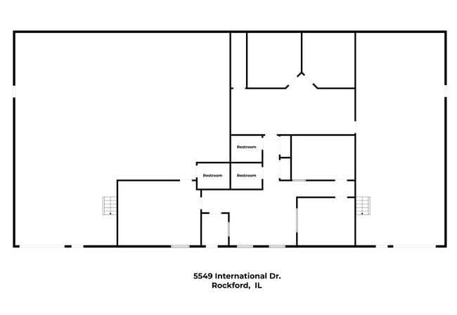
Property Record
5549 International Dr, Rockford, IL 61109
Current Lease Availabilities
NEARBY LISTINGS FOR SALE OR LEASE
Property Detail
5549 International Dr
Rockford, IL
Sandy Hollow Industrial Park
16-04-452-003
SANDY HOLLOW INDUSTRIAL PARK BNG SUB OF PT SW1/4 & PT SE1/4 SEC 4-43-2 LOT 14
Industrialgeneral
Winnebago
X
Illinois
17141C0150D
14
2024
0.50 AC
2024
I-39 Cor/Winnebago Cy
003708
Chicago
5,000 SF
DEMOGRAPHICS near 5549 International Dr
1 Mile
3 Mile
5 Mile
2024 Total Population
3,645
45,880
106,186
2029 Population
3,576
45,230
104,898
Pop Growth 2024-2029
(1.89%)
(1.42%)
(1.21%)
Average Age
39
40
40
2024 Total Households
1,596
18,596
43,475
HH Growth 2024-2029
(1.69%)
(1.36%)
(1.19%)
Median Household Inc
$59,171
$55,878
$53,447
Avg Household Size
2.30
2.40
2.40
2024 Avg HH Vehicles
2.00
2.00
2.00
Median Home Value
$151,655
$133,470
$130,485
Median Year Built
1978
1973
1967
Nearby Places
- Restaurants
- Banks
- Shops
- Fitness
- Groceries
PUBLIC TRANSPORTATION
AIRPORT
Chicago/Rockford International
DRIVE
WALK
Distance
Chicago/Rockford International
19 min
9.1 mi
Freight Ports
Port Milwaukee
DRIVE
WALK
Distance
Port Milwaukee
113 min
94.9 mi
Nearby Properties
Address
Land Use
TOTAL SIZE
Lot Size
Zoning
Address
Land Use
TOTAL SIZE
Lot Size
Zoning
559,880 SF
56.87 AC
CC
Address
Land Use
TOTAL SIZE
Lot Size
Zoning
302,569 SF
24.58 AC
C2
Address
Land Use
TOTAL SIZE
Lot Size
Zoning
680,704 SF
43.11 AC
R3
Address
Land Use
TOTAL SIZE
Lot Size
Zoning
920,723 SF
82.07 AC
Address
Land Use
TOTAL SIZE
Lot Size
Zoning
551,795 SF
36 AC
R3
Address
Land Use
TOTAL SIZE
Lot Size
Zoning
138,658 SF
12.91 AC
C2
Address
Land Use
TOTAL SIZE
Lot Size
Zoning
217,520 SF
13.82 AC
C3
Address
Land Use
TOTAL SIZE
Lot Size
Zoning
96,130 SF
12.47 AC
R2
Address
Land Use
TOTAL SIZE
Lot Size
Zoning
73,031 SF
10.23 AC
C1
Address
Land Use
TOTAL SIZE
Lot Size
Zoning
147,900 SF
7.78 AC
Address
Land Use
TOTAL SIZE
Lot Size
Zoning
84,569 SF
4 AC
C3
Address
Land Use
TOTAL SIZE
Lot Size
Zoning
77,718 SF
11.12 AC
C2
Address
Land Use
TOTAL SIZE
Lot Size
Zoning
199,330 SF
15.02 AC
CG
Address
Land Use
TOTAL SIZE
Lot Size
Zoning
136,530 SF
4 AC
R4
Address
Land Use
TOTAL SIZE
Lot Size
Zoning
86,970 SF
14.88 AC
CG
Address
Land Use
TOTAL SIZE
Lot Size
Zoning
104,000 SF
14.15 AC
C3
Address
Land Use
TOTAL SIZE
Lot Size
Zoning
145,014 SF
12.06 AC
CC
Address
Land Use
TOTAL SIZE
Lot Size
Zoning
174,318 SF
17.97 AC
Address
Land Use
TOTAL SIZE
Lot Size
Zoning
133,394 SF
14.08 AC
C3
Address
Land Use
TOTAL SIZE
Lot Size
Zoning
31,898 SF
C2
Address
Land Use
TOTAL SIZE
Lot Size
Zoning
66,228 SF
5.08 AC
C1
Address
Land Use
TOTAL SIZE
Lot Size
Zoning
122,369 SF
10.57 AC
C2
Address
Land Use
TOTAL SIZE
Lot Size
Zoning
86,720 SF
3.91 AC
R4
Address
Land Use
TOTAL SIZE
Lot Size
Zoning
61,199 SF
3.04 AC
R3
Address
Land Use
TOTAL SIZE
Lot Size
Zoning
10,970 SF
26.80 AC
R2
Address
Land Use
TOTAL SIZE
Lot Size
Zoning
111,311 SF
7.85 AC
I1
Address
Land Use
TOTAL SIZE
Lot Size
Zoning
128,066 SF
4.15 AC
CC
Address
Land Use
TOTAL SIZE
Lot Size
Zoning
41,388 SF
6.90 AC
R3
Address
Land Use
TOTAL SIZE
Lot Size
Zoning
10.92 AC
Address
Land Use
TOTAL SIZE
Lot Size
Zoning
146,148 SF
1.14 AC
CC
The World's #1 Commercial Real Estate Marketplace
Connect with us
© 2025 CoStar Group
The information above has been obtained from sources believed reliable. While we do not doubt its accuracy we have not verified it and make no guarantee, warranty or representation about it. It is your responsibility to independently confirm its accuracy and completeness. Any projections, opinions, assumptions, or estimates used are for example only and do not represent the current or future performance of the property. The value of this transaction to you depends on tax and other factors which should be evaluated by your tax, financial, and legal advisors. You and your advisors should conduct a careful, independent investigation of the property to determine to your satisfaction the suitability of the property for your needs.