Property Record
555 1/2 Highway 50, Grand Junction, CO 81503
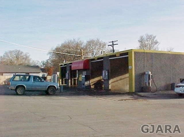
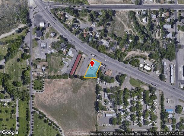
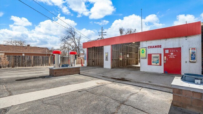
This Property Is For Sale
Property Detail
555 1/2 Highway 50
Grand Junction, CO
Fairley Add
R071699
BEG NE COR LOT 4 BLK 5 FAIRLEY ADD S 24DEG59 W 119.55 FT S 61DEG51 E 25FT S 24DEG59 W 30FT S 89DEG35 W TO A POINT ON S LI BLK 4 WHERE LOT LI COMMON TO LOTS 5 + 6 BLK 5 INTERSECTS S LI BLK 4 NELY TO N LOT COR COMMON TO LOTS 5 + 6 SELY ALG HWY TO BEG
Commercialnec
Mesa
X
Colorado
08077C0812F
4
2023
0.39 AC
2024
Colorado Northwest Area
001303
Other Market Areas
2,368 SF
NEARBY LISTINGS FOR SALE OR LEASE
-
-
View all Grand Junction listings for sale on LoopNet.com
DEMOGRAPHICS near 555 1/2 Highway 50
1 mile
3 mile
5 mile
2024 Total Population
4,068
37,987
89,869
2029 Population
4,259
39,747
94,456
Pop Growth 2024-2029
+ 4.70%
+ 4.63%
+ 5.10%
Average Age
40
40
42
2024 Total Households
1,764
15,747
37,452
HH Growth 2024-2029
+ 4.76%
+ 4.79%
+ 5.24%
Median Household Inc
$53,040
$53,964
$59,788
Avg Household Size
2.30
2.20
2.20
2024 Avg HH Vehicles
2.00
2.00
2.00
Median Home Value
$330,188
$288,814
$319,709
Median Year Built
1985
1974
1984
Nearby Places
Map Layers
Map Styles
 Street
 Aerial
Transit
 Traffic
 Biking
Places
Listings with unknown addresses are not visible on the map
- Restaurants
- Banks
- Shops
- Fitness
- Groceries
PUBLIC TRANSPORTATION
COMMUTER RAIL
Drive
Walk
Distance
4 min
1.8 mi
AIRPORT
Grand Junction Regional
Drive
Walk
Distance
Grand Junction Regional
15 min
6.5 mi
Nearby Properties
Address
Land Use
TOTAL SIZE
Lot Size
Zoning
Address
Land Use
TOTAL SIZE
Lot Size
Zoning
365,495 SF
20.90 AC
CSR
Address
Land Use
TOTAL SIZE
Lot Size
Zoning
482,392 SF
24.70 AC
CSR
Address
Land Use
TOTAL SIZE
Lot Size
Zoning
429,786 SF
16.99 AC
CSR
Address
Land Use
TOTAL SIZE
Lot Size
Zoning
444,676 SF
29.47 AC
CSR
Address
Land Use
TOTAL SIZE
Lot Size
Zoning
181,976 SF
14.80 AC
CSR
Address
Land Use
TOTAL SIZE
Lot Size
Zoning
180,396 SF
17.75 AC
CSR
Address
Land Use
TOTAL SIZE
Lot Size
Zoning
227,855 SF
37.91 AC
Address
Land Use
TOTAL SIZE
Lot Size
Zoning
75,770 SF
82.62 AC
CSR
Address
Land Use
TOTAL SIZE
Lot Size
Zoning
130,260 SF
0.20 AC
C-1
Address
Land Use
TOTAL SIZE
Lot Size
Zoning
127,269 SF
3.21 AC
B-2
Address
Land Use
TOTAL SIZE
Lot Size
Zoning
113,925 SF
0.16 AC
PD
Address
Land Use
TOTAL SIZE
Lot Size
Zoning
69,390 SF
0.14 AC
C-1
Address
Land Use
TOTAL SIZE
Lot Size
Zoning
94,639 SF
0.16 AC
C-1
Address
Land Use
TOTAL SIZE
Lot Size
Zoning
126,114 SF
13.75 AC
B-2
Address
Land Use
TOTAL SIZE
Lot Size
Zoning
66,178 SF
2.02 AC
PD
Address
Land Use
TOTAL SIZE
Lot Size
Zoning
86,946 SF
5.52 AC
C-1
Address
Land Use
TOTAL SIZE
Lot Size
Zoning
83,518 SF
1.45 AC
CSR
Address
Land Use
TOTAL SIZE
Lot Size
Zoning
70,394 SF
6.19 AC
PD
Address
Land Use
TOTAL SIZE
Lot Size
Zoning
215,583 SF
20.40 AC
C-1
Address
Land Use
TOTAL SIZE
Lot Size
Zoning
85,303 SF
8.45 AC
C-2
Address
Land Use
TOTAL SIZE
Lot Size
Zoning
87,806 SF
0.11 AC
Address
Land Use
TOTAL SIZE
Lot Size
Zoning
33,450 SF
86.40 AC
PUD
Address
Land Use
TOTAL SIZE
Lot Size
Zoning
164,850 SF
13.33 AC
C-1
Address
Land Use
TOTAL SIZE
Lot Size
Zoning
45,000 SF
0.20 AC
Address
Land Use
TOTAL SIZE
Lot Size
Zoning
91,623 SF
2.33 AC
B-2
Address
Land Use
TOTAL SIZE
Lot Size
Zoning
142,425 SF
19.91 AC
C-2
Address
Land Use
TOTAL SIZE
Lot Size
Zoning
68,700 SF
0.16 AC
Address
Land Use
TOTAL SIZE
Lot Size
Zoning
49,222 SF
15 AC
Address
Land Use
TOTAL SIZE
Lot Size
Zoning
47,598 SF
2.70 AC
B-1
The World's #1 Commercial Real Estate Marketplace
Connect with us
© 2026 CoStar Group
The information above has been obtained from sources believed reliable. While we do not doubt its accuracy we have not verified it and make no guarantee, warranty or representation about it. It is your responsibility to independently confirm its accuracy and completeness. Any projections, opinions, assumptions, or estimates used are for example only and do not represent the current or future performance of the property. The value of this transaction to you depends on tax and other factors which should be evaluated by your tax, financial, and legal advisors. You and your advisors should conduct a careful, independent investigation of the property to determine to your satisfaction the suitability of the property for your needs.