Property Record
555 19Th Ave, Moline, IL 61265
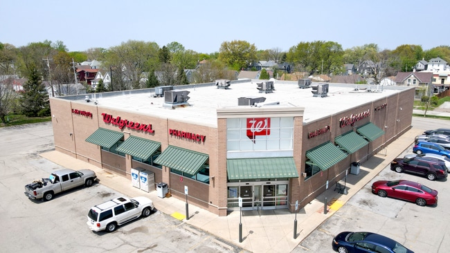

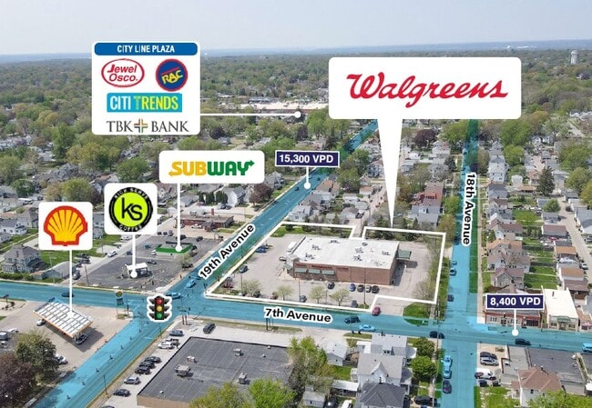
This Property Is For Sale
Property Detail
555 19Th Ave
17-06-235-026
SUPVR ASST MAP LOT 253 SHEET 8
Commercialnec
Rock Island
MOL
Illinois
B and X Area of moderate flood hazard, usually the area between the limits of the 100-year and 500-year floods.
253
2024
1.69 AC
2024
Greater Rock Island
022200
Davenport/Moline/Rock Island
14,392 SF
Davenport-Moline-Rock Island, IA-IL
NEARBY LISTINGS FOR SALE OR LEASE
DEMOGRAPHICS near 555 19Th Ave
1 mile
3 mile
5 mile
2025 Total Population
16,021
70,148
168,584
2030 Population
15,846
70,125
169,342
Pop Growth 2025-2030
(1.09%)
(0.03%)
+ 0.45%
Average Age
40
40
40
2025 Total Households
6,775
29,861
71,879
HH Growth 2025-2030
(1.15%)
(0.02%)
+ 0.52%
Median Household Inc
$58,789
$60,301
$62,943
Avg Household Size
2.30
2.20
2.20
2025 Avg HH Vehicles
2.00
2.00
2.00
Median Home Value
$135,596
$148,162
$159,290
Median Year Built
1947
1949
1955
Nearby Places
Map Layers
Map Styles
 Street
 Aerial
Layers
 Traffic
 Biking
Places
Listings with unknown addresses are not visible on the map
- Restaurants
- Banks
- Shops
- Fitness
- Groceries
PUBLIC TRANSPORTATION
AIRPORT
Quad Cities International
Drive
Walk
Distance
Quad Cities International
12 min
5.1 mi
Nearby Properties
Address
Land Use
TOTAL SIZE
Lot Size
Zoning
Address
Land Use
TOTAL SIZE
Lot Size
Zoning
157,798 SF
25.37 AC
Address
Land Use
TOTAL SIZE
Lot Size
Zoning
190,832 SF
3.88 AC
Address
Land Use
TOTAL SIZE
Lot Size
Zoning
76,808 SF
1.94 AC
Address
Land Use
TOTAL SIZE
Lot Size
Zoning
9,658 SF
8.07 AC
Address
Land Use
TOTAL SIZE
Lot Size
Zoning
65,958 SF
15.04 AC
Address
Land Use
TOTAL SIZE
Lot Size
Zoning
159,973 SF
0.87 AC
Address
Land Use
TOTAL SIZE
Lot Size
Zoning
61,126 SF
1.57 AC
Address
Land Use
TOTAL SIZE
Lot Size
Zoning
40,307 SF
1.25 AC
Address
Land Use
TOTAL SIZE
Lot Size
Zoning
67,439 SF
2.02 AC
Address
Land Use
TOTAL SIZE
Lot Size
Zoning
133,712 SF
2.31 AC
Address
Land Use
TOTAL SIZE
Lot Size
Zoning
4.30 AC
RI
Address
Land Use
TOTAL SIZE
Lot Size
Zoning
7.86 AC
Address
Land Use
TOTAL SIZE
Lot Size
Zoning
28,292 SF
3.76 AC
Address
Land Use
TOTAL SIZE
Lot Size
Zoning
122,806 SF
6.25 AC
Address
Land Use
TOTAL SIZE
Lot Size
Zoning
5,816 SF
6.87 AC
Address
Land Use
TOTAL SIZE
Lot Size
Zoning
108,500 SF
2.41 AC
MOL
Address
Land Use
TOTAL SIZE
Lot Size
Zoning
3,916 SF
9.30 AC
Address
Land Use
TOTAL SIZE
Lot Size
Zoning
13,440 SF
15.87 AC
Address
Land Use
TOTAL SIZE
Lot Size
Zoning
8.16 AC
MOL
Address
Land Use
TOTAL SIZE
Lot Size
Zoning
100,500 SF
0.94 AC
MOL
Address
Land Use
TOTAL SIZE
Lot Size
Zoning
1,287,769 SF
53.54 AC
MOL
Address
Land Use
TOTAL SIZE
Lot Size
Zoning
50,853 SF
1.29 AC
Address
Land Use
TOTAL SIZE
Lot Size
Zoning
2,744 SF
10.25 AC
Address
Land Use
TOTAL SIZE
Lot Size
Zoning
44,839 SF
10.86 AC
RI
Address
Land Use
TOTAL SIZE
Lot Size
Zoning
9,325 SF
12.38 AC
Address
Land Use
TOTAL SIZE
Lot Size
Zoning
369,922 SF
3.14 AC
RI
Address
Land Use
TOTAL SIZE
Lot Size
Zoning
35,972 SF
2.98 AC
Address
Land Use
TOTAL SIZE
Lot Size
Zoning
24,799 SF
0.42 AC
Address
Land Use
TOTAL SIZE
Lot Size
Zoning
6.53 AC
MOL
The World's #1 Commercial Real Estate Marketplace
Connect with us
© 2026 CoStar Group
The information above has been obtained from sources believed reliable. While we do not doubt its accuracy we have not verified it and make no guarantee, warranty or representation about it. It is your responsibility to independently confirm its accuracy and completeness. Any projections, opinions, assumptions, or estimates used are for example only and do not represent the current or future performance of the property. The value of this transaction to you depends on tax and other factors which should be evaluated by your tax, financial, and legal advisors. You and your advisors should conduct a careful, independent investigation of the property to determine to your satisfaction the suitability of the property for your needs.