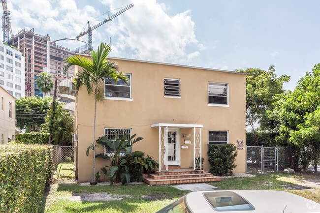
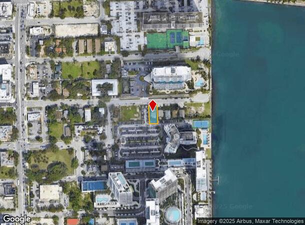
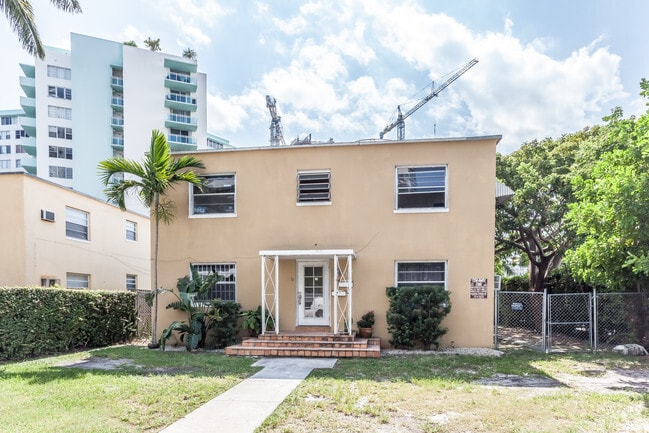
Property Record
560 Ne 34Th St, Miami, FL 33137
NEARBY LISTINGS FOR SALE OR LEASE
Property Detail
560 Ne 34Th St
Miami-Miami Beach-Kendall, FL
Beverly Point
01-3230-008-0030
BEVERLY POINT PB 30-12 LOT 3 LESS W10FT & W10FT OF LOT 4 LOT SIZE 50.000 X 110 OR 18053-0133 0398 1
Commercialacreage
Miami/Dade
AE
Florida
12086C0316L
3,4
2024
0.13 AC
2025
Edgewater
002705
South Florida
3,040 SF
DEMOGRAPHICS near 560 Ne 34Th St
1 Mile
3 Mile
5 Mile
2024 Total Population
33,858
227,504
546,554
2029 Population
34,824
228,157
544,906
Pop Growth 2024-2029
+ 2.85%
+ 0.29%
(0.30%)
Average Age
38
39
41
2024 Total Households
17,040
100,041
234,524
HH Growth 2024-2029
+ 2.65%
+ 0.31%
(0.17%)
Median Household Inc
$73,867
$51,752
$53,096
Avg Household Size
1.90
2.10
2.20
2024 Avg HH Vehicles
1.00
1.00
1.00
Median Home Value
$468,089
$454,748
$443,836
Median Year Built
2007
1994
1976
Nearby Places
- Restaurants
- Banks
- Shops
- Fitness
- Groceries
PUBLIC TRANSPORTATION
COMMUTER RAIL
Allapattah (Metrorail Green Line - Miami-Dade Transit (Metrorail/Metromover))
DRIVE
WALK
Distance
Allapattah (Metrorail Green Line - Miami-Dade Transit (Metrorail/Metromover))
7 min
2.4 mi
Santa Clara (Metrorail Green Line - Miami-Dade Transit (Metrorail/Metromover))
DRIVE
WALK
Distance
Santa Clara (Metrorail Green Line - Miami-Dade Transit (Metrorail/Metromover))
7 min
2.7 mi
AIRPORT
Miami International
DRIVE
WALK
Distance
Miami International
22 min
10.1 mi
Fort Lauderdale/Hollywood International
DRIVE
WALK
Distance
Fort Lauderdale/Hollywood International
32 min
21.9 mi
Freight Ports
Port of Miami
DRIVE
WALK
Distance
Port of Miami
11 min
4.1 mi
Nearby Properties
Address
Land Use
TOTAL SIZE
Lot Size
Zoning
Address
Land Use
TOTAL SIZE
Lot Size
Zoning
1,050,691 SF
0.83 AC
6408
Address
Land Use
TOTAL SIZE
Lot Size
Zoning
4,758,614 SF
810.91 AC
8000
Address
Land Use
TOTAL SIZE
Lot Size
Zoning
955,966 SF
38.91 AC
9600
Address
Land Use
TOTAL SIZE
Lot Size
Zoning
2,039,308 SF
2.46 AC
6401
Address
Land Use
TOTAL SIZE
Lot Size
Zoning
928,000 SF
14.30 AC
8000
Address
Land Use
TOTAL SIZE
Lot Size
Zoning
1,110,657 SF
3.83 AC
6407
Address
Land Use
TOTAL SIZE
Lot Size
Zoning
16.13 AC
6100
Address
Land Use
TOTAL SIZE
Lot Size
Zoning
1,346,294 SF
1.89 AC
6408
Address
Land Use
TOTAL SIZE
Lot Size
Zoning
2,403,353 SF
7.37 AC
6100
Address
Land Use
TOTAL SIZE
Lot Size
Zoning
1,938,271 SF
6.62 AC
6402
Address
Land Use
TOTAL SIZE
Lot Size
Zoning
1,075,124 SF
1.61 AC
6405
Address
Land Use
TOTAL SIZE
Lot Size
Zoning
1,544,491 SF
0.97 AC
6401
Address
Land Use
TOTAL SIZE
Lot Size
Zoning
782,686 SF
0.06 AC
6401
Address
Land Use
TOTAL SIZE
Lot Size
Zoning
1,657,362 SF
1.15 AC
6401
Address
Land Use
TOTAL SIZE
Lot Size
Zoning
244,533 SF
3.53 AC
6600
Address
Land Use
TOTAL SIZE
Lot Size
Zoning
694,863 SF
1.90 AC
6407
Address
Land Use
TOTAL SIZE
Lot Size
Zoning
303,989 SF
1.47 AC
6600
Address
Land Use
TOTAL SIZE
Lot Size
Zoning
416,675 SF
6.48 AC
6401
Address
Land Use
TOTAL SIZE
Lot Size
Zoning
256,089 SF
20.35 AC
7600
Address
Land Use
TOTAL SIZE
Lot Size
Zoning
1,004,006 SF
0.92 AC
6401
Address
Land Use
TOTAL SIZE
Lot Size
Zoning
585,775 SF
1.86 AC
6101
Address
Land Use
TOTAL SIZE
Lot Size
Zoning
868,860 SF
2.14 AC
6402
Address
Land Use
TOTAL SIZE
Lot Size
Zoning
491,308 SF
0.14 AC
6401
Address
Land Use
TOTAL SIZE
Lot Size
Zoning
903,993 SF
0.60 AC
6412
Address
Land Use
TOTAL SIZE
Lot Size
Zoning
872,245 SF
0.56 AC
6401
Address
Land Use
TOTAL SIZE
Lot Size
Zoning
615,785 SF
3.81 AC
4604
Address
Land Use
TOTAL SIZE
Lot Size
Zoning
727,757 SF
0.64 AC
6408
Address
Land Use
TOTAL SIZE
Lot Size
Zoning
2 AC
8000
Address
Land Use
TOTAL SIZE
Lot Size
Zoning
1,262,330 SF
1.39 AC
6402
Address
Land Use
TOTAL SIZE
Lot Size
Zoning
616,963 SF
0.75 AC
6401
The World's #1 Commercial Real Estate Marketplace
Connect with us
© 2025 CoStar Group
The information above has been obtained from sources believed reliable. While we do not doubt its accuracy we have not verified it and make no guarantee, warranty or representation about it. It is your responsibility to independently confirm its accuracy and completeness. Any projections, opinions, assumptions, or estimates used are for example only and do not represent the current or future performance of the property. The value of this transaction to you depends on tax and other factors which should be evaluated by your tax, financial, and legal advisors. You and your advisors should conduct a careful, independent investigation of the property to determine to your satisfaction the suitability of the property for your needs.