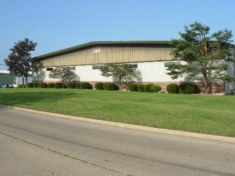
Property Record
555 Borden St, Woodstock, IL 60098

NEARBY LISTINGS FOR SALE OR LEASE
Property Detail
555 Borden St
Chicago-Naperville-Elgin, IL-IN-WI
Kilkenny Commons Unit 1
13-06-301-020
DOC 2014R0040172 N 75.15FT LT 3 KILKENNY COMMONS UNIT 1
Industrialgeneral
McHenry
X
Illinois
17111C0179J
3
2024
1.22 AC
2024
McHenry County
870903
Chicago
18,000 SF
DEMOGRAPHICS near 555 Borden St
1 Mile
3 Mile
5 Mile
2024 Total Population
5,014
24,523
30,649
2029 Population
5,013
24,488
30,667
Pop Growth 2024-2029
(0.02%)
(0.14%)
+ 0.06%
Average Age
41
40
41
2024 Total Households
1,895
9,340
11,624
HH Growth 2024-2029
0.00%
(0.17%)
+ 0.03%
Median Household Inc
$81,468
$74,831
$78,206
Avg Household Size
2.50
2.50
2.50
2024 Avg HH Vehicles
2.00
2.00
2.00
Median Home Value
$182,670
$199,371
$220,609
Median Year Built
1965
1979
1983
Nearby Places
Map Layers
Map Styles
 Street
 Aerial
- Restaurants
- Banks
- Shops
- Fitness
- Groceries
PUBLIC TRANSPORTATION
COMMUTER RAIL
Woodstock Station (Union Pacific Northwest Line - Northeast Illinois Regional Commuter Railroad (Metra))
DRIVE
WALK
Distance
Woodstock Station (Union Pacific Northwest Line - Northeast Illinois Regional Commuter Railroad (Metra))
5 min
2.0 mi
Freight Ports
Port Milwaukee
DRIVE
WALK
Distance
Port Milwaukee
98 min
69.8 mi
Nearby Properties
Address
Land Use
TOTAL SIZE
Lot Size
Zoning
Address
Land Use
TOTAL SIZE
Lot Size
Zoning
41,872 SF
19.37 AC
Address
Land Use
TOTAL SIZE
Lot Size
Zoning
58,535 SF
6.26 AC
Address
Land Use
TOTAL SIZE
Lot Size
Zoning
219,350 SF
19.83 AC
Address
Land Use
TOTAL SIZE
Lot Size
Zoning
129,755 SF
13.01 AC
Address
Land Use
TOTAL SIZE
Lot Size
Zoning
214,500 SF
21.21 AC
Address
Land Use
TOTAL SIZE
Lot Size
Zoning
64,528 SF
9.51 AC
Address
Land Use
TOTAL SIZE
Lot Size
Zoning
50,749 SF
5.92 AC
Address
Land Use
TOTAL SIZE
Lot Size
Zoning
96,633 SF
3.97 AC
Address
Land Use
TOTAL SIZE
Lot Size
Zoning
164,167 SF
16.11 AC
Address
Land Use
TOTAL SIZE
Lot Size
Zoning
581,330 SF
15.02 AC
Address
Land Use
TOTAL SIZE
Lot Size
Zoning
148,917 SF
9.22 AC
Address
Land Use
TOTAL SIZE
Lot Size
Zoning
72,582 SF
3.74 AC
Address
Land Use
TOTAL SIZE
Lot Size
Zoning
45,876 SF
5.02 AC
Address
Land Use
TOTAL SIZE
Lot Size
Zoning
93,884 SF
7.46 AC
Address
Land Use
TOTAL SIZE
Lot Size
Zoning
178,561 SF
19.09 AC
Address
Land Use
TOTAL SIZE
Lot Size
Zoning
12,699 SF
8 AC
Address
Land Use
TOTAL SIZE
Lot Size
Zoning
127,765 SF
7.91 AC
Address
Land Use
TOTAL SIZE
Lot Size
Zoning
71,740 SF
4.66 AC
Address
Land Use
TOTAL SIZE
Lot Size
Zoning
2.78 AC
Address
Land Use
TOTAL SIZE
Lot Size
Zoning
24,968 SF
0.50 AC
Address
Land Use
TOTAL SIZE
Lot Size
Zoning
93,280 SF
11.89 AC
Address
Land Use
TOTAL SIZE
Lot Size
Zoning
32,308 SF
4.58 AC
Address
Land Use
TOTAL SIZE
Lot Size
Zoning
130,669 SF
13.20 AC
Address
Land Use
TOTAL SIZE
Lot Size
Zoning
32,754 SF
0.11 AC
Address
Land Use
TOTAL SIZE
Lot Size
Zoning
53,200 SF
1.61 AC
Address
Land Use
TOTAL SIZE
Lot Size
Zoning
64,237 SF
5.73 AC
Address
Land Use
TOTAL SIZE
Lot Size
Zoning
Address
Land Use
TOTAL SIZE
Lot Size
Zoning
Address
Land Use
TOTAL SIZE
Lot Size
Zoning
16,376 SF
3.13 AC
Address
Land Use
TOTAL SIZE
Lot Size
Zoning
22,724 SF
3.63 AC
The World's #1 Commercial Real Estate Marketplace
Connect with us
© 2026 CoStar Group
The information above has been obtained from sources believed reliable. While we do not doubt its accuracy we have not verified it and make no guarantee, warranty or representation about it. It is your responsibility to independently confirm its accuracy and completeness. Any projections, opinions, assumptions, or estimates used are for example only and do not represent the current or future performance of the property. The value of this transaction to you depends on tax and other factors which should be evaluated by your tax, financial, and legal advisors. You and your advisors should conduct a careful, independent investigation of the property to determine to your satisfaction the suitability of the property for your needs.