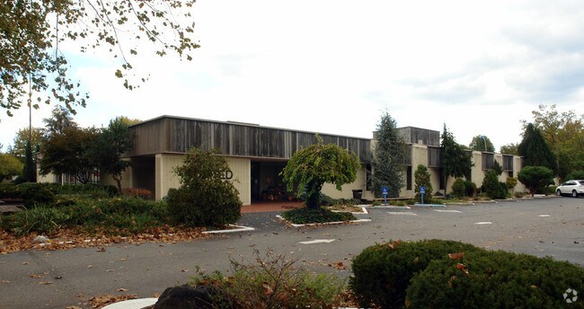
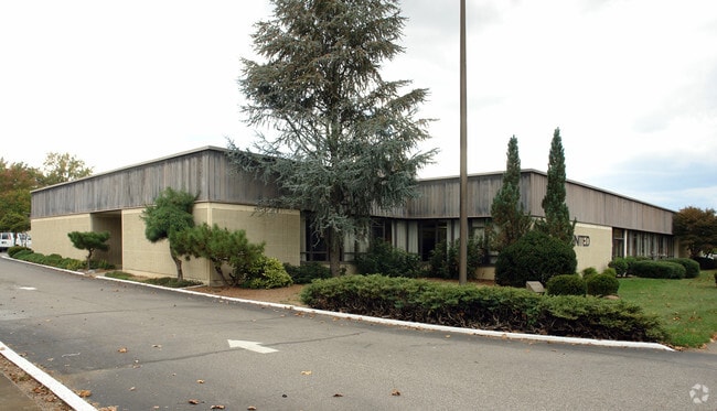
Property Record
555 C St, Ceredo, WV 25507
NEARBY LISTINGS FOR SALE OR LEASE
Property Detail
555 C St
03-6-02060001
60 X 180 FT HIGHLAND W 1ST ST (PAVING)
Financialbuilding
Wayne
X
West Virginia
54099C0020D
0.62 AC
2025
Wayne County
2025
Huntington/Ashland
020300
Huntington-Ashland, WV-KY-OH
DEMOGRAPHICS near 555 C St
1 Mile
3 Mile
5 Mile
2024 Total Population
2,622
18,580
36,534
2029 Population
2,482
18,014
35,665
Pop Growth 2024-2029
(5.34%)
(3.05%)
(2.38%)
Average Age
43
43
42
2024 Total Households
1,112
7,835
15,386
HH Growth 2024-2029
(5.31%)
(2.88%)
(2.25%)
Median Household Inc
$45,263
$48,882
$46,038
Avg Household Size
2.30
2.30
2.30
2024 Avg HH Vehicles
2.00
2.00
2.00
Median Home Value
$124,299
$120,988
$118,107
Median Year Built
1961
1969
1968
Nearby Places
Map Layers
Map Styles
 Street
 Aerial
- Restaurants
- Banks
- Shops
- Fitness
- Groceries
PUBLIC TRANSPORTATION
COMMUTER RAIL
DRIVE
WALK
Distance
16 min
7.3 mi
DRIVE
WALK
Distance
13 min
8.5 mi
AIRPORT
Tri-State/Milton J Ferguson Field
DRIVE
WALK
Distance
Tri-State/Milton J Ferguson Field
11 min
5.6 mi
Nearby Properties
Address
Land Use
TOTAL SIZE
Lot Size
Zoning
Address
Land Use
TOTAL SIZE
Lot Size
Zoning
492.60 AC
Address
Land Use
TOTAL SIZE
Lot Size
Zoning
0.69 AC
Z02
Address
Land Use
TOTAL SIZE
Lot Size
Zoning
Address
Land Use
TOTAL SIZE
Lot Size
Zoning
Address
Land Use
TOTAL SIZE
Lot Size
Zoning
2.83 AC
Address
Land Use
TOTAL SIZE
Lot Size
Zoning
348,219 SF
12 AC
Address
Land Use
TOTAL SIZE
Lot Size
Zoning
0.74 AC
Address
Land Use
TOTAL SIZE
Lot Size
Zoning
Address
Land Use
TOTAL SIZE
Lot Size
Zoning
Address
Land Use
TOTAL SIZE
Lot Size
Zoning
126,716 SF
10.60 AC
Address
Land Use
TOTAL SIZE
Lot Size
Zoning
33.45 AC
COMMERCIAL
Address
Land Use
TOTAL SIZE
Lot Size
Zoning
27,084 SF
3.73 AC
Address
Land Use
TOTAL SIZE
Lot Size
Zoning
68,160 SF
0.87 AC
Z01
Address
Land Use
TOTAL SIZE
Lot Size
Zoning
Address
Land Use
TOTAL SIZE
Lot Size
Zoning
Address
Land Use
TOTAL SIZE
Lot Size
Zoning
Address
Land Use
TOTAL SIZE
Lot Size
Zoning
Address
Land Use
TOTAL SIZE
Lot Size
Zoning
32,400 SF
3 AC
Address
Land Use
TOTAL SIZE
Lot Size
Zoning
132,113 SF
4.38 AC
Address
Land Use
TOTAL SIZE
Lot Size
Zoning
3.94 AC
COMMERCIAL
Address
Land Use
TOTAL SIZE
Lot Size
Zoning
0.87 AC
RESIDENTIA
Address
Land Use
TOTAL SIZE
Lot Size
Zoning
75,900 SF
6.04 AC
Address
Land Use
TOTAL SIZE
Lot Size
Zoning
0.27 AC
Z02
Address
Land Use
TOTAL SIZE
Lot Size
Zoning
19.68 AC
Address
Land Use
TOTAL SIZE
Lot Size
Zoning
2.78 AC
Z01
Address
Land Use
TOTAL SIZE
Lot Size
Zoning
60,000 SF
5 AC
Address
Land Use
TOTAL SIZE
Lot Size
Zoning
12.15 AC
Address
Land Use
TOTAL SIZE
Lot Size
Zoning
3.85 AC
OTHER
Address
Land Use
TOTAL SIZE
Lot Size
Zoning
2.20 AC
Address
Land Use
TOTAL SIZE
Lot Size
Zoning
0.10 AC
OTHER
The World's #1 Commercial Real Estate Marketplace
Connect with us
© 2025 CoStar Group
The information above has been obtained from sources believed reliable. While we do not doubt its accuracy we have not verified it and make no guarantee, warranty or representation about it. It is your responsibility to independently confirm its accuracy and completeness. Any projections, opinions, assumptions, or estimates used are for example only and do not represent the current or future performance of the property. The value of this transaction to you depends on tax and other factors which should be evaluated by your tax, financial, and legal advisors. You and your advisors should conduct a careful, independent investigation of the property to determine to your satisfaction the suitability of the property for your needs.