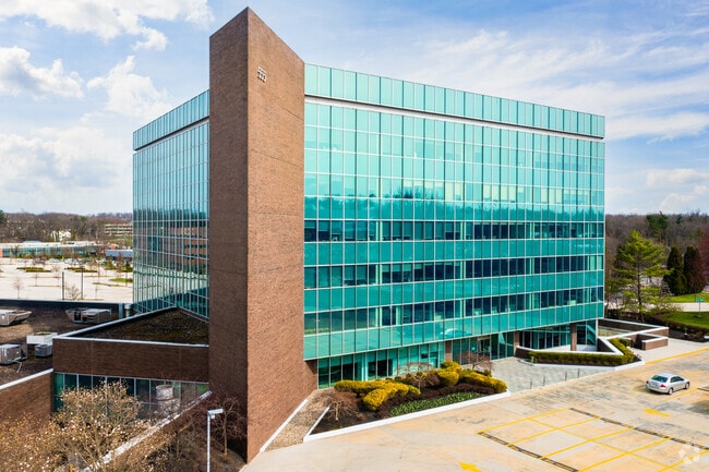
Property Record
130 N Radnor Chester Rd, Wayne, PA 19087
Current Lease Availabilities
NEARBY LISTINGS FOR SALE OR LEASE
Property Detail
130 N Radnor Chester Rd
36-02-01232-05
3 STY BLDG 21.885AC PARCEL 2
Officebuilding
Delaware
X
Pennsylvania
42029C0175G
21.89 AC
2024
Upper Main Line
2025
Philadelphia
409804
Philadelphia-Camden-Wilmington, PA-NJ-DE-MD
398,844 SF
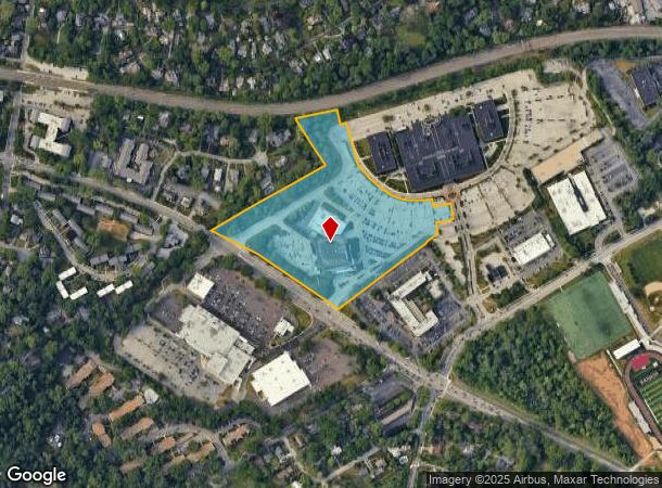
DEMOGRAPHICS near 130 N Radnor Chester Rd
1 mile
3 mile
5 mile
2024 Total Population
7,235
63,259
192,483
2029 Population
7,311
64,222
195,744
Pop Growth 2024-2029
+ 1.05%
+ 1.52%
+ 1.69%
Average Age
38
38
40
2024 Total Households
2,374
21,404
74,009
HH Growth 2024-2029
+ 1.26%
+ 1.71%
+ 1.97%
Median Household Inc
$178,826
$141,194
$124,406
Avg Household Size
2.50
2.50
2.40
2024 Avg HH Vehicles
2.00
2.00
2.00
Median Home Value
$859,499
$738,711
$553,171
Median Year Built
1962
1963
1963
Nearby Places
Map Layers
Map Styles
 Street
 Aerial
Transit
 Traffic
 Biking
Places
Listings with unknown addresses are not visible on the map
- Restaurants
- Banks
- Shops
- Fitness
- Groceries
PUBLIC TRANSPORTATION
TRANSIT/SUBWAY
St. Davids (R5 - Southeastern Pennsylvania Transportation Authority Regional Rail (SEPTA Regional Rail))
Drive
Walk
Distance
St. Davids (R5 - Southeastern Pennsylvania Transportation Authority Regional Rail (SEPTA Regional Rail))
2 min
9 min
0.5 mi
Radnor (R5 - Southeastern Pennsylvania Transportation Authority Regional Rail (SEPTA Regional Rail))
Drive
Walk
Distance
Radnor (R5 - Southeastern Pennsylvania Transportation Authority Regional Rail (SEPTA Regional Rail))
4 min
16 min
0.8 mi
COMMUTER RAIL
St. Davids (R5 - Southeastern Pennsylvania Transportation Authority Regional Rail (SEPTA Regional Rail))
Drive
Walk
Distance
St. Davids (R5 - Southeastern Pennsylvania Transportation Authority Regional Rail (SEPTA Regional Rail))
2 min
0.5 mi
Radnor (R5 - Southeastern Pennsylvania Transportation Authority Regional Rail (SEPTA Regional Rail))
Drive
Walk
Distance
Radnor (R5 - Southeastern Pennsylvania Transportation Authority Regional Rail (SEPTA Regional Rail))
4 min
16 min
0.8 mi
AIRPORT
Philadelphia International
Drive
Walk
Distance
Philadelphia International
32 min
19.8 mi
Trenton Mercer
Drive
Walk
Distance
Trenton Mercer
58 min
42.4 mi
Freight Ports
South Jersey Port
Drive
Walk
Distance
South Jersey Port
35 min
21.4 mi
Nearby Properties
Address
Land Use
TOTAL SIZE
Lot Size
Zoning
Address
Land Use
TOTAL SIZE
Lot Size
Zoning
703,572 SF
159 AC
Address
Land Use
TOTAL SIZE
Lot Size
Zoning
10.50 AC
Address
Land Use
TOTAL SIZE
Lot Size
Zoning
222,980 SF
57.68 AC
Address
Land Use
TOTAL SIZE
Lot Size
Zoning
48,900 SF
20 AC
Address
Land Use
TOTAL SIZE
Lot Size
Zoning
1,174,127 SF
2 AC
C1
Address
Land Use
TOTAL SIZE
Lot Size
Zoning
45,871 SF
112 AC
Address
Land Use
TOTAL SIZE
Lot Size
Zoning
1,037,806 SF
73.69 AC
R2
Address
Land Use
TOTAL SIZE
Lot Size
Zoning
350,807 SF
50 AC
R1
Address
Land Use
TOTAL SIZE
Lot Size
Zoning
254,781 SF
14.62 AC
Address
Land Use
TOTAL SIZE
Lot Size
Zoning
137,282 SF
14.33 AC
Address
Land Use
TOTAL SIZE
Lot Size
Zoning
73,193 SF
37.01 AC
Address
Land Use
TOTAL SIZE
Lot Size
Zoning
92,337 SF
7.30 AC
Address
Land Use
TOTAL SIZE
Lot Size
Zoning
872,232 SF
51.99 AC
G
Address
Land Use
TOTAL SIZE
Lot Size
Zoning
561,359 SF
48.06 AC
R1
Address
Land Use
TOTAL SIZE
Lot Size
Zoning
214,714 SF
22.23 AC
R1
Address
Land Use
TOTAL SIZE
Lot Size
Zoning
443,289 SF
41.78 AC
R2
Address
Land Use
TOTAL SIZE
Lot Size
Zoning
322,236 SF
50.80 AC
Address
Land Use
TOTAL SIZE
Lot Size
Zoning
30,787 SF
30.50 AC
Address
Land Use
TOTAL SIZE
Lot Size
Zoning
114,121 SF
16.80 AC
LI
Address
Land Use
TOTAL SIZE
Lot Size
Zoning
29,364 SF
21.90 AC
Address
Land Use
TOTAL SIZE
Lot Size
Zoning
193,290 SF
8.34 AC
Address
Land Use
TOTAL SIZE
Lot Size
Zoning
6,210 SF
17.16 AC
Address
Land Use
TOTAL SIZE
Lot Size
Zoning
33,000 SF
1 AC
Address
Land Use
TOTAL SIZE
Lot Size
Zoning
961,106 SF
5.47 AC
LI
Address
Land Use
TOTAL SIZE
Lot Size
Zoning
78,250 SF
34.50 AC
Address
Land Use
TOTAL SIZE
Lot Size
Zoning
799,754 SF
27.10 AC
R4
Address
Land Use
TOTAL SIZE
Lot Size
Zoning
4,350 SF
20 AC
Address
Land Use
TOTAL SIZE
Lot Size
Zoning
159,248 SF
23.13 AC
Address
Land Use
TOTAL SIZE
Lot Size
Zoning
342,407 SF
44 AC
The World's #1 Commercial Real Estate Marketplace
Connect with us
© 2026 CoStar Group
The information above has been obtained from sources believed reliable. While we do not doubt its accuracy we have not verified it and make no guarantee, warranty or representation about it. It is your responsibility to independently confirm its accuracy and completeness. Any projections, opinions, assumptions, or estimates used are for example only and do not represent the current or future performance of the property. The value of this transaction to you depends on tax and other factors which should be evaluated by your tax, financial, and legal advisors. You and your advisors should conduct a careful, independent investigation of the property to determine to your satisfaction the suitability of the property for your needs.