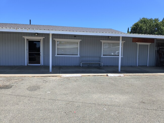
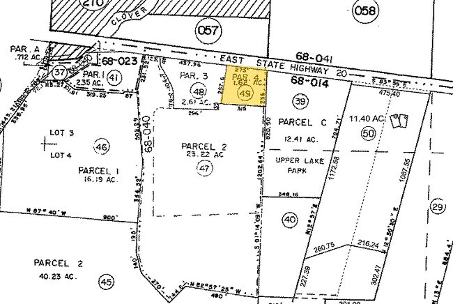
Property Record
555 E State Highway 20, Upper Lake, CA 95485

Current Lease Availabilities
Property Detail
555 E State Highway 20
004-010-490-000
Lake
Storebuilding
California
C3
1.78 AC
B and X Area of moderate flood hazard, usually the area between the limits of the 100-year and 500-year floods.
California North Rural Area
2025
Other Market Areas
2025
Clearlake, CA
000100
NEARBY LISTINGS FOR SALE OR LEASE
-
-
View all Upper Lake listings for lease on LoopNet.com
DEMOGRAPHICS near 555 E State Highway 20
1 mile
3 mile
5 mile
2025 Total Population
1,744
2,441
6,623
2030 Population
1,808
2,524
6,533
Pop Growth 2025-2030
+ 3.67%
+ 3.40%
(1.36%)
Average Age
39
40
44
2025 Total Households
645
923
2,723
HH Growth 2025-2030
+ 3.72%
+ 3.36%
(1.62%)
Median Household Inc
$79,167
$84,797
$65,346
Avg Household Size
2.60
2.50
2.40
2025 Avg HH Vehicles
2.00
2.00
2.00
Median Home Value
$369,897
$391,602
$378,928
Median Year Built
1984
1984
1982
Nearby Places
Map Layers
Map Styles
 Street
 Aerial
Transit
 Traffic
 Biking
Places
Listings with unknown addresses are not visible on the map
- Restaurants
- Banks
- Shops
- Fitness
- Groceries
Nearby Properties
Address
Land Use
TOTAL SIZE
Lot Size
Zoning
Address
Land Use
TOTAL SIZE
Lot Size
Zoning
5,768 SF
3.87 AC
CH
Address
Land Use
TOTAL SIZE
Lot Size
Zoning
25,470 SF
4.39 AC
C2
Address
Land Use
TOTAL SIZE
Lot Size
Zoning
3,220 SF
0.69 AC
C2
Address
Land Use
TOTAL SIZE
Lot Size
Zoning
11,088 SF
1.42 AC
CH
Address
Land Use
TOTAL SIZE
Lot Size
Zoning
36.63 AC
A
Address
Land Use
TOTAL SIZE
Lot Size
Zoning
1,200 SF
40.50 AC
A
Address
Land Use
TOTAL SIZE
Lot Size
Zoning
812 SF
0.32 AC
C2
Address
Land Use
TOTAL SIZE
Lot Size
Zoning
2,774 SF
62.48 AC
APZ
Address
Land Use
TOTAL SIZE
Lot Size
Zoning
Address
Land Use
TOTAL SIZE
Lot Size
Zoning
35.06 AC
A
Address
Land Use
TOTAL SIZE
Lot Size
Zoning
2,392 SF
20.74 AC
APZ
Address
Land Use
TOTAL SIZE
Lot Size
Zoning
4.89 AC
M2
Address
Land Use
TOTAL SIZE
Lot Size
Zoning
2,108 SF
16.13 AC
A
Address
Land Use
TOTAL SIZE
Lot Size
Zoning
1,344 SF
16.28 AC
A
Address
Land Use
TOTAL SIZE
Lot Size
Zoning
1,440 SF
105.62 AC
RL
Address
Land Use
TOTAL SIZE
Lot Size
Zoning
1,200 SF
245.50 AC
RL
Address
Land Use
TOTAL SIZE
Lot Size
Zoning
2,284 SF
8.97 AC
A
Address
Land Use
TOTAL SIZE
Lot Size
Zoning
2,340 SF
11.84 AC
A
Address
Land Use
TOTAL SIZE
Lot Size
Zoning
4,088 SF
2.63 AC
CH
Address
Land Use
TOTAL SIZE
Lot Size
Zoning
1,198 SF
11.96 AC
A
Address
Land Use
TOTAL SIZE
Lot Size
Zoning
960 SF
223.21 AC
RL
Address
Land Use
TOTAL SIZE
Lot Size
Zoning
1,160 SF
70.41 AC
A
Address
Land Use
TOTAL SIZE
Lot Size
Zoning
2,073 SF
6.23 AC
A
Address
Land Use
TOTAL SIZE
Lot Size
Zoning
2,146 SF
10.95 AC
A
Address
Land Use
TOTAL SIZE
Lot Size
Zoning
1,075 SF
8.15 AC
RL
Address
Land Use
TOTAL SIZE
Lot Size
Zoning
3,146 SF
18.35 AC
A
Address
Land Use
TOTAL SIZE
Lot Size
Zoning
1,640 SF
54.14 AC
RR
Address
Land Use
TOTAL SIZE
Lot Size
Zoning
2,244 SF
46 AC
A
Address
Land Use
TOTAL SIZE
Lot Size
Zoning
1,488 SF
78.28 AC
RL
Address
Land Use
TOTAL SIZE
Lot Size
Zoning
2,026 SF
20.07 AC
A
The World's #1 Commercial Real Estate Marketplace
Connect with us
© 2026 CoStar Group
The information above has been obtained from sources believed reliable. While we do not doubt its accuracy we have not verified it and make no guarantee, warranty or representation about it. It is your responsibility to independently confirm its accuracy and completeness. Any projections, opinions, assumptions, or estimates used are for example only and do not represent the current or future performance of the property. The value of this transaction to you depends on tax and other factors which should be evaluated by your tax, financial, and legal advisors. You and your advisors should conduct a careful, independent investigation of the property to determine to your satisfaction the suitability of the property for your needs.