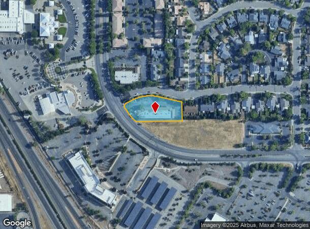
Property Record
555 Flying V St, Chico, CA 95928

NEARBY LISTINGS FOR SALE OR LEASE
Property Detail
555 Flying V St
Chico, CA
Charolais Estates Public Street S
002-550-020-000
LOT 1 CHAROLAIS ESTATES PUBLIC STREET SUB UNIT 1
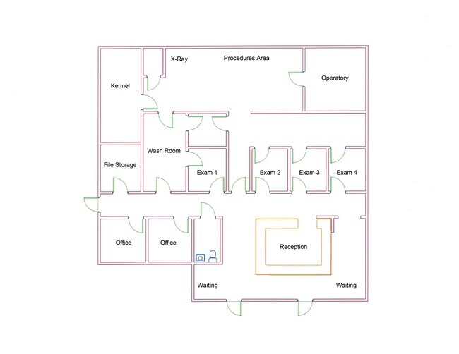
Storebuilding
Butte
X
California
06007C0506E
1
2024
0.97 AC
2025
Redding/Chico
000903
Other Market Areas
11,086 SF
DEMOGRAPHICS near 555 Flying V St
1 Mile
3 Mile
5 Mile
2024 Total Population
4,083
46,932
96,669
2029 Population
3,902
44,855
92,365
Pop Growth 2024-2029
(4.43%)
(4.43%)
(4.45%)
Average Age
37
37
37
2024 Total Households
1,610
19,517
39,793
HH Growth 2024-2029
(4.47%)
(4.63%)
(4.66%)
Median Household Inc
$61,200
$64,364
$66,757
Avg Household Size
2.40
2.30
2.30
2024 Avg HH Vehicles
2.00
2.00
2.00
Median Home Value
$387,055
$434,010
$417,915
Median Year Built
1986
1977
1980
Nearby Places
Map Layers
Map Styles
 Street
 Aerial
- Restaurants
- Banks
- Shops
- Fitness
- Groceries
PUBLIC TRANSPORTATION
COMMUTER RAIL
DRIVE
WALK
Distance
9 min
3.8 mi
SALE & LEASE HISTORY
LISTING DATE
SALE/LEASE

Sep 26, 2016
For Lease
Sep 25, 2016
For Lease
Feb 04, 2021
For Lease
Apr 02, 2024
For Lease
Nearby Properties
Address
Land Use
TOTAL SIZE
Lot Size
Zoning
Address
Land Use
TOTAL SIZE
Lot Size
Zoning
102,010 SF
12.55 AC
Address
Land Use
TOTAL SIZE
Lot Size
Zoning
58,013 SF
7.08 AC
TND
Address
Land Use
TOTAL SIZE
Lot Size
Zoning
13,186 SF
4.97 AC
R2
Address
Land Use
TOTAL SIZE
Lot Size
Zoning
32,880 SF
25.36 AC
Address
Land Use
TOTAL SIZE
Lot Size
Zoning
20,643 SF
3.32 AC
TND
Address
Land Use
TOTAL SIZE
Lot Size
Zoning
185,744 SF
10.15 AC
Address
Land Use
TOTAL SIZE
Lot Size
Zoning
84,280 SF
1.60 AC
R4
Address
Land Use
TOTAL SIZE
Lot Size
Zoning
21,216 SF
9.60 AC
CC
Address
Land Use
TOTAL SIZE
Lot Size
Zoning
104,992 SF
5.64 AC
CN
Address
Land Use
TOTAL SIZE
Lot Size
Zoning
133,120 SF
5.37 AC
R3
Address
Land Use
TOTAL SIZE
Lot Size
Zoning
141,333 SF
7.08 AC
Address
Land Use
TOTAL SIZE
Lot Size
Zoning
158,426 SF
16.19 AC
M1
Address
Land Use
TOTAL SIZE
Lot Size
Zoning
72,372 SF
1.90 AC
R3
Address
Land Use
TOTAL SIZE
Lot Size
Zoning
13,459 SF
3.61 AC
Address
Land Use
TOTAL SIZE
Lot Size
Zoning
160,214 SF
13.50 AC
Address
Land Use
TOTAL SIZE
Lot Size
Zoning
175,392 SF
14.83 AC
Address
Land Use
TOTAL SIZE
Lot Size
Zoning
31,291 SF
6.10 AC
CR
Address
Land Use
TOTAL SIZE
Lot Size
Zoning
44,492 SF
2.05 AC
R3
Address
Land Use
TOTAL SIZE
Lot Size
Zoning
18,809 SF
13.55 AC
Address
Land Use
TOTAL SIZE
Lot Size
Zoning
3.30 AC
CR
Address
Land Use
TOTAL SIZE
Lot Size
Zoning
51,698 SF
3.88 AC
C2
Address
Land Use
TOTAL SIZE
Lot Size
Zoning
99,180 SF
10.18 AC
OC
Address
Land Use
TOTAL SIZE
Lot Size
Zoning
24.26 AC
Address
Land Use
TOTAL SIZE
Lot Size
Zoning
90,400 SF
7.50 AC
Address
Land Use
TOTAL SIZE
Lot Size
Zoning
51,805 SF
2.50 AC
CN
Address
Land Use
TOTAL SIZE
Lot Size
Zoning
105,700 SF
10.03 AC
Address
Land Use
TOTAL SIZE
Lot Size
Zoning
22,032 SF
8.66 AC
Address
Land Use
TOTAL SIZE
Lot Size
Zoning
145,000 SF
4.93 AC
R3
Address
Land Use
TOTAL SIZE
Lot Size
Zoning
105,390 SF
8.13 AC
Address
Land Use
TOTAL SIZE
Lot Size
Zoning
74,180 SF
4.25 AC
00
The World's #1 Commercial Real Estate Marketplace
Connect with us
© 2026 CoStar Group
The information above has been obtained from sources believed reliable. While we do not doubt its accuracy we have not verified it and make no guarantee, warranty or representation about it. It is your responsibility to independently confirm its accuracy and completeness. Any projections, opinions, assumptions, or estimates used are for example only and do not represent the current or future performance of the property. The value of this transaction to you depends on tax and other factors which should be evaluated by your tax, financial, and legal advisors. You and your advisors should conduct a careful, independent investigation of the property to determine to your satisfaction the suitability of the property for your needs.