Property Record
555 Lacey Rd, Forked River, NJ 08731
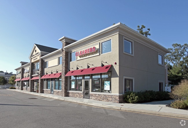


Property Detail
555 Lacey Rd
13-01465-0000-00015-01
IRR
Commercialnec
Ocean
OC
New Jersey
B and X Area of moderate flood hazard, usually the area between the limits of the 100-year and 500-year floods.
15.1
2025
0.74 AC
2025
Ocean County
732003
Northern New Jersey
7,200 SF
Lakewood-New Brunswick, NJ
NEARBY LISTINGS FOR SALE OR LEASE
DEMOGRAPHICS near 555 Lacey Rd
1 mile
3 mile
5 mile
2025 Total Population
8,072
31,040
53,790
2030 Population
8,196
31,822
55,242
Pop Growth 2025-2030
+ 1.54%
+ 2.52%
+ 2.70%
Average Age
40
41
41
2025 Total Households
2,898
11,540
19,985
HH Growth 2025-2030
+ 0.86%
+ 2.07%
+ 2.26%
Median Household Inc
$103,589
$101,437
$101,601
Avg Household Size
2.70
2.60
2.60
2025 Avg HH Vehicles
2.00
2.00
2.00
Median Home Value
$379,171
$395,298
$391,825
Median Year Built
1978
1981
1982
Nearby Places
Map Layers
Map Styles
 Street
 Aerial
Layers
 Traffic
 Biking
Places
Listings with unknown addresses are not visible on the map
- Restaurants
- Banks
- Shops
- Fitness
- Groceries
PUBLIC TRANSPORTATION
AIRPORT
Atlantic City International
Drive
Walk
Distance
Atlantic City International
73 min
42.0 mi
Freight Ports
South Jersey Port
Drive
Walk
Distance
South Jersey Port
80 min
59.6 mi
SALE & LEASE HISTORY
LISTING DATE
SALE/LEASE

Sep 25, 2016
For Lease
Jun 05, 2020
For Lease
Nearby Properties
Address
Land Use
TOTAL SIZE
Lot Size
Zoning
Address
Land Use
TOTAL SIZE
Lot Size
Zoning
139.60 AC
M6
Address
Land Use
TOTAL SIZE
Lot Size
Zoning
96.60 AC
R100
Address
Land Use
TOTAL SIZE
Lot Size
Zoning
2,000 SF
94 AC
CR
Address
Land Use
TOTAL SIZE
Lot Size
Zoning
528.70 AC
M6
Address
Land Use
TOTAL SIZE
Lot Size
Zoning
72.26 AC
R100
Address
Land Use
TOTAL SIZE
Lot Size
Zoning
1,807.87 AC
FA
Address
Land Use
TOTAL SIZE
Lot Size
Zoning
21.34 AC
C200
Address
Land Use
TOTAL SIZE
Lot Size
Zoning
10.49 AC
PURD
Address
Land Use
TOTAL SIZE
Lot Size
Zoning
9,617 SF
14.28 AC
WTB1
Address
Land Use
TOTAL SIZE
Lot Size
Zoning
142,047 SF
18.72 AC
C150
Address
Land Use
TOTAL SIZE
Lot Size
Zoning
9.88 AC
C150
Address
Land Use
TOTAL SIZE
Lot Size
Zoning
28.80 AC
R100
Address
Land Use
TOTAL SIZE
Lot Size
Zoning
960 SF
9.62 AC
R100
Address
Land Use
TOTAL SIZE
Lot Size
Zoning
19.28 AC
MLOF
Address
Land Use
TOTAL SIZE
Lot Size
Zoning
6.14 AC
C150
Address
Land Use
TOTAL SIZE
Lot Size
Zoning
9.45 AC
C200
Address
Land Use
TOTAL SIZE
Lot Size
Zoning
1,456 SF
9.65 AC
R-75
Address
Land Use
TOTAL SIZE
Lot Size
Zoning
47,440 SF
6.09 AC
R150
Address
Land Use
TOTAL SIZE
Lot Size
Zoning
8.44 AC
AH10
Address
Land Use
TOTAL SIZE
Lot Size
Zoning
8.76 AC
C150
Address
Land Use
TOTAL SIZE
Lot Size
Zoning
3,840 SF
244.21 AC
CR
Address
Land Use
TOTAL SIZE
Lot Size
Zoning
5.86 AC
AH10
Address
Land Use
TOTAL SIZE
Lot Size
Zoning
5 AC
C200
Address
Land Use
TOTAL SIZE
Lot Size
Zoning
7,200 SF
6.58 AC
CR/
Address
Land Use
TOTAL SIZE
Lot Size
Zoning
6.25 AC
C100
Address
Land Use
TOTAL SIZE
Lot Size
Zoning
6.21 AC
C150
Address
Land Use
TOTAL SIZE
Lot Size
Zoning
2,968 SF
14.08 AC
C150
Address
Land Use
TOTAL SIZE
Lot Size
Zoning
6,294 SF
4.13 AC
OC
Address
Land Use
TOTAL SIZE
Lot Size
Zoning
7.79 AC
C100
Address
Land Use
TOTAL SIZE
Lot Size
Zoning
6,976 SF
1.29 AC
C150
The World's #1 Commercial Real Estate Marketplace
Connect with us
© 2026 CoStar Group
The information above has been obtained from sources believed reliable. While we do not doubt its accuracy we have not verified it and make no guarantee, warranty or representation about it. It is your responsibility to independently confirm its accuracy and completeness. Any projections, opinions, assumptions, or estimates used are for example only and do not represent the current or future performance of the property. The value of this transaction to you depends on tax and other factors which should be evaluated by your tax, financial, and legal advisors. You and your advisors should conduct a careful, independent investigation of the property to determine to your satisfaction the suitability of the property for your needs.