Property Record
555 Main Rd, Johns Island, SC 29455
NEARBY LISTINGS FOR SALE OR LEASE
-
-
View all Johns Island listings for sale on LoopNet.com
Property Detail
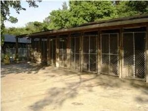
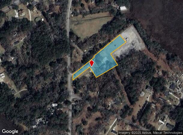
555 Main Rd
283-00-00-225
Pt Calif
Commercialnec
SUBDIVISION NAME -PT CALIF DESCRIPTION -TRACT B SITE NAME -K-9 KENNELS/PET CEMETERIES
X
Charleston
45019C0488K
South Carolina
2025
2.04 AC
2024
West Islands
002106
Charleston/N Charleston
900 SF
Charleston-North Charleston, SC
DEMOGRAPHICS near 555 Main Rd
1 Mile
3 Mile
5 Mile
2024 Total Population
1,010
14,936
58,752
2029 Population
1,086
15,963
62,748
Pop Growth 2024-2029
+ 7.52%
+ 6.88%
+ 6.80%
Average Age
43
40
40
2024 Total Households
411
6,160
25,315
HH Growth 2024-2029
+ 7.30%
+ 6.56%
+ 6.57%
Median Household Inc
$93,392
$88,881
$84,341
Avg Household Size
2.40
2.40
2.30
2024 Avg HH Vehicles
2.00
2.00
2.00
Median Home Value
$463,636
$375,172
$346,104
Median Year Built
2001
2008
2003
Nearby Places
Map Layers
Map Styles
 Street
 Aerial
- Restaurants
- Banks
- Shops
- Fitness
- Groceries
PUBLIC TRANSPORTATION
AIRPORT
Charleston AFB/International
DRIVE
WALK
Distance
Charleston AFB/International
26 min
17.3 mi
Freight Ports
Columbus Street Terminal
DRIVE
WALK
Distance
Columbus Street Terminal
23 min
12.8 mi
Nearby Properties
Address
Land Use
TOTAL SIZE
Lot Size
Zoning
Address
Land Use
TOTAL SIZE
Lot Size
Zoning
49,853 SF
15.75 AC
Address
Land Use
TOTAL SIZE
Lot Size
Zoning
55.08 AC
Address
Land Use
TOTAL SIZE
Lot Size
Zoning
34.54 AC
Address
Land Use
TOTAL SIZE
Lot Size
Zoning
16.01 AC
Address
Land Use
TOTAL SIZE
Lot Size
Zoning
5,421 SF
22.92 AC
Address
Land Use
TOTAL SIZE
Lot Size
Zoning
Address
Land Use
TOTAL SIZE
Lot Size
Zoning
13.30 AC
Address
Land Use
TOTAL SIZE
Lot Size
Zoning
4,500 SF
14.81 AC
Address
Land Use
TOTAL SIZE
Lot Size
Zoning
7,492 SF
9.54 AC
Address
Land Use
TOTAL SIZE
Lot Size
Zoning
5,632 SF
16.98 AC
Address
Land Use
TOTAL SIZE
Lot Size
Zoning
400 SF
19.83 AC
Address
Land Use
TOTAL SIZE
Lot Size
Zoning
22,578 SF
23.54 AC
Address
Land Use
TOTAL SIZE
Lot Size
Zoning
14.07 AC
Address
Land Use
TOTAL SIZE
Lot Size
Zoning
1,800 SF
0.83 AC
Address
Land Use
TOTAL SIZE
Lot Size
Zoning
3.40 AC
Address
Land Use
TOTAL SIZE
Lot Size
Zoning
1,342 SF
7.76 AC
Address
Land Use
TOTAL SIZE
Lot Size
Zoning
1.91 AC
Address
Land Use
TOTAL SIZE
Lot Size
Zoning
3,270 SF
5.50 AC
Address
Land Use
TOTAL SIZE
Lot Size
Zoning
69.97 AC
Address
Land Use
TOTAL SIZE
Lot Size
Zoning
10,500 SF
5.78 AC
Address
Land Use
TOTAL SIZE
Lot Size
Zoning
5,392 SF
2 AC
Address
Land Use
TOTAL SIZE
Lot Size
Zoning
8.41 AC
Address
Land Use
TOTAL SIZE
Lot Size
Zoning
39,520 SF
9.62 AC
Address
Land Use
TOTAL SIZE
Lot Size
Zoning
42,409 SF
5.76 AC
Address
Land Use
TOTAL SIZE
Lot Size
Zoning
34.93 AC
Address
Land Use
TOTAL SIZE
Lot Size
Zoning
Address
Land Use
TOTAL SIZE
Lot Size
Zoning
13.71 AC
Address
Land Use
TOTAL SIZE
Lot Size
Zoning
14,472 SF
1.90 AC
Address
Land Use
TOTAL SIZE
Lot Size
Zoning
Address
Land Use
TOTAL SIZE
Lot Size
Zoning
52.13 AC
The World's #1 Commercial Real Estate Marketplace
Connect with us
© 2025 CoStar Group
The information above has been obtained from sources believed reliable. While we do not doubt its accuracy we have not verified it and make no guarantee, warranty or representation about it. It is your responsibility to independently confirm its accuracy and completeness. Any projections, opinions, assumptions, or estimates used are for example only and do not represent the current or future performance of the property. The value of this transaction to you depends on tax and other factors which should be evaluated by your tax, financial, and legal advisors. You and your advisors should conduct a careful, independent investigation of the property to determine to your satisfaction the suitability of the property for your needs.