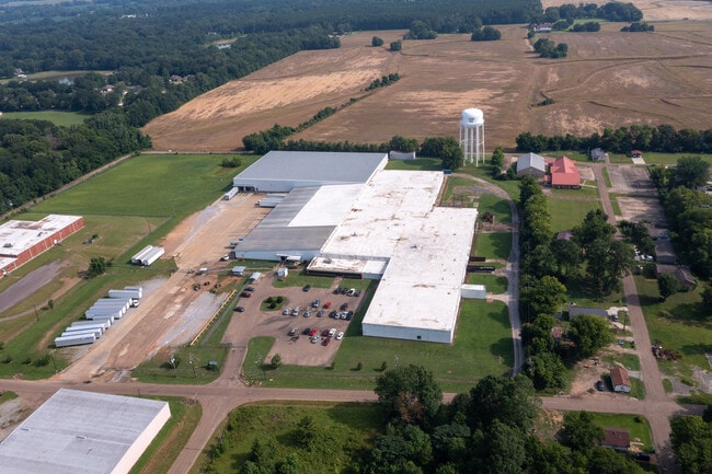
Property Record
555 Matthews Dr, Canton, MS 39046
Current Lease Availabilities
Property Detail
555 Matthews Dr
Jackson, MS
LOT A INDUSTRIAL PK SUBD
093D-18D-178-00-00
Madison
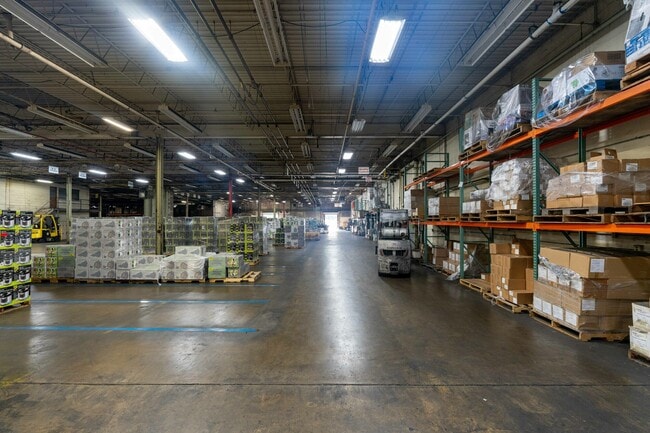
Warehouse
Mississippi
B and X Area of moderate flood hazard, usually the area between the limits of the 100-year and 500-year floods.
a
2025
15 AC
2025
Outlying Madison County
031100
Jackson
69,000 SF
NEARBY LISTINGS FOR SALE OR LEASE
DEMOGRAPHICS near 555 Matthews Dr
1 mile
3 mile
5 mile
2025 Total Population
3,584
14,744
18,088
2030 Population
3,844
15,658
19,190
Pop Growth 2025-2030
+ 7.25%
+ 6.20%
+ 6.09%
Average Age
37
37
37
2025 Total Households
1,209
5,342
6,702
HH Growth 2025-2030
+ 7.78%
+ 6.50%
+ 6.39%
Median Household Inc
$29,963
$29,619
$35,470
Avg Household Size
2.70
2.60
2.60
2025 Avg HH Vehicles
2.00
2.00
2.00
Median Home Value
$123,513
$130,386
$163,316
Median Year Built
1974
1976
1982
Nearby Places
Map Layers
Map Styles
 Street
 Aerial
Layers
 Traffic
 Biking
Places
Listings with unknown addresses are not visible on the map
- Restaurants
- Banks
- Shops
- Fitness
- Groceries
PUBLIC TRANSPORTATION
AIRPORT
Jackson-Medgar Wiley Evers International
Drive
Walk
Distance
Jackson-Medgar Wiley Evers International
49 min
33.9 mi
Nearby Properties
Address
Land Use
TOTAL SIZE
Lot Size
Zoning
Address
Land Use
TOTAL SIZE
Lot Size
Zoning
56,033 SF
6.90 AC
SU1
Address
Land Use
TOTAL SIZE
Lot Size
Zoning
73,843 SF
3.90 AC
I1
Address
Land Use
TOTAL SIZE
Lot Size
Zoning
56,033 SF
1 AC
Address
Land Use
TOTAL SIZE
Lot Size
Zoning
41,462 SF
2 AC
Address
Land Use
TOTAL SIZE
Lot Size
Zoning
1,697 SF
9.25 AC
R3
Address
Land Use
TOTAL SIZE
Lot Size
Zoning
59.86 AC
Address
Land Use
TOTAL SIZE
Lot Size
Zoning
1,027 SF
7.40 AC
R3
Address
Land Use
TOTAL SIZE
Lot Size
Zoning
4,139 SF
12 AC
Address
Land Use
TOTAL SIZE
Lot Size
Zoning
62,594 SF
9.80 AC
Address
Land Use
TOTAL SIZE
Lot Size
Zoning
2,854 SF
7.90 AC
R3
Address
Land Use
TOTAL SIZE
Lot Size
Zoning
59,180 SF
2.85 AC
Address
Land Use
TOTAL SIZE
Lot Size
Zoning
1,752 SF
Address
Land Use
TOTAL SIZE
Lot Size
Zoning
29,489 SF
4.30 AC
Address
Land Use
TOTAL SIZE
Lot Size
Zoning
1,380 SF
22.40 AC
R5
Address
Land Use
TOTAL SIZE
Lot Size
Zoning
2,454 SF
7.30 AC
R3
Address
Land Use
TOTAL SIZE
Lot Size
Zoning
23,217 SF
4.64 AC
Address
Land Use
TOTAL SIZE
Lot Size
Zoning
4,155 SF
4.90 AC
PUD
Address
Land Use
TOTAL SIZE
Lot Size
Zoning
26,382 SF
1.84 AC
Address
Land Use
TOTAL SIZE
Lot Size
Zoning
21,319 SF
3.78 AC
Address
Land Use
TOTAL SIZE
Lot Size
Zoning
3,850 SF
2.10 AC
Address
Land Use
TOTAL SIZE
Lot Size
Zoning
6,147 SF
2.55 AC
Address
Land Use
TOTAL SIZE
Lot Size
Zoning
38,363 SF
7.90 AC
Address
Land Use
TOTAL SIZE
Lot Size
Zoning
19,311 SF
0.82 AC
Address
Land Use
TOTAL SIZE
Lot Size
Zoning
4,934 SF
9.70 AC
R3
Address
Land Use
TOTAL SIZE
Lot Size
Zoning
3,514 SF
4.80 AC
R3
Address
Land Use
TOTAL SIZE
Lot Size
Zoning
6,256 SF
3 AC
R2
Address
Land Use
TOTAL SIZE
Lot Size
Zoning
7,416 SF
2.60 AC
Address
Land Use
TOTAL SIZE
Lot Size
Zoning
6,501 SF
2.83 AC
R3
Address
Land Use
TOTAL SIZE
Lot Size
Zoning
3,525 SF
2.71 AC
The World's #1 Commercial Real Estate Marketplace
Connect with us
© 2026 CoStar Group
The information above has been obtained from sources believed reliable. While we do not doubt its accuracy we have not verified it and make no guarantee, warranty or representation about it. It is your responsibility to independently confirm its accuracy and completeness. Any projections, opinions, assumptions, or estimates used are for example only and do not represent the current or future performance of the property. The value of this transaction to you depends on tax and other factors which should be evaluated by your tax, financial, and legal advisors. You and your advisors should conduct a careful, independent investigation of the property to determine to your satisfaction the suitability of the property for your needs.