Property Record
555 Paper Mill Rd, Newark, DE 19711

Property Detail
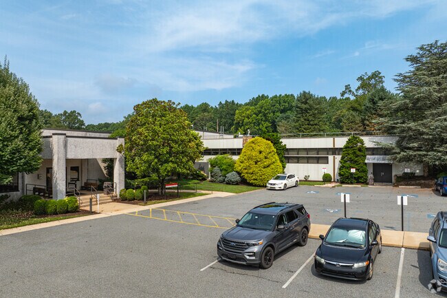
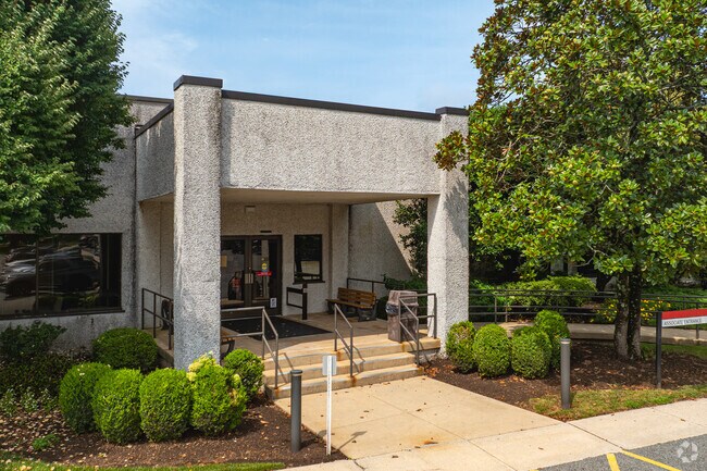
555 Paper Mill Rd
Officebuilding
NEW CASTLE
OR
Delaware
AE The base floodplain where base flood elevations are provided. AE Zones are now used on new format FIRMs instead of A1-A30 Zones.
154.32 AC
2025
New Castle County
2025
Philadelphia
013610
Philadelphia-Camden-Wilmington, PA-NJ-DE-MD
21,243 SF
08-046.00-002
NEARBY LISTINGS FOR SALE OR LEASE
DEMOGRAPHICS near 555 Paper Mill Rd
1 mile
3 mile
5 mile
2025 Total Population
2,753
62,133
138,606
2030 Population
2,760
65,588
143,596
Pop Growth 2025-2030
+ 0.25%
+ 5.56%
+ 3.60%
Average Age
43
36
39
2025 Total Households
1,100
21,964
52,479
HH Growth 2025-2030
0.00%
+ 5.89%
+ 3.71%
Median Household Inc
$113,333
$82,922
$89,629
Avg Household Size
2.40
2.40
2.40
2025 Avg HH Vehicles
2.00
2.00
2.00
Median Home Value
$492,999
$376,060
$363,265
Median Year Built
1981
1979
1979
Nearby Places
Map Layers
Map Styles
 Street
 Aerial
Transit
 Traffic
 Biking
Places
Listings with unknown addresses are not visible on the map
- Restaurants
- Banks
- Shops
- Fitness
- Groceries
PUBLIC TRANSPORTATION
COMMUTER RAIL
Newark (R2 - Southeastern Pennsylvania Transportation Authority Regional Rail (SEPTA Regional Rail))
Drive
Walk
Distance
Newark (R2 - Southeastern Pennsylvania Transportation Authority Regional Rail (SEPTA Regional Rail))
7 min
3.4 mi
Churchmans Crossing (R2 - Southeastern Pennsylvania Transportation Authority Regional Rail (SEPTA Regional Rail))
Drive
Walk
Distance
Churchmans Crossing (R2 - Southeastern Pennsylvania Transportation Authority Regional Rail (SEPTA Regional Rail))
13 min
6.3 mi
AIRPORT
Philadelphia International
Drive
Walk
Distance
Philadelphia International
51 min
36.0 mi
Freight Ports
Port of Wilmington, RI
Drive
Walk
Distance
Port of Wilmington, RI
26 min
15.9 mi
Nearby Properties
Address
Land Use
TOTAL SIZE
Lot Size
Zoning
Address
Land Use
TOTAL SIZE
Lot Size
Zoning
354.61 AC
18UN
Address
Land Use
TOTAL SIZE
Lot Size
Zoning
108,170 SF
111.08 AC
18UN
Address
Land Use
TOTAL SIZE
Lot Size
Zoning
169,544 SF
60.86 AC
OR
Address
Land Use
TOTAL SIZE
Lot Size
Zoning
43,943 SF
8.95 AC
18BB
Address
Land Use
TOTAL SIZE
Lot Size
Zoning
80,834 SF
4.60 AC
18BB
Address
Land Use
TOTAL SIZE
Lot Size
Zoning
92,081 SF
30.99 AC
18RM
Address
Land Use
TOTAL SIZE
Lot Size
Zoning
Address
Land Use
TOTAL SIZE
Lot Size
Zoning
54,907 SF
21.74 AC
18RA
Address
Land Use
TOTAL SIZE
Lot Size
Zoning
2,960 SF
346.49 AC
SR
Address
Land Use
TOTAL SIZE
Lot Size
Zoning
193.62 AC
SR
Address
Land Use
TOTAL SIZE
Lot Size
Zoning
57,214 SF
1.10 AC
18BB
Address
Land Use
TOTAL SIZE
Lot Size
Zoning
119,820 SF
19.86 AC
18UN
Address
Land Use
TOTAL SIZE
Lot Size
Zoning
332,800 SF
18.70 AC
NCAP
Address
Land Use
TOTAL SIZE
Lot Size
Zoning
102,955 SF
9.57 AC
I
Address
Land Use
TOTAL SIZE
Lot Size
Zoning
108,553 SF
5.89 AC
18RM
Address
Land Use
TOTAL SIZE
Lot Size
Zoning
225,947 SF
18.68 AC
NCAP
Address
Land Use
TOTAL SIZE
Lot Size
Zoning
Address
Land Use
TOTAL SIZE
Lot Size
Zoning
396,768 SF
11.96 AC
NCAP
Address
Land Use
TOTAL SIZE
Lot Size
Zoning
11.79 AC
18UN
Address
Land Use
TOTAL SIZE
Lot Size
Zoning
576 SF
112.26 AC
18PL
Address
Land Use
TOTAL SIZE
Lot Size
Zoning
320,016 SF
10.15 AC
NCAP
Address
Land Use
TOTAL SIZE
Lot Size
Zoning
7,146 SF
20 AC
S
Address
Land Use
TOTAL SIZE
Lot Size
Zoning
6,016 SF
20.65 AC
18MI
Address
Land Use
TOTAL SIZE
Lot Size
Zoning
104,800 SF
1.22 AC
18UN
Address
Land Use
TOTAL SIZE
Lot Size
Zoning
10,512 SF
119.43 AC
18RS
Address
Land Use
TOTAL SIZE
Lot Size
Zoning
95.67 AC
SR
Address
Land Use
TOTAL SIZE
Lot Size
Zoning
72,725 SF
18.48 AC
18OFD
Address
Land Use
TOTAL SIZE
Lot Size
Zoning
94.65 AC
SR
Address
Land Use
TOTAL SIZE
Lot Size
Zoning
120,623 SF
9.57 AC
18RA
The World's #1 Commercial Real Estate Marketplace
Connect with us
© 2026 CoStar Group
The information above has been obtained from sources believed reliable. While we do not doubt its accuracy we have not verified it and make no guarantee, warranty or representation about it. It is your responsibility to independently confirm its accuracy and completeness. Any projections, opinions, assumptions, or estimates used are for example only and do not represent the current or future performance of the property. The value of this transaction to you depends on tax and other factors which should be evaluated by your tax, financial, and legal advisors. You and your advisors should conduct a careful, independent investigation of the property to determine to your satisfaction the suitability of the property for your needs.