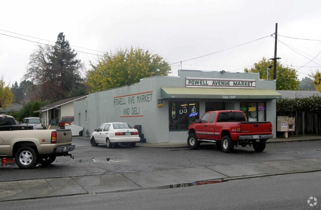
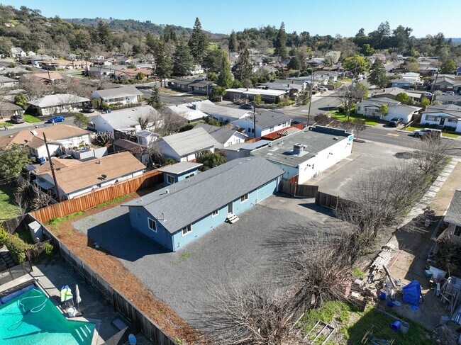
Property Record
555 Powell Ave, Healdsburg, CA 95448


Property Detail
555 Powell Ave
002-383-010
2013 FM PTN 002-383-009 LOT 1 PM 175 751M02
Storemultistory
Sonoma
COML
California
B and X Area of moderate flood hazard, usually the area between the limits of the 100-year and 500-year floods.
1
2025
0.24 AC
2025
Healdsburg/Cloverdale
153903
North Bay/Santa Rosa
1,920 SF
Santa Rosa-Petaluma, CA
NEARBY LISTINGS FOR SALE OR LEASE
DEMOGRAPHICS near 555 Powell Ave
1 mile
3 mile
5 mile
2025 Total Population
10,172
14,884
19,540
2030 Population
10,372
15,126
19,729
Pop Growth 2025-2030
+ 1.97%
+ 1.63%
+ 0.97%
Average Age
45
46
45
2025 Total Households
4,122
6,006
7,593
HH Growth 2025-2030
+ 1.89%
+ 1.52%
+ 0.92%
Median Household Inc
$103,699
$103,237
$110,067
Avg Household Size
2.40
2.40
2.50
2025 Avg HH Vehicles
2.00
2.00
2.00
Median Home Value
$916,666
$951,683
$927,506
Median Year Built
1977
1979
1981
Nearby Places
Map Layers
Map Styles
 Street
 Aerial
Layers
 Traffic
 Biking
Places
Listings with unknown addresses are not visible on the map
- Restaurants
- Banks
- Shops
- Fitness
- Groceries
PUBLIC TRANSPORTATION
AIRPORT
Charles M Schulz - Sonoma County
Drive
Walk
Distance
Charles M Schulz - Sonoma County
18 min
11.4 mi
Freight Ports
Port of Richmond
Drive
Walk
Distance
Port of Richmond
82 min
64.3 mi
SALE & LEASE HISTORY
LISTING DATE
SALE/LEASE

Oct 08, 2024
For Sale
Nearby Properties
Address
Land Use
TOTAL SIZE
Lot Size
Zoning
Address
Land Use
TOTAL SIZE
Lot Size
Zoning
87.32 AC
Address
Land Use
TOTAL SIZE
Lot Size
Zoning
82,639 SF
1.87 AC
Address
Land Use
TOTAL SIZE
Lot Size
Zoning
10.26 AC
CITYHE
Address
Land Use
TOTAL SIZE
Lot Size
Zoning
0.15 AC
DA10
Address
Land Use
TOTAL SIZE
Lot Size
Zoning
7.25 AC
Address
Land Use
TOTAL SIZE
Lot Size
Zoning
1,091 SF
362.51 AC
Address
Land Use
TOTAL SIZE
Lot Size
Zoning
57,500 SF
1.67 AC
Address
Land Use
TOTAL SIZE
Lot Size
Zoning
19,893 SF
48.66 AC
Address
Land Use
TOTAL SIZE
Lot Size
Zoning
10,800 SF
9.42 AC
Address
Land Use
TOTAL SIZE
Lot Size
Zoning
32,540 SF
0.51 AC
CITYHE
Address
Land Use
TOTAL SIZE
Lot Size
Zoning
16.07 AC
Address
Land Use
TOTAL SIZE
Lot Size
Zoning
2,800 SF
3.39 AC
CITYHE
Address
Land Use
TOTAL SIZE
Lot Size
Zoning
50,373 SF
5.98 AC
Address
Land Use
TOTAL SIZE
Lot Size
Zoning
25,439 SF
0.58 AC
Address
Land Use
TOTAL SIZE
Lot Size
Zoning
7,024 SF
6.47 AC
Address
Land Use
TOTAL SIZE
Lot Size
Zoning
9,133 SF
7.92 AC
Address
Land Use
TOTAL SIZE
Lot Size
Zoning
6,234 SF
10.35 AC
Address
Land Use
TOTAL SIZE
Lot Size
Zoning
1,888 SF
268.03 AC
LIA20
Address
Land Use
TOTAL SIZE
Lot Size
Zoning
47,971 SF
0.18 AC
Address
Land Use
TOTAL SIZE
Lot Size
Zoning
2,096 SF
410.90 AC
RRDW100
Address
Land Use
TOTAL SIZE
Lot Size
Zoning
41,048 SF
2 AC
Address
Land Use
TOTAL SIZE
Lot Size
Zoning
4,031 SF
13.35 AC
Address
Land Use
TOTAL SIZE
Lot Size
Zoning
8,884 SF
38.28 AC
Address
Land Use
TOTAL SIZE
Lot Size
Zoning
44,697 SF
3.85 AC
Address
Land Use
TOTAL SIZE
Lot Size
Zoning
973 SF
111.66 AC
Address
Land Use
TOTAL SIZE
Lot Size
Zoning
1,160 SF
3.02 AC
CITYHE
Address
Land Use
TOTAL SIZE
Lot Size
Zoning
8,518 SF
1.36 AC
RRB8FRZN
Address
Land Use
TOTAL SIZE
Lot Size
Zoning
10,801 SF
0.14 AC
CITYHE
Address
Land Use
TOTAL SIZE
Lot Size
Zoning
5,520 SF
9.19 AC
LIA20
Address
Land Use
TOTAL SIZE
Lot Size
Zoning
36,428 SF
2.67 AC
The World's #1 Commercial Real Estate Marketplace
Connect with us
© 2026 CoStar Group
The information above has been obtained from sources believed reliable. While we do not doubt its accuracy we have not verified it and make no guarantee, warranty or representation about it. It is your responsibility to independently confirm its accuracy and completeness. Any projections, opinions, assumptions, or estimates used are for example only and do not represent the current or future performance of the property. The value of this transaction to you depends on tax and other factors which should be evaluated by your tax, financial, and legal advisors. You and your advisors should conduct a careful, independent investigation of the property to determine to your satisfaction the suitability of the property for your needs.