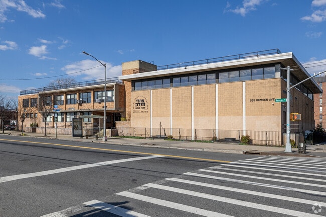
Property Record
555 Remsen Ave, Brooklyn, NY 11236

Save to a Folder
{{folder.Name}}
{{folder.ListingIds.length}} Properties
{{folder.ListingIds.length}} Property
Create a New Folder
Property Detail
555 Remsen Ave
04687-0001
DOCID-2018100100032007ADDL BLK-LOT: 5733-44
Publichealthcarefacility
Kings
C8-1
New York
B and X Area of moderate flood hazard, usually the area between the limits of the 100-year and 500-year floods.
1
0
0.78 AC
2026
South Brooklyn
088800
Long Island (New York)
28,220 SF
New York-Jersey City-White Plains, NY-NJ
NEARBY LISTINGS FOR SALE OR LEASE
DEMOGRAPHICS near 555 Remsen Ave
1 mile
3 mile
5 mile
2025 Total Population
119,130
1,061,136
2,438,311
2030 Population
115,778
1,044,983
2,400,629
Pop Growth 2025-2030
(2.81%)
(1.52%)
(1.55%)
Average Age
41
40
39
2025 Total Households
41,212
384,777
874,130
HH Growth 2025-2030
(3.35%)
(1.83%)
(1.75%)
Median Household Inc
$56,385
$71,482
$79,594
Avg Household Size
2.70
2.60
2.60
2025 Avg HH Vehicles
1.00
1.00
1.00
Median Home Value
$692,266
$803,419
$862,536
Median Year Built
1948
1948
1948
Nearby Places
Map Layers
Map Styles
 Street
 Aerial
Layers
 Traffic
 Biking
Places
Listings with unknown addresses are not visible on the map
- Restaurants
- Banks
- Shops
- Fitness
- Groceries
PUBLIC TRANSPORTATION
TRANSIT/SUBWAY
Saratoga Avenue (3 - New York MTA Subway (The Subway), 4 - New York MTA Subway (The Subway))
Drive
Walk
Distance
Saratoga Avenue (3 - New York MTA Subway (The Subway), 4 - New York MTA Subway (The Subway))
2 min
16 min
0.8 mi
Sutter Avenue-Rutland Road (3 - New York MTA Subway (The Subway), 4 - New York MTA Subway (The Subway))
Drive
Walk
Distance
Sutter Avenue-Rutland Road (3 - New York MTA Subway (The Subway), 4 - New York MTA Subway (The Subway))
3 min
18 min
0.9 mi
COMMUTER RAIL
East New York Station (Far Rockaway Branch - Long Island Rail Road, Long Beach Branch - Long Island Rail Road, West Hempstead Branch - Long Island Rail Road)
Drive
Walk
Distance
East New York Station (Far Rockaway Branch - Long Island Rail Road, Long Beach Branch - Long Island Rail Road, West Hempstead Branch - Long Island Rail Road)
4 min
2.3 mi
Nostrand Avenue Station (Far Rockaway Branch - Long Island Rail Road, Hempstead Branch - Long Island Rail Road, Long Beach Branch - Long Island Rail Road, West Hempstead Branch - Long Island Rail Road)
Drive
Walk
Distance
Nostrand Avenue Station (Far Rockaway Branch - Long Island Rail Road, Hempstead Branch - Long Island Rail Road, Long Beach Branch - Long Island Rail Road, West Hempstead Branch - Long Island Rail Road)
9 min
3.3 mi
AIRPORT
John F Kennedy International
Drive
Walk
Distance
John F Kennedy International
15 min
9.4 mi
LaGuardia
Drive
Walk
Distance
LaGuardia
24 min
10.6 mi
Newark Liberty International
Drive
Walk
Distance
Newark Liberty International
37 min
21.0 mi
Freight Ports
NY - Red Hook Container Terminal
Drive
Walk
Distance
NY - Red Hook Container Terminal
13 min
6.4 mi
SALE & LEASE HISTORY
LISTING DATE
SALE/LEASE

Nov 16, 2020
For Sale
Nearby Properties
Address
Land Use
TOTAL SIZE
Lot Size
Zoning
Address
Land Use
TOTAL SIZE
Lot Size
Zoning
1,281,577 SF
20.78 AC
M3-1
Address
Land Use
TOTAL SIZE
Lot Size
Zoning
1,503,150 SF
20.47 AC
R5
Address
Land Use
TOTAL SIZE
Lot Size
Zoning
393.54 AC
PARK
Address
Land Use
TOTAL SIZE
Lot Size
Zoning
1,061,228 SF
8.86 AC
R5
Address
Land Use
TOTAL SIZE
Lot Size
Zoning
1,073,920 SF
16.53 AC
R6
Address
Land Use
TOTAL SIZE
Lot Size
Zoning
5,302 SF
366.15 AC
PARK
Address
Land Use
TOTAL SIZE
Lot Size
Zoning
561,945 SF
11.58 AC
R6
Address
Land Use
TOTAL SIZE
Lot Size
Zoning
1,688,760 SF
24.65 AC
R5
Address
Land Use
TOTAL SIZE
Lot Size
Zoning
296,915 SF
0.31 AC
C5-3
Address
Land Use
TOTAL SIZE
Lot Size
Zoning
785,450 SF
14.22 AC
R6
Address
Land Use
TOTAL SIZE
Lot Size
Zoning
61.60 AC
PARK
Address
Land Use
TOTAL SIZE
Lot Size
Zoning
566,000 SF
12.33 AC
R6
Address
Land Use
TOTAL SIZE
Lot Size
Zoning
473,345 SF
1.27 AC
R8X
Address
Land Use
TOTAL SIZE
Lot Size
Zoning
1,526,800 SF
32.39 AC
R5
Address
Land Use
TOTAL SIZE
Lot Size
Zoning
600 SF
33.07 AC
PARK
Address
Land Use
TOTAL SIZE
Lot Size
Zoning
1,493,793 SF
14.19 AC
R5
Address
Land Use
TOTAL SIZE
Lot Size
Zoning
6,000 SF
110.42 AC
PARK
Address
Land Use
TOTAL SIZE
Lot Size
Zoning
1,420,000 SF
19.61 AC
R5
Address
Land Use
TOTAL SIZE
Lot Size
Zoning
1,485,000 SF
20.28 AC
R5
Address
Land Use
TOTAL SIZE
Lot Size
Zoning
511,776 SF
2.33 AC
R6
Address
Land Use
TOTAL SIZE
Lot Size
Zoning
363,548 SF
1.81 AC
Address
Land Use
TOTAL SIZE
Lot Size
Zoning
393,092 SF
1.07 AC
R8A
Address
Land Use
TOTAL SIZE
Lot Size
Zoning
462,052 SF
1.08 AC
C63A
Address
Land Use
TOTAL SIZE
Lot Size
Zoning
333,424 SF
1.78 AC
C45D
Address
Land Use
TOTAL SIZE
Lot Size
Zoning
24,400 SF
33.98 AC
C4-2
Address
Land Use
TOTAL SIZE
Lot Size
Zoning
229,456 SF
4.15 AC
M1-1
Address
Land Use
TOTAL SIZE
Lot Size
Zoning
308,757 SF
0.74 AC
R7-1
Address
Land Use
TOTAL SIZE
Lot Size
Zoning
28.64 AC
PARK
Address
Land Use
TOTAL SIZE
Lot Size
Zoning
635,994 SF
17.90 AC
R5
Address
Land Use
TOTAL SIZE
Lot Size
Zoning
241,735 SF
1.99 AC
C8-4
The World's #1 Commercial Real Estate Marketplace
Connect with us
© 2026 CoStar Group
The information above has been obtained from sources believed reliable. While we do not doubt its accuracy we have not verified it and make no guarantee, warranty or representation about it. It is your responsibility to independently confirm its accuracy and completeness. Any projections, opinions, assumptions, or estimates used are for example only and do not represent the current or future performance of the property. The value of this transaction to you depends on tax and other factors which should be evaluated by your tax, financial, and legal advisors. You and your advisors should conduct a careful, independent investigation of the property to determine to your satisfaction the suitability of the property for your needs.