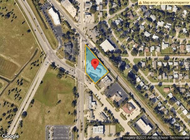
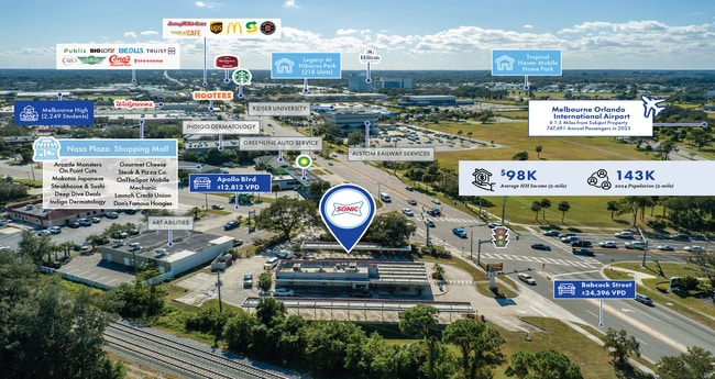
Property Record
555 S Babcock St, Melbourne, FL 32901
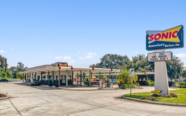
This Property Is For Sale
NEARBY LISTINGS FOR SALE OR LEASE
Property Detail
555 S Babcock St
Palm Bay-Melbourne-Titusville, FL
Indian River Bluff No 2
27-37-34-00-00284.0-0000.00
PART OF NW 1/4 OF NW 1/4 E OF APOLLO BLVD & W OF FEC RR AS DESC IN ORB 1695 PG 53 & LOT 269 & ADJ 15 FT ON S EXC RD R/W AS DESC IN ORB 683 PG 829 PAR 51-*-269 SEC 27
Restaurantdrivein
Brevard
X
Florida
12009C0601H
26
2024
1.26 AC
2025
Brevard County
064702
Orlando
1,582 SF
DEMOGRAPHICS near 555 S Babcock St
1 Mile
3 Mile
5 Mile
2024 Total Population
4,226
46,913
144,435
2029 Population
4,654
51,402
158,244
Pop Growth 2024-2029
+ 10.13%
+ 9.57%
+ 9.56%
Average Age
47
44
44
2024 Total Households
1,806
20,023
63,556
HH Growth 2024-2029
+ 10.41%
+ 9.48%
+ 9.40%
Median Household Inc
$49,174
$50,963
$61,317
Avg Household Size
2.00
2.10
2.20
2024 Avg HH Vehicles
2.00
2.00
2.00
Median Home Value
$167,965
$238,540
$265,392
Median Year Built
1978
1976
1983
Nearby Places
- Restaurants
- Banks
- Shops
- Fitness
- Groceries
PUBLIC TRANSPORTATION
AIRPORT
Melbourne Orlando International
DRIVE
WALK
Distance
Melbourne Orlando International
8 min
2.3 mi
Freight Ports
Port Canaveral
DRIVE
WALK
Distance
Port Canaveral
48 min
25.8 mi
Nearby Properties
Address
Land Use
TOTAL SIZE
Lot Size
Zoning
Address
Land Use
TOTAL SIZE
Lot Size
Zoning
1,105,462 SF
18.74 AC
CC1
Address
Land Use
TOTAL SIZE
Lot Size
Zoning
1,245,196 SF
110.73 AC
I1
Address
Land Use
TOTAL SIZE
Lot Size
Zoning
475,791 SF
229.02 AC
M1
Address
Land Use
TOTAL SIZE
Lot Size
Zoning
265,062 SF
14.75 AC
M1
Address
Land Use
TOTAL SIZE
Lot Size
Zoning
332,802 SF
37.02 AC
I1
Address
Land Use
TOTAL SIZE
Lot Size
Zoning
672 SF
57.80 AC
I1
Address
Land Use
TOTAL SIZE
Lot Size
Zoning
387,843 SF
27.19 AC
R3
Address
Land Use
TOTAL SIZE
Lot Size
Zoning
197,734 SF
27.99 AC
M1
Address
Land Use
TOTAL SIZE
Lot Size
Zoning
213,482 SF
1.27 AC
Address
Land Use
TOTAL SIZE
Lot Size
Zoning
280,518 SF
13.88 AC
Address
Land Use
TOTAL SIZE
Lot Size
Zoning
328,357 SF
34.11 AC
I1
Address
Land Use
TOTAL SIZE
Lot Size
Zoning
24.95 AC
I1
Address
Land Use
TOTAL SIZE
Lot Size
Zoning
295,347 SF
14.61 AC
R2
Address
Land Use
TOTAL SIZE
Lot Size
Zoning
213,704 SF
0.57 AC
CC3
Address
Land Use
TOTAL SIZE
Lot Size
Zoning
542,262 SF
51.88 AC
CP
Address
Land Use
TOTAL SIZE
Lot Size
Zoning
201,325 SF
11.41 AC
Address
Land Use
TOTAL SIZE
Lot Size
Zoning
207,405 SF
28.05 AC
R26
Address
Land Use
TOTAL SIZE
Lot Size
Zoning
226,121 SF
17.73 AC
Address
Land Use
TOTAL SIZE
Lot Size
Zoning
225,020 SF
24.25 AC
Address
Land Use
TOTAL SIZE
Lot Size
Zoning
74,716 SF
366.45 AC
M1
Address
Land Use
TOTAL SIZE
Lot Size
Zoning
364,027 SF
22.91 AC
C2
Address
Land Use
TOTAL SIZE
Lot Size
Zoning
182,494 SF
8.53 AC
CCP
Address
Land Use
TOTAL SIZE
Lot Size
Zoning
219,361 SF
3.63 AC
CC3
Address
Land Use
TOTAL SIZE
Lot Size
Zoning
139,968 SF
23.46 AC
CRA
Address
Land Use
TOTAL SIZE
Lot Size
Zoning
205,564 SF
14.56 AC
M1
Address
Land Use
TOTAL SIZE
Lot Size
Zoning
159,590 SF
26.66 AC
R26
Address
Land Use
TOTAL SIZE
Lot Size
Zoning
206,724 SF
11.74 AC
R3 (15)
Address
Land Use
TOTAL SIZE
Lot Size
Zoning
340,577 SF
29.82 AC
CP
Address
Land Use
TOTAL SIZE
Lot Size
Zoning
248,019 SF
12.22 AC
P1
Address
Land Use
TOTAL SIZE
Lot Size
Zoning
672 SF
261.50 AC
M1
The World's #1 Commercial Real Estate Marketplace
Connect with us
© 2025 CoStar Group
The information above has been obtained from sources believed reliable. While we do not doubt its accuracy we have not verified it and make no guarantee, warranty or representation about it. It is your responsibility to independently confirm its accuracy and completeness. Any projections, opinions, assumptions, or estimates used are for example only and do not represent the current or future performance of the property. The value of this transaction to you depends on tax and other factors which should be evaluated by your tax, financial, and legal advisors. You and your advisors should conduct a careful, independent investigation of the property to determine to your satisfaction the suitability of the property for your needs.