Property Record
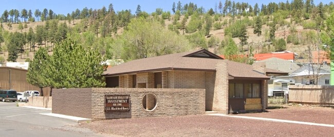
555 S Blackbird Roost, Flagstaff, AZ 86001

Property Detail
555 S Blackbird Roost
103-01-007B
SUBDIVISION: RIORDAN ADD SIXTEENTH: NW QUARTER: NW SECTION: 21 TOWNSHIP: 21N RANGE: 07E PCL IN NW4 DESC AS FLLWS: BEG INTERSECTION S ROW CLAY AVE & W ROW BLACKBIRD ROOST; TH S 02-00-38 E 133.63 TO TPOB; TH N 88-52-45 W 389.38; TH S 47-57-05 W 91.80;
Warehouse
COCONINO
AE The base floodplain where base flood elevations are provided. AE Zones are now used on new format FIRMs instead of A1-A30 Zones.
Arizona
2024
2.08 AC
2025
Flagstaff
001103
Other Market Areas
20,128 SF
Flagstaff, AZ
NEARBY LISTINGS FOR SALE OR LEASE
DEMOGRAPHICS near 555 S Blackbird Roost
1 mile
3 mile
5 mile
2024 Total Population
16,752
55,341
72,563
2029 Population
16,626
55,002
72,220
Pop Growth 2024-2029
(0.75%)
(0.61%)
(0.47%)
Average Age
26
32
33
2024 Total Households
3,879
17,980
24,281
HH Growth 2024-2029
(2.32%)
(1.59%)
(1.36%)
Median Household Inc
$40,422
$59,837
$66,981
Avg Household Size
2.20
2.40
2.40
2024 Avg HH Vehicles
2.00
2.00
2.00
Median Home Value
$338,144
$468,660
$473,783
Median Year Built
1991
1994
1992
Nearby Places
Map Layers
Map Styles
 Street
 Aerial
Transit
 Traffic
 Biking
Places
Listings with unknown addresses are not visible on the map
- Restaurants
- Banks
- Shops
- Fitness
- Groceries
PUBLIC TRANSPORTATION
COMMUTER RAIL
Drive
Walk
Distance
3 min
18 min
0.9 mi
AIRPORT
Flagstaff Pulliam
Drive
Walk
Distance
Flagstaff Pulliam
11 min
5.4 mi
SALE & LEASE HISTORY
LISTING DATE
SALE/LEASE

Apr 29, 2025
For Lease
Nearby Properties
Address
Land Use
TOTAL SIZE
Lot Size
Zoning
Address
Land Use
TOTAL SIZE
Lot Size
Zoning
385,095 SF
13.33 AC
Address
Land Use
TOTAL SIZE
Lot Size
Zoning
579,936 SF
6.07 AC
Address
Land Use
TOTAL SIZE
Lot Size
Zoning
602,053 SF
4.81 AC
Address
Land Use
TOTAL SIZE
Lot Size
Zoning
475,521 SF
12.26 AC
Address
Land Use
TOTAL SIZE
Lot Size
Zoning
544,788 SF
93.65 AC
Address
Land Use
TOTAL SIZE
Lot Size
Zoning
323,846 SF
26.50 AC
Address
Land Use
TOTAL SIZE
Lot Size
Zoning
366,782 SF
2.01 AC
Address
Land Use
TOTAL SIZE
Lot Size
Zoning
308,364 SF
2.43 AC
Address
Land Use
TOTAL SIZE
Lot Size
Zoning
239,308 SF
16.28 AC
Address
Land Use
TOTAL SIZE
Lot Size
Zoning
233,703 SF
14.92 AC
Address
Land Use
TOTAL SIZE
Lot Size
Zoning
178,737 SF
7.35 AC
Address
Land Use
TOTAL SIZE
Lot Size
Zoning
182,018 SF
11.28 AC
Address
Land Use
TOTAL SIZE
Lot Size
Zoning
218,329 SF
39.12 AC
Address
Land Use
TOTAL SIZE
Lot Size
Zoning
202,220 SF
4.31 AC
Address
Land Use
TOTAL SIZE
Lot Size
Zoning
144,737 SF
15.01 AC
Address
Land Use
TOTAL SIZE
Lot Size
Zoning
176,750 SF
9.53 AC
Address
Land Use
TOTAL SIZE
Lot Size
Zoning
125,784 SF
298.81 AC
Address
Land Use
TOTAL SIZE
Lot Size
Zoning
161,548 SF
6.71 AC
Address
Land Use
TOTAL SIZE
Lot Size
Zoning
124,394 SF
3.84 AC
Address
Land Use
TOTAL SIZE
Lot Size
Zoning
19.92 AC
Address
Land Use
TOTAL SIZE
Lot Size
Zoning
41,141 SF
0.92 AC
Address
Land Use
TOTAL SIZE
Lot Size
Zoning
75,751 SF
4.76 AC
Address
Land Use
TOTAL SIZE
Lot Size
Zoning
91,531 SF
6.75 AC
Address
Land Use
TOTAL SIZE
Lot Size
Zoning
109,623 SF
15.24 AC
Address
Land Use
TOTAL SIZE
Lot Size
Zoning
181,848 SF
21.01 AC
Address
Land Use
TOTAL SIZE
Lot Size
Zoning
51,619 SF
4.33 AC
Address
Land Use
TOTAL SIZE
Lot Size
Zoning
116,631 SF
5.60 AC
Address
Land Use
TOTAL SIZE
Lot Size
Zoning
110,642 SF
12.40 AC
Address
Land Use
TOTAL SIZE
Lot Size
Zoning
122,164 SF
10.74 AC
Address
Land Use
TOTAL SIZE
Lot Size
Zoning
50,798 SF
5 AC
The World's #1 Commercial Real Estate Marketplace
Connect with us
© 2026 CoStar Group
The information above has been obtained from sources believed reliable. While we do not doubt its accuracy we have not verified it and make no guarantee, warranty or representation about it. It is your responsibility to independently confirm its accuracy and completeness. Any projections, opinions, assumptions, or estimates used are for example only and do not represent the current or future performance of the property. The value of this transaction to you depends on tax and other factors which should be evaluated by your tax, financial, and legal advisors. You and your advisors should conduct a careful, independent investigation of the property to determine to your satisfaction the suitability of the property for your needs.