Property Record
555 Taylor Rd, Enfield, CT 06082
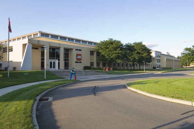

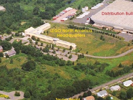
Property Detail
555 Taylor Rd
ENFI-000099-000000-000011
Capitol
Industrialgeneral
Connecticut
I-1
11
C and X Area of minimal flood hazard, usually depicted on FIRMs as above the 500-year flood level.
23.48 AC
2025
Enfield
2025
Hartford
480900
Hartford-West Hartford-East Hartford, CT
90,776 SF
NEARBY LISTINGS FOR SALE OR LEASE
DEMOGRAPHICS near 555 Taylor Rd
1 mile
3 mile
5 mile
2025 Total Population
1,293
23,499
77,942
2030 Population
1,321
24,006
79,064
Pop Growth 2025-2030
+ 2.17%
+ 2.16%
+ 1.44%
Average Age
43
44
43
2025 Total Households
405
8,890
30,132
HH Growth 2025-2030
+ 2.22%
+ 2.29%
+ 1.49%
Median Household Inc
$128,963
$102,809
$100,485
Avg Household Size
2.40
2.40
2.40
2025 Avg HH Vehicles
2.00
2.00
2.00
Median Home Value
$243,292
$290,044
$320,253
Median Year Built
1958
1966
1962
Nearby Places
Map Layers
Map Styles
 Street
 Aerial
Transit
 Traffic
 Biking
Places
Listings with unknown addresses are not visible on the map
- Restaurants
- Banks
- Shops
- Fitness
- Groceries
PUBLIC TRANSPORTATION
AIRPORT
Bradley International
Drive
Walk
Distance
Bradley International
30 min
13.7 mi
Freight Ports
Port of New Haven
Drive
Walk
Distance
Port of New Haven
81 min
60.6 mi
SALE & LEASE HISTORY
LISTING DATE
SALE/LEASE

Jun 17, 2020
For Sale
Nearby Properties
Address
Land Use
TOTAL SIZE
Lot Size
Zoning
Address
Land Use
TOTAL SIZE
Lot Size
Zoning
750,000 SF
405 AC
A-1
Address
Land Use
TOTAL SIZE
Lot Size
Zoning
69.62 AC
MFHD
Address
Land Use
TOTAL SIZE
Lot Size
Zoning
226,545 SF
14 AC
A-1
Address
Land Use
TOTAL SIZE
Lot Size
Zoning
370.78 AC
R88
Address
Land Use
TOTAL SIZE
Lot Size
Zoning
283.30 AC
R88
Address
Land Use
TOTAL SIZE
Lot Size
Zoning
166,268 SF
36.70 AC
R44
Address
Land Use
TOTAL SIZE
Lot Size
Zoning
142,872 SF
57.41 AC
INDG
Address
Land Use
TOTAL SIZE
Lot Size
Zoning
500,000 SF
71.20 AC
I-1
Address
Land Use
TOTAL SIZE
Lot Size
Zoning
121.07 AC
I-1
Address
Land Use
TOTAL SIZE
Lot Size
Zoning
49.16 AC
I-1
Address
Land Use
TOTAL SIZE
Lot Size
Zoning
36.97 AC
I-1
Address
Land Use
TOTAL SIZE
Lot Size
Zoning
211,256 SF
41.58 AC
R33
Address
Land Use
TOTAL SIZE
Lot Size
Zoning
121 AC
A-1
Address
Land Use
TOTAL SIZE
Lot Size
Zoning
57,328 SF
11.15 AC
INDG
Address
Land Use
TOTAL SIZE
Lot Size
Zoning
1.87 AC
BP
Address
Land Use
TOTAL SIZE
Lot Size
Zoning
259,093 SF
27.01 AC
INDG
Address
Land Use
TOTAL SIZE
Lot Size
Zoning
17.34 AC
R44
Address
Land Use
TOTAL SIZE
Lot Size
Zoning
54.05 AC
I-1
Address
Land Use
TOTAL SIZE
Lot Size
Zoning
111,890 SF
22.08 AC
INDG
Address
Land Use
TOTAL SIZE
Lot Size
Zoning
172,241 SF
11.21 AC
INDG
Address
Land Use
TOTAL SIZE
Lot Size
Zoning
15.91 AC
R44
Address
Land Use
TOTAL SIZE
Lot Size
Zoning
104,111 SF
11.16 AC
I-1
Address
Land Use
TOTAL SIZE
Lot Size
Zoning
55,096 SF
18.80 AC
R44
Address
Land Use
TOTAL SIZE
Lot Size
Zoning
212,178 SF
13.90 AC
INDG
Address
Land Use
TOTAL SIZE
Lot Size
Zoning
70,659 SF
19.62 AC
R44
Address
Land Use
TOTAL SIZE
Lot Size
Zoning
53,850 SF
8.12 AC
R33
Address
Land Use
TOTAL SIZE
Lot Size
Zoning
58,382 SF
15.91 AC
R33
Address
Land Use
TOTAL SIZE
Lot Size
Zoning
17,426 SF
1.78 AC
B
Address
Land Use
TOTAL SIZE
Lot Size
Zoning
169,680 SF
11.49 AC
I-1
The World's #1 Commercial Real Estate Marketplace
Connect with us
© 2026 CoStar Group
The information above has been obtained from sources believed reliable. While we do not doubt its accuracy we have not verified it and make no guarantee, warranty or representation about it. It is your responsibility to independently confirm its accuracy and completeness. Any projections, opinions, assumptions, or estimates used are for example only and do not represent the current or future performance of the property. The value of this transaction to you depends on tax and other factors which should be evaluated by your tax, financial, and legal advisors. You and your advisors should conduct a careful, independent investigation of the property to determine to your satisfaction the suitability of the property for your needs.