Property Record
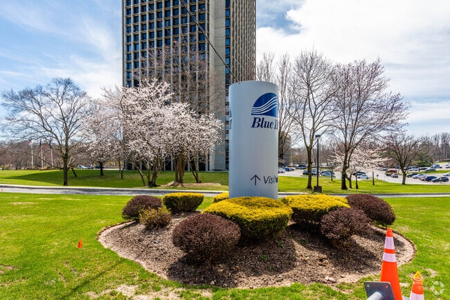
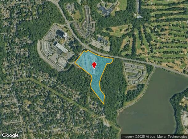
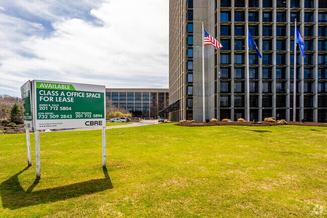
555 Veterans Memorial Dr W, Pearl River, NY 10965
NEARBY LISTINGS FOR SALE OR LEASE
Property Detail
555 Veterans Memorial Dr W
New York-Jersey City-White Plains, NY-NJ
Blue Hill Plaza Inc Sub
392489-073-010-0001-005-000-0000
20/24/335/3
Apartment
Rockland
X
New York
34003C0092H
5.0
2023
25.87 AC
2024
Orangetown
012700
Northern New Jersey
180,223 SF
DEMOGRAPHICS near 555 Veterans Memorial Dr W
1 Mile
3 Mile
5 Mile
2024 Total Population
8,696
65,865
188,587
2029 Population
8,682
65,830
188,295
Pop Growth 2024-2029
(0.16%)
(0.05%)
(0.15%)
Average Age
42
42
41
2024 Total Households
3,072
22,653
64,058
HH Growth 2024-2029
(0.33%)
(0.04%)
(0.17%)
Median Household Inc
$150,552
$146,224
$128,836
Avg Household Size
2.80
2.80
2.80
2024 Avg HH Vehicles
2.00
2.00
2.00
Median Home Value
$665,490
$674,952
$659,601
Median Year Built
1961
1964
1965
Nearby Places
- Restaurants
- Banks
- Shops
- Fitness
- Groceries
PUBLIC TRANSPORTATION
COMMUTER RAIL
Pearl River (Pascack Valley Line - NJ Transit Commuter Rail (NJ Transit))
DRIVE
WALK
Distance
Pearl River (Pascack Valley Line - NJ Transit Commuter Rail (NJ Transit))
7 min
2.2 mi
Montvale (Pascack Valley Line - NJ Transit Commuter Rail (NJ Transit))
DRIVE
WALK
Distance
Montvale (Pascack Valley Line - NJ Transit Commuter Rail (NJ Transit))
8 min
2.8 mi
AIRPORT
Westchester County
DRIVE
WALK
Distance
Westchester County
41 min
26.3 mi
LaGuardia
DRIVE
WALK
Distance
LaGuardia
49 min
29.0 mi
Newark Liberty International
DRIVE
WALK
Distance
Newark Liberty International
46 min
32.2 mi
Freight Ports
NY - Red Hook Container Terminal
DRIVE
WALK
Distance
NY - Red Hook Container Terminal
59 min
33.4 mi
SALE & LEASE HISTORY
LISTING DATE
SALE/LEASE

Sep 24, 2016
For Lease
Nearby Properties
Address
Land Use
TOTAL SIZE
Lot Size
Zoning
Address
Land Use
TOTAL SIZE
Lot Size
Zoning
63,621 SF
180.20 AC
LI
Address
Land Use
TOTAL SIZE
Lot Size
Zoning
Address
Land Use
TOTAL SIZE
Lot Size
Zoning
11.48 AC
OR-3
Address
Land Use
TOTAL SIZE
Lot Size
Zoning
237,408 SF
14.97 AC
R-40
Address
Land Use
TOTAL SIZE
Lot Size
Zoning
845.02 AC
Address
Land Use
TOTAL SIZE
Lot Size
Zoning
191,950 SF
43.03 AC
RA25
Address
Land Use
TOTAL SIZE
Lot Size
Zoning
24.45 AC
R40
Address
Land Use
TOTAL SIZE
Lot Size
Zoning
62,728 SF
14.49 AC
RA15
Address
Land Use
TOTAL SIZE
Lot Size
Zoning
1,295,615 SF
93.54 AC
OP
Address
Land Use
TOTAL SIZE
Lot Size
Zoning
144,751 SF
22.87 AC
RA
Address
Land Use
TOTAL SIZE
Lot Size
Zoning
231,978 SF
48.30 AC
R-40
Address
Land Use
TOTAL SIZE
Lot Size
Zoning
440 SF
98.43 AC
EO
Address
Land Use
TOTAL SIZE
Lot Size
Zoning
8.02 AC
BUS2
Address
Land Use
TOTAL SIZE
Lot Size
Zoning
11.45 AC
A
Address
Land Use
TOTAL SIZE
Lot Size
Zoning
114,520 SF
6.71 AC
R4
Address
Land Use
TOTAL SIZE
Lot Size
Zoning
41,552 SF
115.62 AC
A-1
Address
Land Use
TOTAL SIZE
Lot Size
Zoning
132,614 SF
15.74 AC
OR3
Address
Land Use
TOTAL SIZE
Lot Size
Zoning
60,798 SF
22.08 AC
A
Address
Land Use
TOTAL SIZE
Lot Size
Zoning
107,043 SF
11 AC
OR3
Address
Land Use
TOTAL SIZE
Lot Size
Zoning
Address
Land Use
TOTAL SIZE
Lot Size
Zoning
119,025 SF
16.57 AC
OR3
Address
Land Use
TOTAL SIZE
Lot Size
Zoning
13 AC
R40
Address
Land Use
TOTAL SIZE
Lot Size
Zoning
1,872 SF
48.93 AC
RA40
Address
Land Use
TOTAL SIZE
Lot Size
Zoning
54,347 SF
3.88 AC
B1
Address
Land Use
TOTAL SIZE
Lot Size
Zoning
8.50 AC
R20
Address
Land Use
TOTAL SIZE
Lot Size
Zoning
10.66 AC
R15
Address
Land Use
TOTAL SIZE
Lot Size
Zoning
9.29 AC
OR3
Address
Land Use
TOTAL SIZE
Lot Size
Zoning
33.50 AC
Address
Land Use
TOTAL SIZE
Lot Size
Zoning
78,600 SF
3.06 AC
SC
Address
Land Use
TOTAL SIZE
Lot Size
Zoning
6,810 SF
120.70 AC
R-40
The World's #1 Commercial Real Estate Marketplace
Connect with us
© 2025 CoStar Group
The information above has been obtained from sources believed reliable. While we do not doubt its accuracy we have not verified it and make no guarantee, warranty or representation about it. It is your responsibility to independently confirm its accuracy and completeness. Any projections, opinions, assumptions, or estimates used are for example only and do not represent the current or future performance of the property. The value of this transaction to you depends on tax and other factors which should be evaluated by your tax, financial, and legal advisors. You and your advisors should conduct a careful, independent investigation of the property to determine to your satisfaction the suitability of the property for your needs.