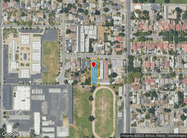
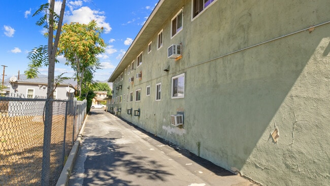
Property Record
555 W 25Th St, San Bernardino, CA 92405
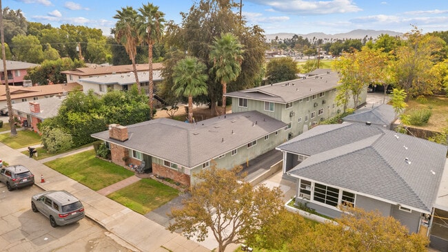

This Property Is For Sale
NEARBY LISTINGS FOR SALE OR LEASE
Property Detail
555 W 25Th St
Riverside-San Bernardino-Ontario, CA
Rancho San Bernardino
0149-175-06
R S B W 75 FT E 355 FT S 270 FT N 1050.36 FT LOT 1 BLK 84
Multifamilydwelling
San Bernardino
X
California
06071C7945H
1
2024
0.47 AC
2025
Arrowview
005300
Inland Empire (California)
6,533 SF
DEMOGRAPHICS near 555 W 25Th St
1 Mile
3 Mile
5 Mile
2024 Total Population
27,869
168,654
328,970
2029 Population
28,305
171,183
333,643
Pop Growth 2024-2029
+ 1.56%
+ 1.50%
+ 1.42%
Average Age
34
34
34
2024 Total Households
7,879
47,701
91,015
HH Growth 2024-2029
+ 1.54%
+ 1.58%
+ 1.48%
Median Household Inc
$53,748
$54,271
$59,410
Avg Household Size
3.40
3.40
3.50
2024 Avg HH Vehicles
2.00
2.00
2.00
Median Home Value
$318,506
$325,274
$341,995
Median Year Built
1952
1962
1967
Nearby Places
Map Layers
Map Styles
 Street
 Aerial
- Restaurants
- Banks
- Shops
- Fitness
- Groceries
PUBLIC TRANSPORTATION
COMMUTER RAIL
DRIVE
WALK
Distance
8 min
3.0 mi
San Bernardino (Inland Empire-Orange County Line - Southern California Regional Rail Authority (Metrolink), San Bernardino Line - Southern California Regional Rail Authority (Metrolink))
DRIVE
WALK
Distance
San Bernardino (Inland Empire-Orange County Line - Southern California Regional Rail Authority (Metrolink), San Bernardino Line - Southern California Regional Rail Authority (Metrolink))
7 min
3.6 mi
AIRPORT
Ontario International
DRIVE
WALK
Distance
Ontario International
33 min
22.9 mi
Nearby Properties
Address
Land Use
TOTAL SIZE
Lot Size
Zoning
Address
Land Use
TOTAL SIZE
Lot Size
Zoning
778,653 SF
19.31 AC
Address
Land Use
TOTAL SIZE
Lot Size
Zoning
379,299 SF
19.97 AC
Address
Land Use
TOTAL SIZE
Lot Size
Zoning
801,377 SF
20.81 AC
Address
Land Use
TOTAL SIZE
Lot Size
Zoning
178,926 SF
9.12 AC
IC
Address
Land Use
TOTAL SIZE
Lot Size
Zoning
277,822 SF
13.65 AC
Address
Land Use
TOTAL SIZE
Lot Size
Zoning
335,000 SF
8.44 AC
Address
Land Use
TOTAL SIZE
Lot Size
Zoning
151,859 SF
7.23 AC
Address
Land Use
TOTAL SIZE
Lot Size
Zoning
415,405 SF
18.43 AC
IC
Address
Land Use
TOTAL SIZE
Lot Size
Zoning
354,108 SF
16.93 AC
Address
Land Use
TOTAL SIZE
Lot Size
Zoning
599,690 SF
17.08 AC
IC
Address
Land Use
TOTAL SIZE
Lot Size
Zoning
159,956 SF
9.20 AC
Address
Land Use
TOTAL SIZE
Lot Size
Zoning
248,368 SF
19.34 AC
Address
Land Use
TOTAL SIZE
Lot Size
Zoning
350,939 SF
6.29 AC
Address
Land Use
TOTAL SIZE
Lot Size
Zoning
Address
Land Use
TOTAL SIZE
Lot Size
Zoning
8,200 SF
11.29 AC
Address
Land Use
TOTAL SIZE
Lot Size
Zoning
448,460 SF
24.10 AC
Address
Land Use
TOTAL SIZE
Lot Size
Zoning
55,432 SF
5.31 AC
Address
Land Use
TOTAL SIZE
Lot Size
Zoning
132,596 SF
7.35 AC
Address
Land Use
TOTAL SIZE
Lot Size
Zoning
954 SF
9.34 AC
IC
Address
Land Use
TOTAL SIZE
Lot Size
Zoning
138,474 SF
10.55 AC
Address
Land Use
TOTAL SIZE
Lot Size
Zoning
217,418 SF
7.45 AC
Address
Land Use
TOTAL SIZE
Lot Size
Zoning
73,864 SF
5.44 AC
R1
Address
Land Use
TOTAL SIZE
Lot Size
Zoning
212,970 SF
11.05 AC
Address
Land Use
TOTAL SIZE
Lot Size
Zoning
73,308 SF
4.76 AC
Address
Land Use
TOTAL SIZE
Lot Size
Zoning
60,384 SF
2.81 AC
Address
Land Use
TOTAL SIZE
Lot Size
Zoning
87,733 SF
4.65 AC
Address
Land Use
TOTAL SIZE
Lot Size
Zoning
117,253 SF
7.39 AC
Address
Land Use
TOTAL SIZE
Lot Size
Zoning
66,180 SF
3.07 AC
Address
Land Use
TOTAL SIZE
Lot Size
Zoning
91,086 SF
4.16 AC
Address
Land Use
TOTAL SIZE
Lot Size
Zoning
38,150 SF
4.18 AC
The World's #1 Commercial Real Estate Marketplace
Connect with us
© 2025 CoStar Group
The information above has been obtained from sources believed reliable. While we do not doubt its accuracy we have not verified it and make no guarantee, warranty or representation about it. It is your responsibility to independently confirm its accuracy and completeness. Any projections, opinions, assumptions, or estimates used are for example only and do not represent the current or future performance of the property. The value of this transaction to you depends on tax and other factors which should be evaluated by your tax, financial, and legal advisors. You and your advisors should conduct a careful, independent investigation of the property to determine to your satisfaction the suitability of the property for your needs.