Property Record
555 W Norvell Bryant Hwy, Hernando, FL 34442

NEARBY LISTINGS FOR SALE OR LEASE
Property Detail
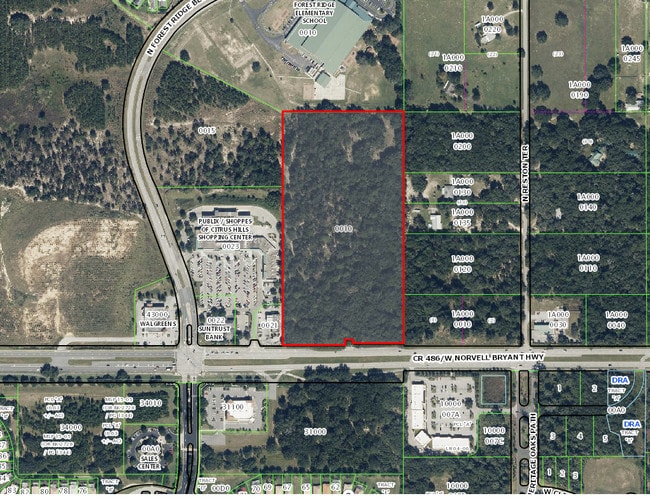
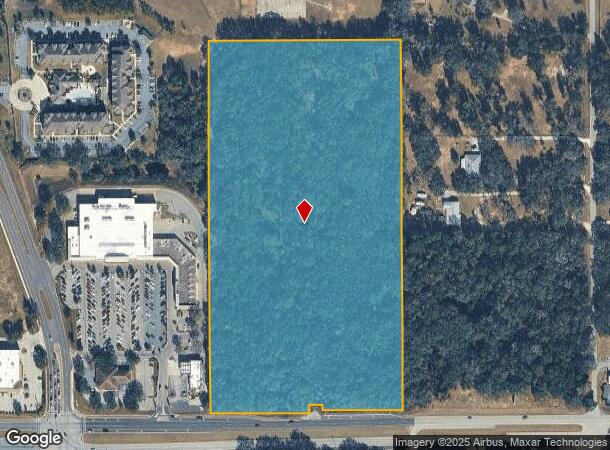
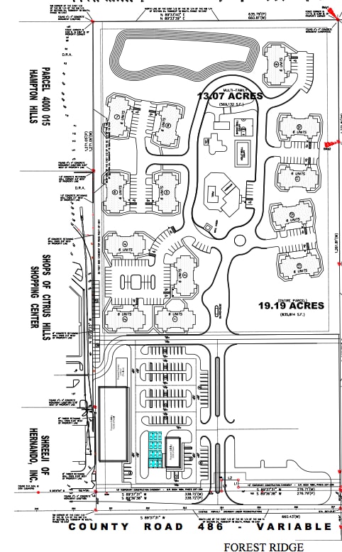
555 W Norvell Bryant Hwy
Homosassa Springs, FL
Unrec Tracts In 24-18S-18E
18E-18S-24-0000-4A000-0010
A PORTION OF THE EAST 1/2 OF THE SOUTHEAST 1/4 OF THE NORTHWEST 1/4 OF SECTION 24 TOWNSHIP 18 SOUTH RANGE 18 EAST CITRUS COUNTY FLORIDA BEING MORE PARTICULARLY DESCRIBED AS FOLLOWS: COMMENCE AT THE SOUTHEAST CORNER OF THE EAST 1/2 OF THE SOUTHEAST 1/
Commercialacreage
Citrus
X
Florida
12017C0214D
10
2024
19.25 AC
2025
Florida Central North Area
450104
Other Market Areas
DEMOGRAPHICS near 555 W Norvell Bryant Hwy
1 Mile
3 Mile
5 Mile
2024 Total Population
4,523
27,906
45,324
2029 Population
5,167
31,559
51,385
Pop Growth 2024-2029
+ 14.24%
+ 13.09%
+ 13.37%
Average Age
59
54
53
2024 Total Households
2,163
12,776
20,376
HH Growth 2024-2029
+ 14.05%
+ 12.86%
+ 13.12%
Median Household Inc
$56,946
$48,996
$51,926
Avg Household Size
2.00
2.10
2.10
2024 Avg HH Vehicles
2.00
2.00
2.00
Median Home Value
$264,939
$233,606
$236,207
Median Year Built
1999
1990
1993
Nearby Places
Map Layers
Map Styles
 Street
 Aerial
- Restaurants
- Banks
- Shops
- Fitness
- Groceries
SALE & LEASE HISTORY
LISTING DATE
SALE/LEASE

Sep 24, 2016
For Sale
Feb 27, 2017
For Sale
Nearby Properties
Address
Land Use
TOTAL SIZE
Lot Size
Zoning
Address
Land Use
TOTAL SIZE
Lot Size
Zoning
840,664 SF
6.64 AC
PDR
Address
Land Use
TOTAL SIZE
Lot Size
Zoning
135,334 SF
11.45 AC
GNC
Address
Land Use
TOTAL SIZE
Lot Size
Zoning
901,824 SF
14.37 AC
GNC
Address
Land Use
TOTAL SIZE
Lot Size
Zoning
114,484 SF
20.07 AC
PDR
Address
Land Use
TOTAL SIZE
Lot Size
Zoning
66,513 SF
31.85 AC
PSI
Address
Land Use
TOTAL SIZE
Lot Size
Zoning
167,220 SF
9.09 AC
GNC
Address
Land Use
TOTAL SIZE
Lot Size
Zoning
300,060 SF
8.74 AC
PDR
Address
Land Use
TOTAL SIZE
Lot Size
Zoning
178,134 SF
10.77 AC
PDR
Address
Land Use
TOTAL SIZE
Lot Size
Zoning
447,538 SF
7.06 AC
PDR
Address
Land Use
TOTAL SIZE
Lot Size
Zoning
345,488 SF
5.87 AC
PDR
Address
Land Use
TOTAL SIZE
Lot Size
Zoning
55,949 SF
4.71 AC
GNC
Address
Land Use
TOTAL SIZE
Lot Size
Zoning
42,134 SF
4.52 AC
GNC
Address
Land Use
TOTAL SIZE
Lot Size
Zoning
164,940 SF
10.36 AC
PDR
Address
Land Use
TOTAL SIZE
Lot Size
Zoning
53,425 SF
5.18 AC
PDR
Address
Land Use
TOTAL SIZE
Lot Size
Zoning
13,025 SF
1.93 AC
PDR
Address
Land Use
TOTAL SIZE
Lot Size
Zoning
155,752 SF
32.74 AC
PDR
Address
Land Use
TOTAL SIZE
Lot Size
Zoning
86,553 SF
7.78 AC
GNC
Address
Land Use
TOTAL SIZE
Lot Size
Zoning
76,562 SF
212.56 AC
PDR
Address
Land Use
TOTAL SIZE
Lot Size
Zoning
67,422 SF
4.01 AC
GNC
Address
Land Use
TOTAL SIZE
Lot Size
Zoning
20,492 SF
2.61 AC
GNC
Address
Land Use
TOTAL SIZE
Lot Size
Zoning
16,036 SF
2.42 AC
GNC
Address
Land Use
TOTAL SIZE
Lot Size
Zoning
13,577 SF
2.25 AC
PDR
Address
Land Use
TOTAL SIZE
Lot Size
Zoning
15.12 AC
GNC
Address
Land Use
TOTAL SIZE
Lot Size
Zoning
16,795 SF
1.84 AC
PDR
Address
Land Use
TOTAL SIZE
Lot Size
Zoning
17,844 SF
1.65 AC
GNC
Address
Land Use
TOTAL SIZE
Lot Size
Zoning
6,807 SF
3.64 AC
GNC
Address
Land Use
TOTAL SIZE
Lot Size
Zoning
20,492 SF
5.02 AC
PDR
Address
Land Use
TOTAL SIZE
Lot Size
Zoning
108,617 SF
7.59 AC
PDR
Address
Land Use
TOTAL SIZE
Lot Size
Zoning
8,738 SF
1.93 AC
GNC
Address
Land Use
TOTAL SIZE
Lot Size
Zoning
77,129 SF
2.84 AC
GNC
The World's #1 Commercial Real Estate Marketplace
Connect with us
© 2025 CoStar Group
The information above has been obtained from sources believed reliable. While we do not doubt its accuracy we have not verified it and make no guarantee, warranty or representation about it. It is your responsibility to independently confirm its accuracy and completeness. Any projections, opinions, assumptions, or estimates used are for example only and do not represent the current or future performance of the property. The value of this transaction to you depends on tax and other factors which should be evaluated by your tax, financial, and legal advisors. You and your advisors should conduct a careful, independent investigation of the property to determine to your satisfaction the suitability of the property for your needs.