Property Record
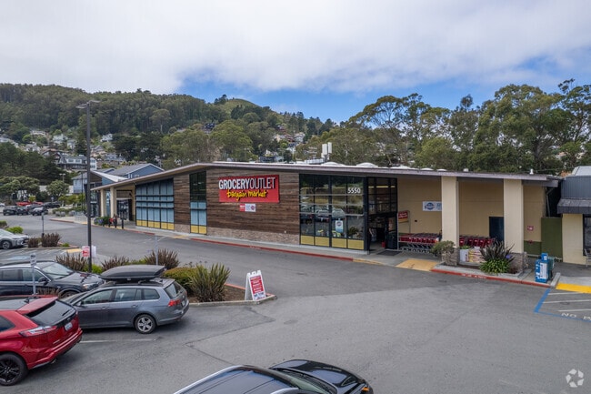
5550 Coast Hwy, Pacifica, CA 94044

Save to a Folder
{{folder.Name}}
{{folder.ListingIds.length}} Properties
{{folder.ListingIds.length}} Property
Create a New Folder
Property Detail
5550 Coast Hwy
023-072-070
1.50 AC MOL COM 120 FT NELY FR SAN PEDRO AVE & 59.67 FT SELY FR CHESTER WAY ACREAGE CITY OF PACIFICA
Supermarket
SAN MATEO
CL00C2
California
B and X Area of moderate flood hazard, usually the area between the limits of the 100-year and 500-year floods.
ix
2025
1.57 AC
2026
Peninsula Coastline
603200
San Francisco
20,408 SF
San Francisco-San Mateo-Redwood City, CA
NEARBY LISTINGS FOR SALE OR LEASE
DEMOGRAPHICS near 5550 Coast Hwy
1 mile
3 mile
5 mile
2025 Total Population
5,632
21,209
89,096
2030 Population
5,646
21,270
88,981
Pop Growth 2025-2030
+ 0.25%
+ 0.29%
(0.13%)
Average Age
44
45
44
2025 Total Households
2,053
8,022
31,172
HH Growth 2025-2030
+ 0.15%
+ 0.24%
(0.23%)
Median Household Inc
$146,736
$149,036
$150,788
Avg Household Size
2.70
2.60
2.80
2025 Avg HH Vehicles
2.00
2.00
2.00
Median Home Value
$1,111,224
$1,100,513
$1,084,609
Median Year Built
1958
1964
1967
Nearby Places
Map Layers
Map Styles
 Street
 Aerial
Layers
 Traffic
 Biking
Places
Listings with unknown addresses are not visible on the map
- Restaurants
- Banks
- Shops
- Fitness
- Groceries
PUBLIC TRANSPORTATION
COMMUTER RAIL
San Bruno Caltrain Station Southbound (Local Weekday - Caltrain (Caltrain), Local Weekend - Caltrain (Caltrain))
Drive
Walk
Distance
San Bruno Caltrain Station Southbound (Local Weekday - Caltrain (Caltrain), Local Weekend - Caltrain (Caltrain))
15 min
8.6 mi
AIRPORT
San Francisco International
Drive
Walk
Distance
San Francisco International
21 min
11.3 mi
Metro Oakland International
Drive
Walk
Distance
Metro Oakland International
51 min
36.0 mi
Freight Ports
Port of San Francisco
Drive
Walk
Distance
Port of San Francisco
27 min
18.7 mi
Nearby Properties
Address
Land Use
TOTAL SIZE
Lot Size
Zoning
Address
Land Use
TOTAL SIZE
Lot Size
Zoning
58,775 SF
3.04 AC
R30000
Address
Land Use
TOTAL SIZE
Lot Size
Zoning
144,294 SF
12.12 AC
CL00C1
Address
Land Use
TOTAL SIZE
Lot Size
Zoning
73,485 SF
3.94 AC
R30000
Address
Land Use
TOTAL SIZE
Lot Size
Zoning
83,760 SF
1.49 AC
R30000
Address
Land Use
TOTAL SIZE
Lot Size
Zoning
0.75 AC
Address
Land Use
TOTAL SIZE
Lot Size
Zoning
74,279 SF
2.28 AC
R30000
Address
Land Use
TOTAL SIZE
Lot Size
Zoning
74,815 SF
1.70 AC
Address
Land Use
TOTAL SIZE
Lot Size
Zoning
23,940 SF
0.55 AC
CL00C1
Address
Land Use
TOTAL SIZE
Lot Size
Zoning
9.10 AC
PF0000
Address
Land Use
TOTAL SIZE
Lot Size
Zoning
31,630 SF
0.99 AC
Address
Land Use
TOTAL SIZE
Lot Size
Zoning
31,630 SF
0.75 AC
Address
Land Use
TOTAL SIZE
Lot Size
Zoning
6.70 AC
Address
Land Use
TOTAL SIZE
Lot Size
Zoning
17,126 SF
0.58 AC
R30000
Address
Land Use
TOTAL SIZE
Lot Size
Zoning
18,088 SF
0.41 AC
Address
Land Use
TOTAL SIZE
Lot Size
Zoning
34,207 SF
1.72 AC
Address
Land Use
TOTAL SIZE
Lot Size
Zoning
2.63 AC
CL00C2
Address
Land Use
TOTAL SIZE
Lot Size
Zoning
7.56 AC
00099X
Address
Land Use
TOTAL SIZE
Lot Size
Zoning
8,312 SF
0.22 AC
Address
Land Use
TOTAL SIZE
Lot Size
Zoning
9,944 SF
0.34 AC
Address
Land Use
TOTAL SIZE
Lot Size
Zoning
8,239 SF
0.28 AC
Address
Land Use
TOTAL SIZE
Lot Size
Zoning
1,257 SF
171.30 AC
AB0005
Address
Land Use
TOTAL SIZE
Lot Size
Zoning
31,732 SF
0.68 AC
C10000
Address
Land Use
TOTAL SIZE
Lot Size
Zoning
9,987 SF
0.17 AC
Address
Land Use
TOTAL SIZE
Lot Size
Zoning
8,524 SF
0.21 AC
Address
Land Use
TOTAL SIZE
Lot Size
Zoning
16,230 SF
0.36 AC
C10000
Address
Land Use
TOTAL SIZE
Lot Size
Zoning
77,008 SF
6.04 AC
C1000P
Address
Land Use
TOTAL SIZE
Lot Size
Zoning
8,680 SF
0.18 AC
The World's #1 Commercial Real Estate Marketplace
Connect with us
© 2026 CoStar Group
The information above has been obtained from sources believed reliable. While we do not doubt its accuracy we have not verified it and make no guarantee, warranty or representation about it. It is your responsibility to independently confirm its accuracy and completeness. Any projections, opinions, assumptions, or estimates used are for example only and do not represent the current or future performance of the property. The value of this transaction to you depends on tax and other factors which should be evaluated by your tax, financial, and legal advisors. You and your advisors should conduct a careful, independent investigation of the property to determine to your satisfaction the suitability of the property for your needs.