Property Record
5550 E Mcdowell Rd, Mesa, AZ 85215
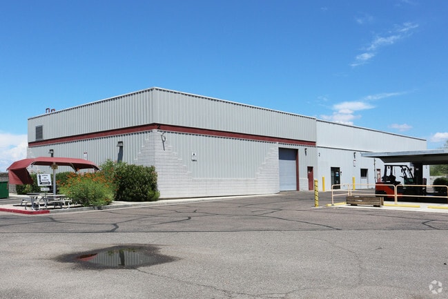

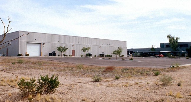
Property Detail
5550 E Mcdowell Rd
141-42-012
PT SW4 SEC 35 T2N R6E SHOWN AS PCL NO 1 P/F 21-0183357
Industrialgeneral
MARICOPA
C and X Area of minimal flood hazard, usually depicted on FIRMs as above the 500-year flood level.
Arizona
2025
3.06 AC
2025
Falcon Fld/Apache Jct
420206
Phoenix
23,600 SF
Phoenix-Mesa-Chandler, AZ
NEARBY LISTINGS FOR SALE OR LEASE
DEMOGRAPHICS near 5550 E Mcdowell Rd
1 mile
3 mile
5 mile
2024 Total Population
6,237
57,781
166,686
2029 Population
6,945
62,958
181,906
Pop Growth 2024-2029
+ 11.35%
+ 8.96%
+ 9.13%
Average Age
57
45
47
2024 Total Households
3,257
23,343
69,684
HH Growth 2024-2029
+ 11.73%
+ 9.24%
+ 9.63%
Median Household Inc
$60,130
$90,230
$72,990
Avg Household Size
1.80
2.40
2.30
2024 Avg HH Vehicles
1.00
2.00
2.00
Median Home Value
$298,010
$386,103
$345,559
Median Year Built
1988
1991
1989
Nearby Places
Map Layers
Map Styles
 Street
 Aerial
Transit
 Traffic
 Biking
Places
Listings with unknown addresses are not visible on the map
- Restaurants
- Banks
- Shops
- Fitness
- Groceries
PUBLIC TRANSPORTATION
AIRPORT
Phoenix-Mesa Gateway
Drive
Walk
Distance
Phoenix-Mesa Gateway
24 min
13.6 mi
Phoenix Sky Harbor International
Drive
Walk
Distance
Phoenix Sky Harbor International
27 min
19.8 mi
Freight Ports
Port of San Diego
Drive
Walk
Distance
Port of San Diego
423 min
379.1 mi
Nearby Properties
Address
Land Use
TOTAL SIZE
Lot Size
Zoning
Address
Land Use
TOTAL SIZE
Lot Size
Zoning
53,910 SF
4.98 AC
C-G
Address
Land Use
TOTAL SIZE
Lot Size
Zoning
1,691,248 SF
528.80 AC
I-1
Address
Land Use
TOTAL SIZE
Lot Size
Zoning
29.74 AC
Address
Land Use
TOTAL SIZE
Lot Size
Zoning
22.19 AC
Address
Land Use
TOTAL SIZE
Lot Size
Zoning
1,217,466 SF
102.41 AC
I-1
Address
Land Use
TOTAL SIZE
Lot Size
Zoning
22.71 AC
Address
Land Use
TOTAL SIZE
Lot Size
Zoning
271,098 SF
142.75 AC
PF
Address
Land Use
TOTAL SIZE
Lot Size
Zoning
161,388 SF
32.52 AC
R-35
Address
Land Use
TOTAL SIZE
Lot Size
Zoning
279,338 SF
39.90 AC
PF
Address
Land Use
TOTAL SIZE
Lot Size
Zoning
122,042 SF
15.79 AC
PF
Address
Land Use
TOTAL SIZE
Lot Size
Zoning
242,794 SF
14.29 AC
PEP
Address
Land Use
TOTAL SIZE
Lot Size
Zoning
66,350 SF
22.32 AC
I-1
Address
Land Use
TOTAL SIZE
Lot Size
Zoning
158,514 SF
21.39 AC
Address
Land Use
TOTAL SIZE
Lot Size
Zoning
8.82 AC
Address
Land Use
TOTAL SIZE
Lot Size
Zoning
359,204 SF
40.94 AC
LI
Address
Land Use
TOTAL SIZE
Lot Size
Zoning
7.90 AC
Address
Land Use
TOTAL SIZE
Lot Size
Zoning
214,197 SF
10.43 AC
RM3
Address
Land Use
TOTAL SIZE
Lot Size
Zoning
187,297 SF
3.99 AC
R-9
Address
Land Use
TOTAL SIZE
Lot Size
Zoning
4.79 AC
Address
Land Use
TOTAL SIZE
Lot Size
Zoning
7.26 AC
Address
Land Use
TOTAL SIZE
Lot Size
Zoning
225,233 SF
21.66 AC
C-G
Address
Land Use
TOTAL SIZE
Lot Size
Zoning
125,534 SF
19.59 AC
I-2
Address
Land Use
TOTAL SIZE
Lot Size
Zoning
146,107 SF
10.12 AC
LI
Address
Land Use
TOTAL SIZE
Lot Size
Zoning
157,048 SF
10.75 AC
Address
Land Use
TOTAL SIZE
Lot Size
Zoning
6.56 AC
Address
Land Use
TOTAL SIZE
Lot Size
Zoning
113,207 SF
6.87 AC
C-G
Address
Land Use
TOTAL SIZE
Lot Size
Zoning
157,592 SF
6.31 AC
C-G
Address
Land Use
TOTAL SIZE
Lot Size
Zoning
209,538 SF
13.47 AC
M-M
Address
Land Use
TOTAL SIZE
Lot Size
Zoning
168,861 SF
66.90 AC
R-90
Address
Land Use
TOTAL SIZE
Lot Size
Zoning
131,179 SF
13.24 AC
C-G
The World's #1 Commercial Real Estate Marketplace
Connect with us
© 2026 CoStar Group
The information above has been obtained from sources believed reliable. While we do not doubt its accuracy we have not verified it and make no guarantee, warranty or representation about it. It is your responsibility to independently confirm its accuracy and completeness. Any projections, opinions, assumptions, or estimates used are for example only and do not represent the current or future performance of the property. The value of this transaction to you depends on tax and other factors which should be evaluated by your tax, financial, and legal advisors. You and your advisors should conduct a careful, independent investigation of the property to determine to your satisfaction the suitability of the property for your needs.