Property Record
5550 N Main St, Baytown, TX 77521


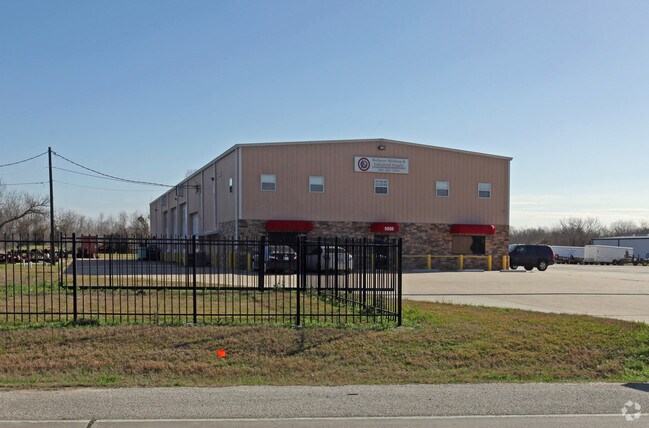

Property Detail
5550 N Main St
Houston-Pasadena-The Woodlands, TX
LT 1 BLK 1 RAMONS BUSINESS PARK
0421670000154
HARRIS
Warehouse
Texas
B and X Area of moderate flood hazard, usually the area between the limits of the 100-year and 500-year floods.
1
2024
4 AC
2025
East-Southeast Far
253202
Houston
12,000 SF
NEARBY LISTINGS FOR SALE OR LEASE
DEMOGRAPHICS near 5550 N Main St
1 mile
3 mile
5 mile
2025 Total Population
2,203
66,961
124,319
2030 Population
2,407
71,869
135,176
Pop Growth 2025-2030
+ 9.26%
+ 7.33%
+ 8.73%
Average Age
36
36
36
2025 Total Households
824
23,488
42,448
HH Growth 2025-2030
+ 9.59%
+ 7.47%
+ 8.75%
Median Household Inc
$73,538
$72,357
$70,256
Avg Household Size
2.60
2.80
2.90
2025 Avg HH Vehicles
2.00
2.00
2.00
Median Home Value
$245,600
$243,278
$233,475
Median Year Built
1994
1993
1990
Nearby Places
Map Layers
Map Styles
 Street
 Aerial
Layers
 Traffic
 Biking
Places
Listings with unknown addresses are not visible on the map
- Restaurants
- Banks
- Shops
- Fitness
- Groceries
PUBLIC TRANSPORTATION
AIRPORT
William P Hobby
Drive
Walk
Distance
William P Hobby
47 min
30.9 mi
George Bush Intcntl/Houston
Drive
Walk
Distance
George Bush Intcntl/Houston
45 min
36.1 mi
Freight Ports
Port of Houston
Drive
Walk
Distance
Port of Houston
35 min
24.0 mi
SALE & LEASE HISTORY
LISTING DATE
SALE/LEASE

Feb 07, 2024
For Sale
Nearby Properties
Address
Land Use
TOTAL SIZE
Lot Size
Zoning
Address
Land Use
TOTAL SIZE
Lot Size
Zoning
383,631 SF
22.45 AC
Address
Land Use
TOTAL SIZE
Lot Size
Zoning
323,413 SF
26.41 AC
Address
Land Use
TOTAL SIZE
Lot Size
Zoning
291,462 SF
13.43 AC
Address
Land Use
TOTAL SIZE
Lot Size
Zoning
352,067 SF
19.78 AC
Address
Land Use
TOTAL SIZE
Lot Size
Zoning
284,794 SF
10.18 AC
Address
Land Use
TOTAL SIZE
Lot Size
Zoning
251,498 SF
16.36 AC
Address
Land Use
TOTAL SIZE
Lot Size
Zoning
103.45 AC
Address
Land Use
TOTAL SIZE
Lot Size
Zoning
209,703 SF
11.18 AC
Address
Land Use
TOTAL SIZE
Lot Size
Zoning
225,497 SF
10.90 AC
Address
Land Use
TOTAL SIZE
Lot Size
Zoning
313,810 SF
20 AC
Address
Land Use
TOTAL SIZE
Lot Size
Zoning
238,488 SF
13 AC
Address
Land Use
TOTAL SIZE
Lot Size
Zoning
59.21 AC
Address
Land Use
TOTAL SIZE
Lot Size
Zoning
122,554 SF
12.85 AC
Address
Land Use
TOTAL SIZE
Lot Size
Zoning
71,560 SF
17.89 AC
Address
Land Use
TOTAL SIZE
Lot Size
Zoning
103,107 SF
15.56 AC
Address
Land Use
TOTAL SIZE
Lot Size
Zoning
205,859 SF
10.88 AC
Address
Land Use
TOTAL SIZE
Lot Size
Zoning
214,627 SF
13.77 AC
Address
Land Use
TOTAL SIZE
Lot Size
Zoning
247,218 SF
12.44 AC
Address
Land Use
TOTAL SIZE
Lot Size
Zoning
282,661 SF
14.68 AC
Address
Land Use
TOTAL SIZE
Lot Size
Zoning
270,282 SF
15.19 AC
Address
Land Use
TOTAL SIZE
Lot Size
Zoning
221,571 SF
21.28 AC
Address
Land Use
TOTAL SIZE
Lot Size
Zoning
69,976 SF
7.37 AC
Address
Land Use
TOTAL SIZE
Lot Size
Zoning
203,740 SF
12 AC
Address
Land Use
TOTAL SIZE
Lot Size
Zoning
43,228 SF
6.88 AC
Address
Land Use
TOTAL SIZE
Lot Size
Zoning
138,240 SF
2.95 AC
Address
Land Use
TOTAL SIZE
Lot Size
Zoning
94,350 SF
8 AC
Address
Land Use
TOTAL SIZE
Lot Size
Zoning
42,934 SF
2.60 AC
Address
Land Use
TOTAL SIZE
Lot Size
Zoning
224,472 SF
12 AC
Address
Land Use
TOTAL SIZE
Lot Size
Zoning
261,760 SF
12.62 AC
Address
Land Use
TOTAL SIZE
Lot Size
Zoning
83,772 SF
8.09 AC
The World's #1 Commercial Real Estate Marketplace
Connect with us
© 2026 CoStar Group
The information above has been obtained from sources believed reliable. While we do not doubt its accuracy we have not verified it and make no guarantee, warranty or representation about it. It is your responsibility to independently confirm its accuracy and completeness. Any projections, opinions, assumptions, or estimates used are for example only and do not represent the current or future performance of the property. The value of this transaction to you depends on tax and other factors which should be evaluated by your tax, financial, and legal advisors. You and your advisors should conduct a careful, independent investigation of the property to determine to your satisfaction the suitability of the property for your needs.