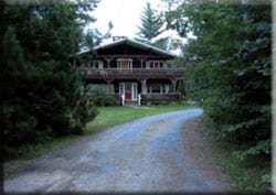
Property Record
5552 Nys Route 86, Wilmington, NY 12997
NEARBY LISTINGS FOR SALE OR LEASE
-
-
View all Wilmington listings for sale on LoopNet.com
Property Detail
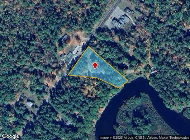
5552 Nys Route 86
155400-026-006-0005-067-200-0000
Essex
Apartment
New York
2024
67.200
2024
1.97 AC
960300
Upstate New York Area
5,272 SF
Other Market Areas
DEMOGRAPHICS near 5552 Nys Route 86
1 Mile
3 Mile
5 Mile
2024 Total Population
397
939
1,403
2029 Population
386
912
1,368
Pop Growth 2024-2029
(2.77%)
(2.88%)
(2.49%)
Average Age
47
47
46
2024 Total Households
178
420
618
HH Growth 2024-2029
(3.37%)
(3.10%)
(2.59%)
Median Household Inc
$70,908
$70,672
$71,302
Avg Household Size
2.30
2.20
2.30
2024 Avg HH Vehicles
2.00
2.00
2.00
Median Home Value
$288,888
$287,301
$243,939
Median Year Built
1966
1966
1969
Nearby Places
- Restaurants
- Banks
- Shops
- Fitness
- Groceries
PUBLIC TRANSPORTATION
AIRPORT
Plattsburgh International
DRIVE
WALK
Distance
Plattsburgh International
54 min
37.2 mi
Nearby Properties
Address
Land Use
TOTAL SIZE
Lot Size
Zoning
Address
Land Use
TOTAL SIZE
Lot Size
Zoning
2,304 SF
7.50 AC
07 - MIXED
Address
Land Use
TOTAL SIZE
Lot Size
Zoning
0.01 AC
01 - NOT Z
Address
Land Use
TOTAL SIZE
Lot Size
Zoning
2,760 SF
2.80 AC
07 - MIXED
Address
Land Use
TOTAL SIZE
Lot Size
Zoning
25,591 SF
2.70 AC
07 - MIXED
Address
Land Use
TOTAL SIZE
Lot Size
Zoning
7,440 SF
0.01 AC
08 - GOVER
Address
Land Use
TOTAL SIZE
Lot Size
Zoning
6.90 AC
07 - MIXED
Address
Land Use
TOTAL SIZE
Lot Size
Zoning
3,284 SF
106.50 AC
07 - MIXED
Address
Land Use
TOTAL SIZE
Lot Size
Zoning
2,664 SF
6.70 AC
07 - MIXED
Address
Land Use
TOTAL SIZE
Lot Size
Zoning
10,256 SF
1.80 AC
01 - NOT Z
Address
Land Use
TOTAL SIZE
Lot Size
Zoning
10,000 SF
3.63 AC
07 - MIXED
Address
Land Use
TOTAL SIZE
Lot Size
Zoning
7,440 SF
0.01 AC
08 - GOVER
Address
Land Use
TOTAL SIZE
Lot Size
Zoning
14,958 SF
64.59 AC
07 - MIXED
Address
Land Use
TOTAL SIZE
Lot Size
Zoning
14,282 SF
5 AC
07 - MIXED
Address
Land Use
TOTAL SIZE
Lot Size
Zoning
957 SF
87.50 AC
02 - SINGL
Address
Land Use
TOTAL SIZE
Lot Size
Zoning
2,844 SF
7.81 AC
02 - SINGL
Address
Land Use
TOTAL SIZE
Lot Size
Zoning
4,620 SF
143.40 AC
07 - MIXED
Address
Land Use
TOTAL SIZE
Lot Size
Zoning
1,499 SF
5.40 AC
02 - SINGL
Address
Land Use
TOTAL SIZE
Lot Size
Zoning
4,863 SF
92 AC
07 - MIXED
Address
Land Use
TOTAL SIZE
Lot Size
Zoning
1,968 SF
43.66 AC
02 - SINGL
Address
Land Use
TOTAL SIZE
Lot Size
Zoning
13,299 SF
6.96 AC
07 - MIXED
Address
Land Use
TOTAL SIZE
Lot Size
Zoning
2,732 SF
8.81 AC
02 - SINGL
Address
Land Use
TOTAL SIZE
Lot Size
Zoning
11,204 SF
40.80 AC
01 - NOT Z
Address
Land Use
TOTAL SIZE
Lot Size
Zoning
1,946 SF
6.70 AC
02 - SINGL
Address
Land Use
TOTAL SIZE
Lot Size
Zoning
5,480 SF
4 AC
07 - MIXED
Address
Land Use
TOTAL SIZE
Lot Size
Zoning
4,699 SF
2.40 AC
07 - MIXED
Address
Land Use
TOTAL SIZE
Lot Size
Zoning
3,416 SF
12.56 AC
01 - NOT Z
Address
Land Use
TOTAL SIZE
Lot Size
Zoning
3,753 SF
1.80 AC
07 - MIXED
Address
Land Use
TOTAL SIZE
Lot Size
Zoning
2,000 SF
0.85 AC
07 - MIXED
Address
Land Use
TOTAL SIZE
Lot Size
Zoning
3,358 SF
51.30 AC
02 - SINGL
Address
Land Use
TOTAL SIZE
Lot Size
Zoning
3,310 SF
14.80 AC
07 - MIXED
The World's #1 Commercial Real Estate Marketplace
Connect with us
© 2025 CoStar Group
The information above has been obtained from sources believed reliable. While we do not doubt its accuracy we have not verified it and make no guarantee, warranty or representation about it. It is your responsibility to independently confirm its accuracy and completeness. Any projections, opinions, assumptions, or estimates used are for example only and do not represent the current or future performance of the property. The value of this transaction to you depends on tax and other factors which should be evaluated by your tax, financial, and legal advisors. You and your advisors should conduct a careful, independent investigation of the property to determine to your satisfaction the suitability of the property for your needs.