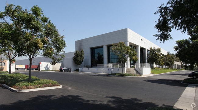
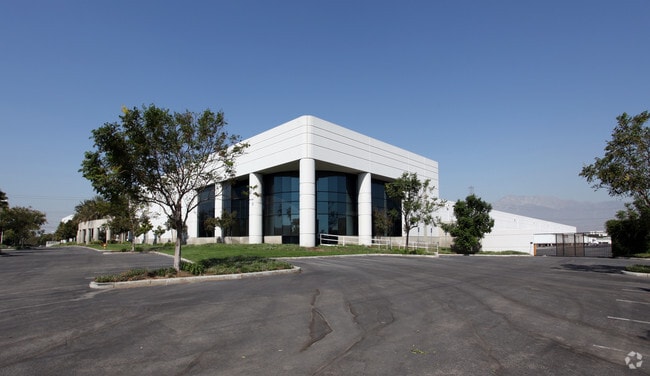
Property Record
5555 Jurupa St, Ontario, CA 91761


NEARBY LISTINGS FOR SALE OR LEASE
-
-
-
-
-
-
-
-
-
-
-
-
-
-
-
-
-
10513-10567 San Sevaine Way
Jurupa Valley, CA 91752
$3,222,139 - $3,427,861
10,212 - 10,864 SF
Industrial
-
-
-
-
View all Ontario listings for sale on LoopNet.com
Property Detail
5555 Jurupa St
0238-101-11
PTN SE 1/4 SEC 29 TP 1S R 6W COM SW COR SD SE 1/4 TH N 1130 FT TH E 1155 FT TH S 1130 FT TH W 1155 FT TO POB EX THAT PTN LYING NWLY OF LI 75 FT SELY OF MEAS PARALLEL WITH AND AT RIGHT ANGLES TO LI DESC AS COM AT PT IN S LI SD SEC S 89 DEG 55 MIN 57 S
Warehouse
San Bernardino
X
California
06071C8642J
23.10 AC
2024
Airport Area
2025
Inland Empire (California)
012700
Riverside-San Bernardino-Ontario, CA
459,431 SF
DEMOGRAPHICS near 5555 Jurupa St
1 Mile
3 Mile
5 Mile
2024 Total Population
0
31,713
208,771
2029 Population
0
32,369
213,673
Pop Growth 2024-2029
0.00%
+ 2.07%
+ 2.35%
Average Age
0
37
36
2024 Total Households
0
9,608
60,400
HH Growth 2024-2029
0.00%
+ 2.58%
+ 2.32%
Median Household Inc
$0
$80,684
$91,614
Avg Household Size
.00
3.00
3.30
2024 Avg HH Vehicles
.00
2.00
2.00
Median Home Value
$0
$430,570
$485,931
Median Year Built
0
1986
1990
Nearby Places
Map Layers
Map Styles
 Street
 Aerial
- Restaurants
- Banks
- Shops
- Fitness
- Groceries
PUBLIC TRANSPORTATION
COMMUTER RAIL
East Ontario (Riverside Line - Southern California Regional Rail Authority (Metrolink))
DRIVE
WALK
Distance
East Ontario (Riverside Line - Southern California Regional Rail Authority (Metrolink))
8 min
3.7 mi
Rancho Cucamonga (San Bernardino Line - Southern California Regional Rail Authority (Metrolink))
DRIVE
WALK
Distance
Rancho Cucamonga (San Bernardino Line - Southern California Regional Rail Authority (Metrolink))
10 min
4.9 mi
AIRPORT
Ontario International
DRIVE
WALK
Distance
Ontario International
11 min
5.6 mi
John Wayne/Orange County
DRIVE
WALK
Distance
John Wayne/Orange County
52 min
41.4 mi
Nearby Properties
Address
Land Use
TOTAL SIZE
Lot Size
Zoning
Address
Land Use
TOTAL SIZE
Lot Size
Zoning
1,459,702 SF
96.41 AC
Address
Land Use
TOTAL SIZE
Lot Size
Zoning
1,422,524 SF
44.96 AC
Address
Land Use
TOTAL SIZE
Lot Size
Zoning
362.37 AC
Address
Land Use
TOTAL SIZE
Lot Size
Zoning
1,379,287 SF
62.56 AC
Address
Land Use
TOTAL SIZE
Lot Size
Zoning
1,613,290 SF
59.42 AC
Address
Land Use
TOTAL SIZE
Lot Size
Zoning
707,551 SF
20.36 AC
Address
Land Use
TOTAL SIZE
Lot Size
Zoning
759,260 SF
42.77 AC
Address
Land Use
TOTAL SIZE
Lot Size
Zoning
817,750 SF
35.82 AC
Address
Land Use
TOTAL SIZE
Lot Size
Zoning
760,915 SF
30.34 AC
Address
Land Use
TOTAL SIZE
Lot Size
Zoning
912 SF
370.60 AC
IR
Address
Land Use
TOTAL SIZE
Lot Size
Zoning
752,497 SF
24.89 AC
Address
Land Use
TOTAL SIZE
Lot Size
Zoning
1,385,866 SF
69.84 AC
Address
Land Use
TOTAL SIZE
Lot Size
Zoning
34.80 AC
Address
Land Use
TOTAL SIZE
Lot Size
Zoning
329,831 SF
15.51 AC
MSC
Address
Land Use
TOTAL SIZE
Lot Size
Zoning
489,989 SF
24.49 AC
Address
Land Use
TOTAL SIZE
Lot Size
Zoning
500,403 SF
24.69 AC
Address
Land Use
TOTAL SIZE
Lot Size
Zoning
453,960 SF
18.54 AC
Address
Land Use
TOTAL SIZE
Lot Size
Zoning
560,025 SF
25.85 AC
Address
Land Use
TOTAL SIZE
Lot Size
Zoning
591,495 SF
18.29 AC
Address
Land Use
TOTAL SIZE
Lot Size
Zoning
319,375 SF
14.66 AC
Address
Land Use
TOTAL SIZE
Lot Size
Zoning
210,615 SF
9.42 AC
MM
Address
Land Use
TOTAL SIZE
Lot Size
Zoning
286,732 SF
9.58 AC
Address
Land Use
TOTAL SIZE
Lot Size
Zoning
901,662 SF
33.87 AC
IP
Address
Land Use
TOTAL SIZE
Lot Size
Zoning
300,205 SF
12.63 AC
Address
Land Use
TOTAL SIZE
Lot Size
Zoning
235,781 SF
10.80 AC
Address
Land Use
TOTAL SIZE
Lot Size
Zoning
76.50 AC
Address
Land Use
TOTAL SIZE
Lot Size
Zoning
317,070 SF
14.26 AC
Address
Land Use
TOTAL SIZE
Lot Size
Zoning
256,308 SF
11.36 AC
Address
Land Use
TOTAL SIZE
Lot Size
Zoning
19,440 SF
20.95 AC
M2
The World's #1 Commercial Real Estate Marketplace
Connect with us
© 2026 CoStar Group
The information above has been obtained from sources believed reliable. While we do not doubt its accuracy we have not verified it and make no guarantee, warranty or representation about it. It is your responsibility to independently confirm its accuracy and completeness. Any projections, opinions, assumptions, or estimates used are for example only and do not represent the current or future performance of the property. The value of this transaction to you depends on tax and other factors which should be evaluated by your tax, financial, and legal advisors. You and your advisors should conduct a careful, independent investigation of the property to determine to your satisfaction the suitability of the property for your needs.