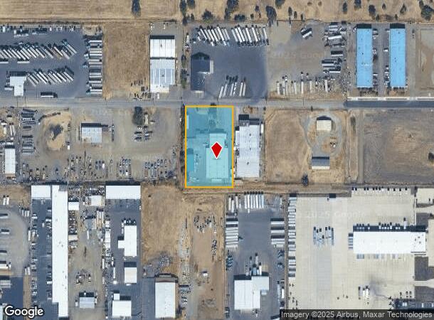
Property Record
5558 Table Rock Rd, Central Point, OR 97502

NEARBY LISTINGS FOR SALE OR LEASE
Property Detail
5558 Table Rock Rd
10646134
Table Rock Road Indust Park
Industrialgeneral
Jackson
X
Oregon
41029C1769F
8
2025
1.46 AC
2026
Medford/Grants Pass
001301
Other Market Areas
12,784 SF
Medford, OR
DEMOGRAPHICS near 5558 Table Rock Rd
1 Mile
3 Mile
5 Mile
2024 Total Population
2,174
30,863
83,360
2029 Population
2,163
30,752
83,150
Pop Growth 2024-2029
(0.51%)
(0.36%)
(0.25%)
Average Age
42
40
40
2024 Total Households
757
11,589
31,653
HH Growth 2024-2029
(0.66%)
(0.42%)
(0.31%)
Median Household Inc
$73,084
$69,680
$63,372
Avg Household Size
2.80
2.60
2.50
2024 Avg HH Vehicles
2.00
2.00
2.00
Median Home Value
$349,851
$310,126
$316,515
Median Year Built
1995
1991
1983
Nearby Places
Map Layers
Map Styles
 Street
 Aerial
- Restaurants
- Banks
- Shops
- Fitness
- Groceries
PUBLIC TRANSPORTATION
AIRPORT
Rogue Valley International - Medford
DRIVE
WALK
Distance
Rogue Valley International - Medford
6 min
2.5 mi
SALE & LEASE HISTORY
LISTING DATE
SALE/LEASE

Oct 04, 2021
For Sale
Nearby Properties
Address
Land Use
TOTAL SIZE
Lot Size
Zoning
Address
Land Use
TOTAL SIZE
Lot Size
Zoning
290.83 AC
I-L
Address
Land Use
TOTAL SIZE
Lot Size
Zoning
49.38 AC
GI
Address
Land Use
TOTAL SIZE
Lot Size
Zoning
30.66 AC
GI
Address
Land Use
TOTAL SIZE
Lot Size
Zoning
69.89 AC
GI
Address
Land Use
TOTAL SIZE
Lot Size
Zoning
600,000 SF
18.27 AC
M-1
Address
Land Use
TOTAL SIZE
Lot Size
Zoning
14.84 AC
GI
Address
Land Use
TOTAL SIZE
Lot Size
Zoning
73.48 AC
GI
Address
Land Use
TOTAL SIZE
Lot Size
Zoning
2,088 SF
41.88 AC
OSR
Address
Land Use
TOTAL SIZE
Lot Size
Zoning
88,434 SF
12.10 AC
I-L
Address
Land Use
TOTAL SIZE
Lot Size
Zoning
125,910 SF
14.29 AC
C-R
Address
Land Use
TOTAL SIZE
Lot Size
Zoning
30.87 AC
CIVIC
Address
Land Use
TOTAL SIZE
Lot Size
Zoning
88.67 AC
I-L
Address
Land Use
TOTAL SIZE
Lot Size
Zoning
136,756 SF
12.50 AC
C-R
Address
Land Use
TOTAL SIZE
Lot Size
Zoning
177.42 AC
GI
Address
Land Use
TOTAL SIZE
Lot Size
Zoning
49 AC
GI
Address
Land Use
TOTAL SIZE
Lot Size
Zoning
50.78 AC
GI
Address
Land Use
TOTAL SIZE
Lot Size
Zoning
35,272 SF
10.01 AC
GI
Address
Land Use
TOTAL SIZE
Lot Size
Zoning
6,039 SF
5.26 AC
MMR
Address
Land Use
TOTAL SIZE
Lot Size
Zoning
13.49 AC
M-1
Address
Land Use
TOTAL SIZE
Lot Size
Zoning
25.77 AC
GI
Address
Land Use
TOTAL SIZE
Lot Size
Zoning
31,283 SF
2.95 AC
I-L
Address
Land Use
TOTAL SIZE
Lot Size
Zoning
144,396 SF
10.67 AC
C-R
Address
Land Use
TOTAL SIZE
Lot Size
Zoning
102,184 SF
5.82 AC
I-L
Address
Land Use
TOTAL SIZE
Lot Size
Zoning
98,547 SF
4.36 AC
I-L
Address
Land Use
TOTAL SIZE
Lot Size
Zoning
37.62 AC
GI
Address
Land Use
TOTAL SIZE
Lot Size
Zoning
60,561 SF
2.72 AC
HMR
Address
Land Use
TOTAL SIZE
Lot Size
Zoning
54,823 SF
15.17 AC
I-L
Address
Land Use
TOTAL SIZE
Lot Size
Zoning
45,406 SF
3.29 AC
MFR-15
Address
Land Use
TOTAL SIZE
Lot Size
Zoning
32,614 SF
8.27 AC
M-1
The World's #1 Commercial Real Estate Marketplace
Connect with us
© 2026 CoStar Group
The information above has been obtained from sources believed reliable. While we do not doubt its accuracy we have not verified it and make no guarantee, warranty or representation about it. It is your responsibility to independently confirm its accuracy and completeness. Any projections, opinions, assumptions, or estimates used are for example only and do not represent the current or future performance of the property. The value of this transaction to you depends on tax and other factors which should be evaluated by your tax, financial, and legal advisors. You and your advisors should conduct a careful, independent investigation of the property to determine to your satisfaction the suitability of the property for your needs.