Property Record
5561 Carpenter Rd, Ypsilanti, MI 48197
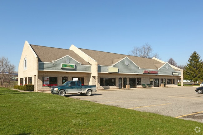


Property Detail
5561 Carpenter Rd
12-24-300-007
OLD SID - L 12-024-048-10 PI 24-16B-2B COM AT SW COR OF SEC 24, TH N 0-6-51 W 2105.5 FT ON W/L OF SEC TO POB, TH N 0-6-51 W
Stripcommercialcenter
Washtenaw
BI
Michigan
B and X Area of moderate flood hazard, usually the area between the limits of the 100-year and 500-year floods.
1.25 AC
2025
Washtenaw E of 23
2025
Detroit
416000
Ann Arbor, MI
7,632 SF
NEARBY LISTINGS FOR SALE OR LEASE
DEMOGRAPHICS near 5561 Carpenter Rd
1 mile
3 mile
5 mile
2025 Total Population
4,829
35,284
128,617
2030 Population
4,749
35,382
132,020
Pop Growth 2025-2030
(1.66%)
+ 0.28%
+ 2.65%
Average Age
38
39
38
2025 Total Households
1,867
14,216
54,448
HH Growth 2025-2030
(1.71%)
+ 0.20%
+ 2.71%
Median Household Inc
$100,950
$78,782
$76,333
Avg Household Size
2.50
2.30
2.20
2025 Avg HH Vehicles
2.00
2.00
2.00
Median Home Value
$309,594
$315,592
$328,916
Median Year Built
1995
1980
1981
Nearby Places
Map Layers
Map Styles
 Street
 Aerial
Layers
 Traffic
 Biking
Places
Listings with unknown addresses are not visible on the map
- Restaurants
- Banks
- Shops
- Fitness
- Groceries
PUBLIC TRANSPORTATION
COMMUTER RAIL
Drive
Walk
Distance
15 min
8.2 mi
AIRPORT
Detroit Metro Wayne County
Drive
Walk
Distance
Detroit Metro Wayne County
31 min
22.1 mi
Freight Ports
Drive
Walk
Distance
69 min
52.8 mi
SALE & LEASE HISTORY
LISTING DATE
SALE/LEASE

Sep 24, 2016
For Sale
Sep 02, 2022
For Sale
Nov 17, 2016
For Sale
Nearby Properties
Address
Land Use
TOTAL SIZE
Lot Size
Zoning
Address
Land Use
TOTAL SIZE
Lot Size
Zoning
36,000 SF
27.61 AC
BI
Address
Land Use
TOTAL SIZE
Lot Size
Zoning
112,994 SF
45.12 AC
IH
Address
Land Use
TOTAL SIZE
Lot Size
Zoning
140,039 SF
Address
Land Use
TOTAL SIZE
Lot Size
Zoning
37,500 SF
25.94 AC
BI
Address
Land Use
TOTAL SIZE
Lot Size
Zoning
253,702 SF
30.23 AC
Address
Land Use
TOTAL SIZE
Lot Size
Zoning
17,672 SF
33.37 AC
BI
Address
Land Use
TOTAL SIZE
Lot Size
Zoning
32,040 SF
22.33 AC
BI
Address
Land Use
TOTAL SIZE
Lot Size
Zoning
27,603 SF
35.42 AC
BI
Address
Land Use
TOTAL SIZE
Lot Size
Zoning
111,435 SF
21.38 AC
R4B
Address
Land Use
TOTAL SIZE
Lot Size
Zoning
18,148 SF
21.62 AC
BI
Address
Land Use
TOTAL SIZE
Lot Size
Zoning
13,224 SF
24.30 AC
BI
Address
Land Use
TOTAL SIZE
Lot Size
Zoning
167,294 SF
40.67 AC
Address
Land Use
TOTAL SIZE
Lot Size
Zoning
159,947 SF
14.19 AC
Address
Land Use
TOTAL SIZE
Lot Size
Zoning
132,937 SF
13.92 AC
R4A
Address
Land Use
TOTAL SIZE
Lot Size
Zoning
8.02 AC
R4B
Address
Land Use
TOTAL SIZE
Lot Size
Zoning
18,110 SF
14.80 AC
BI
Address
Land Use
TOTAL SIZE
Lot Size
Zoning
1,344 SF
18.17 AC
SPLIT
Address
Land Use
TOTAL SIZE
Lot Size
Zoning
222,002 SF
26.04 AC
Address
Land Use
TOTAL SIZE
Lot Size
Zoning
159,208 SF
18.73 AC
R3
Address
Land Use
TOTAL SIZE
Lot Size
Zoning
119,320 SF
6.13 AC
ME
Address
Land Use
TOTAL SIZE
Lot Size
Zoning
12,747 SF
22.86 AC
BA
Address
Land Use
TOTAL SIZE
Lot Size
Zoning
32,974 SF
29.96 AC
BA
Address
Land Use
TOTAL SIZE
Lot Size
Zoning
17,228 SF
8.40 AC
Address
Land Use
TOTAL SIZE
Lot Size
Zoning
11,630 SF
17.36 AC
BA
Address
Land Use
TOTAL SIZE
Lot Size
Zoning
259,778 SF
25.39 AC
Address
Land Use
TOTAL SIZE
Lot Size
Zoning
132,379 SF
27.35 AC
Address
Land Use
TOTAL SIZE
Lot Size
Zoning
4,964 SF
5.86 AC
Address
Land Use
TOTAL SIZE
Lot Size
Zoning
67,220 SF
9 AC
Address
Land Use
TOTAL SIZE
Lot Size
Zoning
255,838 SF
31.64 AC
II
Address
Land Use
TOTAL SIZE
Lot Size
Zoning
14,478 SF
7.51 AC
BI
The World's #1 Commercial Real Estate Marketplace
Connect with us
© 2026 CoStar Group
The information above has been obtained from sources believed reliable. While we do not doubt its accuracy we have not verified it and make no guarantee, warranty or representation about it. It is your responsibility to independently confirm its accuracy and completeness. Any projections, opinions, assumptions, or estimates used are for example only and do not represent the current or future performance of the property. The value of this transaction to you depends on tax and other factors which should be evaluated by your tax, financial, and legal advisors. You and your advisors should conduct a careful, independent investigation of the property to determine to your satisfaction the suitability of the property for your needs.