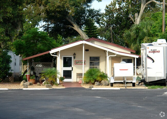
Property Record
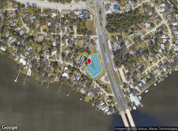
5561 W Bayshore Dr, Port Orange, FL 32127

NEARBY LISTINGS FOR SALE OR LEASE
Property Detail
5561 W Bayshore Dr
Deltona-Daytona Beach-Ormond Beach, FL
Harbor Oaks Unit 2
6340-01-17-0070
40-16-33 PER OR 8490 PG 1405 LOTS 6 7 8 12 13 AND 14 AND THE NORTHERLY 30 FEET OF LOT 5 BLOCK 17 EXCLUDING THAT PORTION OF LOTS 12 13 14 IN RIDGEWOOD AVENUE US #1 HARBOR OAKS UNIT 2 AS RECORDED IN MAP BOOK 10 PAGE 209 PUBLIC RECORDS OF VOLUSIA COUNTY
Vehiclerentalsvehiclesales
Volusia
X
Florida
12127C0526J
6,5
2025
0.95 AC
2025
South Beach Cities
082510
Deltona/Daytona Beach
1,845 SF
DEMOGRAPHICS near 5561 W Bayshore Dr
1 Mile
3 Mile
5 Mile
2024 Total Population
2,886
36,461
91,690
2029 Population
3,173
40,777
102,319
Pop Growth 2024-2029
+ 9.94%
+ 11.84%
+ 11.59%
Average Age
49
49
48
2024 Total Households
1,374
16,730
42,384
HH Growth 2024-2029
+ 10.12%
+ 12.30%
+ 11.97%
Median Household Inc
$52,025
$58,080
$59,099
Avg Household Size
2.00
2.10
2.10
2024 Avg HH Vehicles
2.00
2.00
2.00
Median Home Value
$191,437
$267,042
$260,675
Median Year Built
1974
1982
1986
Nearby Places
Map Layers
Map Styles
 Street
 Aerial
- Restaurants
- Banks
- Shops
- Fitness
- Groceries
PUBLIC TRANSPORTATION
AIRPORT
Daytona Beach International
DRIVE
WALK
Distance
Daytona Beach International
17 min
9.5 mi
Orlando Sanford International
DRIVE
WALK
Distance
Orlando Sanford International
58 min
40.2 mi
Freight Ports
Port Canaveral
DRIVE
WALK
Distance
Port Canaveral
82 min
68.8 mi
Nearby Properties
Address
Land Use
TOTAL SIZE
Lot Size
Zoning
Address
Land Use
TOTAL SIZE
Lot Size
Zoning
150,197 SF
16.07 AC
Address
Land Use
TOTAL SIZE
Lot Size
Zoning
94,338 SF
7.39 AC
Address
Land Use
TOTAL SIZE
Lot Size
Zoning
184,242 SF
14.43 AC
Address
Land Use
TOTAL SIZE
Lot Size
Zoning
269,160 SF
72.17 AC
16A
Address
Land Use
TOTAL SIZE
Lot Size
Zoning
9,061 SF
0.23 AC
16RMH
Address
Land Use
TOTAL SIZE
Lot Size
Zoning
3,886 SF
3.99 AC
16RMH
Address
Land Use
TOTAL SIZE
Lot Size
Zoning
173,765 SF
0.32 AC
Address
Land Use
TOTAL SIZE
Lot Size
Zoning
9,833 SF
52.38 AC
16RMH
Address
Land Use
TOTAL SIZE
Lot Size
Zoning
4,166 SF
51.05 AC
Address
Land Use
TOTAL SIZE
Lot Size
Zoning
212,681 SF
21.50 AC
Address
Land Use
TOTAL SIZE
Lot Size
Zoning
111,379 SF
16.62 AC
Address
Land Use
TOTAL SIZE
Lot Size
Zoning
138,930 SF
13.70 AC
16PCD
Address
Land Use
TOTAL SIZE
Lot Size
Zoning
80,836 SF
3.03 AC
R3
Address
Land Use
TOTAL SIZE
Lot Size
Zoning
102,229 SF
1.60 AC
Address
Land Use
TOTAL SIZE
Lot Size
Zoning
173,716 SF
6.76 AC
Address
Land Use
TOTAL SIZE
Lot Size
Zoning
1,940 SF
25.37 AC
Address
Land Use
TOTAL SIZE
Lot Size
Zoning
108,326 SF
7.03 AC
16R3H
Address
Land Use
TOTAL SIZE
Lot Size
Zoning
48,751 SF
5.28 AC
16PO
Address
Land Use
TOTAL SIZE
Lot Size
Zoning
87,320 SF
5.52 AC
Address
Land Use
TOTAL SIZE
Lot Size
Zoning
117,489 SF
20 AC
16A
Address
Land Use
TOTAL SIZE
Lot Size
Zoning
8,852 SF
0.25 AC
Address
Land Use
TOTAL SIZE
Lot Size
Zoning
27,477 SF
14.20 AC
Address
Land Use
TOTAL SIZE
Lot Size
Zoning
124,586 SF
11.09 AC
16CI
Address
Land Use
TOTAL SIZE
Lot Size
Zoning
99,055 SF
7.64 AC
16PCD
Address
Land Use
TOTAL SIZE
Lot Size
Zoning
77,941 SF
6.59 AC
16PCD
Address
Land Use
TOTAL SIZE
Lot Size
Zoning
52,712 SF
3.36 AC
Address
Land Use
TOTAL SIZE
Lot Size
Zoning
3,628 SF
0.23 AC
Address
Land Use
TOTAL SIZE
Lot Size
Zoning
36,249 SF
2.70 AC
Address
Land Use
TOTAL SIZE
Lot Size
Zoning
27,309 SF
3.77 AC
Address
Land Use
TOTAL SIZE
Lot Size
Zoning
100,642 SF
9.25 AC
16PCD
The World's #1 Commercial Real Estate Marketplace
Connect with us
© 2025 CoStar Group
The information above has been obtained from sources believed reliable. While we do not doubt its accuracy we have not verified it and make no guarantee, warranty or representation about it. It is your responsibility to independently confirm its accuracy and completeness. Any projections, opinions, assumptions, or estimates used are for example only and do not represent the current or future performance of the property. The value of this transaction to you depends on tax and other factors which should be evaluated by your tax, financial, and legal advisors. You and your advisors should conduct a careful, independent investigation of the property to determine to your satisfaction the suitability of the property for your needs.