Property Record
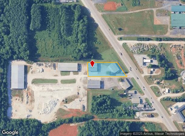
5565 Highway 53, Harvest, AL 35749

NEARBY LISTINGS FOR SALE OR LEASE
-
-
View all Harvest listings for lease on LoopNet.com
Property Detail
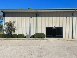
5565 Highway 53
06-07-26-0-000-079.081
Spacegate Commercial Park
Warehouse
SEC 26 T2S R2W TR 1: PT OF SEC 26 DESC AS COMM AT THE SW COR OF SD SEC 26 TH N 89 DEG E 2018.35 FT TH N 2573.73 FT TO THE POB
X
Madison
01089C0155F
Alabama
2025
1.25 AC
2025
North Madison County
010504
Huntsville
6,000 SF
Huntsville, AL
DEMOGRAPHICS near 5565 Highway 53
1 Mile
3 Mile
5 Mile
2024 Total Population
2,462
18,312
46,062
2029 Population
2,726
20,284
51,144
Pop Growth 2024-2029
+ 10.72%
+ 10.77%
+ 11.03%
Average Age
37
39
40
2024 Total Households
896
6,688
17,393
HH Growth 2024-2029
+ 11.16%
+ 11.26%
+ 11.46%
Median Household Inc
$124,297
$123,518
$107,317
Avg Household Size
2.70
2.70
2.60
2024 Avg HH Vehicles
2.00
2.00
2.00
Median Home Value
$295,404
$298,882
$274,959
Median Year Built
2003
2002
2002
Nearby Places
Map Layers
Map Styles
 Street
 Aerial
- Restaurants
- Banks
- Shops
- Fitness
- Groceries
PUBLIC TRANSPORTATION
AIRPORT
Huntsville International-Carl T Jones Field
DRIVE
WALK
Distance
Huntsville International-Carl T Jones Field
27 min
18.7 mi
SALE & LEASE HISTORY
LISTING DATE
SALE/LEASE

Nov 09, 2022
For Lease
Jan 15, 2024
For Lease
Jan 10, 2023
For Lease
Nearby Properties
Address
Land Use
TOTAL SIZE
Lot Size
Zoning
Address
Land Use
TOTAL SIZE
Lot Size
Zoning
36,514 SF
0.50 AC
RBC-4-PD(R
Address
Land Use
TOTAL SIZE
Lot Size
Zoning
14,544 SF
8.50 AC
Address
Land Use
TOTAL SIZE
Lot Size
Zoning
45,790 SF
13.39 AC
Address
Land Use
TOTAL SIZE
Lot Size
Zoning
Address
Land Use
TOTAL SIZE
Lot Size
Zoning
11,414 SF
7.60 AC
Address
Land Use
TOTAL SIZE
Lot Size
Zoning
22,990 SF
18 AC
Address
Land Use
TOTAL SIZE
Lot Size
Zoning
Address
Land Use
TOTAL SIZE
Lot Size
Zoning
10,882 SF
7.21 AC
Address
Land Use
TOTAL SIZE
Lot Size
Zoning
8,712 SF
1.55 AC
Address
Land Use
TOTAL SIZE
Lot Size
Zoning
1.46 AC
Address
Land Use
TOTAL SIZE
Lot Size
Zoning
10,739 SF
20 AC
Address
Land Use
TOTAL SIZE
Lot Size
Zoning
24,300 SF
9.28 AC
Address
Land Use
TOTAL SIZE
Lot Size
Zoning
30,000 SF
3.40 AC
Address
Land Use
TOTAL SIZE
Lot Size
Zoning
2.51 AC
Address
Land Use
TOTAL SIZE
Lot Size
Zoning
6,967 SF
3.25 AC
Address
Land Use
TOTAL SIZE
Lot Size
Zoning
5,760 SF
3.40 AC
Address
Land Use
TOTAL SIZE
Lot Size
Zoning
11,743 SF
0.95 AC
Address
Land Use
TOTAL SIZE
Lot Size
Zoning
10,000 SF
2.78 AC
Address
Land Use
TOTAL SIZE
Lot Size
Zoning
11,243 SF
9.10 AC
Address
Land Use
TOTAL SIZE
Lot Size
Zoning
7,870 SF
2.17 AC
Address
Land Use
TOTAL SIZE
Lot Size
Zoning
3,679 SF
1.31 AC
Address
Land Use
TOTAL SIZE
Lot Size
Zoning
3,511 SF
1.12 AC
Address
Land Use
TOTAL SIZE
Lot Size
Zoning
3,440 SF
1.49 AC
Address
Land Use
TOTAL SIZE
Lot Size
Zoning
6,280 SF
4.93 AC
Address
Land Use
TOTAL SIZE
Lot Size
Zoning
2,400 SF
0.89 AC
Address
Land Use
TOTAL SIZE
Lot Size
Zoning
1,152 SF
35 AC
Address
Land Use
TOTAL SIZE
Lot Size
Zoning
9,100 SF
1.68 AC
Address
Land Use
TOTAL SIZE
Lot Size
Zoning
2,790 SF
1.04 AC
Address
Land Use
TOTAL SIZE
Lot Size
Zoning
4.89 AC
LRLI
Address
Land Use
TOTAL SIZE
Lot Size
Zoning
8,164 SF
6.50 AC
The World's #1 Commercial Real Estate Marketplace
Connect with us
© 2025 CoStar Group
The information above has been obtained from sources believed reliable. While we do not doubt its accuracy we have not verified it and make no guarantee, warranty or representation about it. It is your responsibility to independently confirm its accuracy and completeness. Any projections, opinions, assumptions, or estimates used are for example only and do not represent the current or future performance of the property. The value of this transaction to you depends on tax and other factors which should be evaluated by your tax, financial, and legal advisors. You and your advisors should conduct a careful, independent investigation of the property to determine to your satisfaction the suitability of the property for your needs.