Property Record
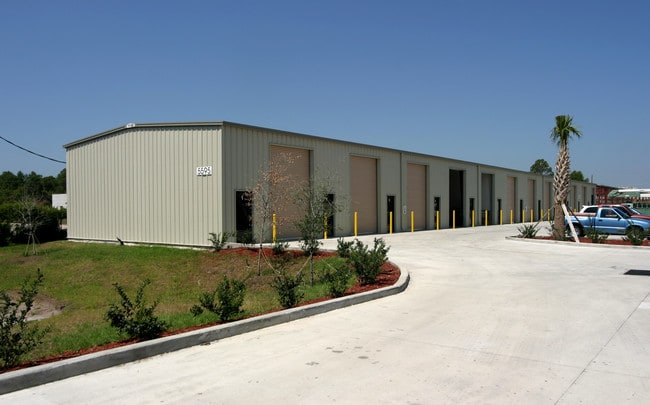
5565 Schenck Ave, Rockledge, FL 32955

NEARBY LISTINGS FOR SALE OR LEASE
-
-
View all Rockledge listings for sale on LoopNet.com
Property Detail
5565 Schenck Ave
25-36-35-00-00788.0-0000.00
PART OF NE 1/4 OF SE 1/4 AS DESC IN ORB 4213 PG 3649 1379 PAR 774.1
Truckterminal
Brevard
X
Florida
12009C0439H
3 AC
2024
Brevard County
2025
Orlando
063102
Palm Bay-Melbourne-Titusville, FL
38,400 SF
DEMOGRAPHICS near 5565 Schenck Ave
1 Mile
3 Mile
5 Mile
2024 Total Population
3,274
34,406
81,355
2029 Population
3,523
37,240
89,194
Pop Growth 2024-2029
+ 7.61%
+ 8.24%
+ 9.64%
Average Age
47
46
46
2024 Total Households
1,327
14,591
33,554
HH Growth 2024-2029
+ 7.39%
+ 8.07%
+ 9.34%
Median Household Inc
$117,376
$93,381
$93,581
Avg Household Size
2.40
2.30
2.40
2024 Avg HH Vehicles
2.00
2.00
2.00
Median Home Value
$354,599
$342,798
$356,730
Median Year Built
1995
1998
1999
Nearby Places
Map Layers
Map Styles
 Street
 Aerial
- Restaurants
- Banks
- Shops
- Fitness
- Groceries
PUBLIC TRANSPORTATION
AIRPORT
Melbourne Orlando International
DRIVE
WALK
Distance
Melbourne Orlando International
30 min
15.1 mi
Freight Ports
Port Canaveral
DRIVE
WALK
Distance
Port Canaveral
32 min
19.6 mi
Nearby Properties
Address
Land Use
TOTAL SIZE
Lot Size
Zoning
Address
Land Use
TOTAL SIZE
Lot Size
Zoning
520,272 SF
17.31 AC
Address
Land Use
TOTAL SIZE
Lot Size
Zoning
460,019 SF
11.64 AC
Address
Land Use
TOTAL SIZE
Lot Size
Zoning
406,986 SF
30.50 AC
PUD
Address
Land Use
TOTAL SIZE
Lot Size
Zoning
381,303 SF
9.93 AC
Address
Land Use
TOTAL SIZE
Lot Size
Zoning
395,806 SF
12.95 AC
Address
Land Use
TOTAL SIZE
Lot Size
Zoning
359,896 SF
13.29 AC
Address
Land Use
TOTAL SIZE
Lot Size
Zoning
358,615 SF
14.78 AC
PUD
Address
Land Use
TOTAL SIZE
Lot Size
Zoning
276,647 SF
2.39 AC
Address
Land Use
TOTAL SIZE
Lot Size
Zoning
308,045 SF
45.57 AC
PUD
Address
Land Use
TOTAL SIZE
Lot Size
Zoning
353,805 SF
44.02 AC
PUD
Address
Land Use
TOTAL SIZE
Lot Size
Zoning
269,541 SF
17.80 AC
PUD
Address
Land Use
TOTAL SIZE
Lot Size
Zoning
134,562 SF
18.25 AC
BU1
Address
Land Use
TOTAL SIZE
Lot Size
Zoning
16.29 AC
GML
Address
Land Use
TOTAL SIZE
Lot Size
Zoning
375,112 SF
30.84 AC
PUD
Address
Land Use
TOTAL SIZE
Lot Size
Zoning
136,205 SF
28.71 AC
PUD
Address
Land Use
TOTAL SIZE
Lot Size
Zoning
324,509 SF
23.54 AC
GMLI
Address
Land Use
TOTAL SIZE
Lot Size
Zoning
117,175 SF
8.06 AC
C2
Address
Land Use
TOTAL SIZE
Lot Size
Zoning
162,977 SF
11.44 AC
GML
Address
Land Use
TOTAL SIZE
Lot Size
Zoning
112,095 SF
9.50 AC
C2
Address
Land Use
TOTAL SIZE
Lot Size
Zoning
86,852 SF
5.03 AC
Address
Land Use
TOTAL SIZE
Lot Size
Zoning
96,110 SF
49.65 AC
INH
Address
Land Use
TOTAL SIZE
Lot Size
Zoning
110,902 SF
10.67 AC
Address
Land Use
TOTAL SIZE
Lot Size
Zoning
213,915 SF
27.13 AC
BU1
Address
Land Use
TOTAL SIZE
Lot Size
Zoning
135,320 SF
16.54 AC
BU1
Address
Land Use
TOTAL SIZE
Lot Size
Zoning
104,705 SF
15.14 AC
PUD
Address
Land Use
TOTAL SIZE
Lot Size
Zoning
69,560 SF
9 AC
PUD
Address
Land Use
TOTAL SIZE
Lot Size
Zoning
170,721 SF
28.52 AC
PIP
Address
Land Use
TOTAL SIZE
Lot Size
Zoning
75,200 SF
4.14 AC
Address
Land Use
TOTAL SIZE
Lot Size
Zoning
68,428 SF
3.66 AC
Address
Land Use
TOTAL SIZE
Lot Size
Zoning
83,420 SF
5.94 AC
PUD
The World's #1 Commercial Real Estate Marketplace
Connect with us
© 2025 CoStar Group
The information above has been obtained from sources believed reliable. While we do not doubt its accuracy we have not verified it and make no guarantee, warranty or representation about it. It is your responsibility to independently confirm its accuracy and completeness. Any projections, opinions, assumptions, or estimates used are for example only and do not represent the current or future performance of the property. The value of this transaction to you depends on tax and other factors which should be evaluated by your tax, financial, and legal advisors. You and your advisors should conduct a careful, independent investigation of the property to determine to your satisfaction the suitability of the property for your needs.