Property Record
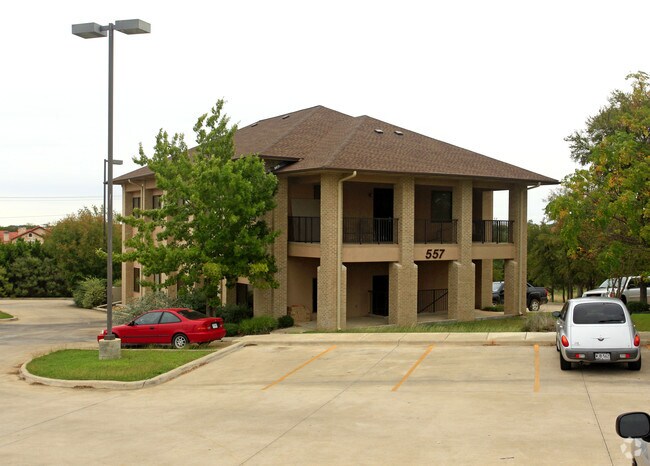
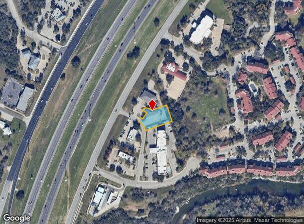
557 N Interstate 35, Georgetown, TX 78628


Property Detail
557 N Interstate 35
R453796
Imber Business Condo
Commercialnec
C710 - KIMBER BUSINESS CONDO, UNIT 2, 50% COMMON AREA INTEREST
X
Williamson
48491C0293F
Texas
2024
0.54 AC
2025
Georgetown
020114
Austin
5,095 SF
Austin-Round Rock-San Marcos, TX
NEARBY LISTINGS FOR SALE OR LEASE
DEMOGRAPHICS near 557 N Interstate 35
1 mile
3 mile
5 mile
2024 Total Population
7,732
49,206
96,412
2029 Population
9,962
63,097
123,689
Pop Growth 2024-2029
+ 28.84%
+ 28.23%
+ 28.29%
Average Age
42
40
40
2024 Total Households
3,409
19,331
37,316
HH Growth 2024-2029
+ 30.01%
+ 29.07%
+ 28.94%
Median Household Inc
$69,166
$82,663
$95,490
Avg Household Size
2.00
2.40
2.50
2024 Avg HH Vehicles
2.00
2.00
2.00
Median Home Value
$561,124
$367,233
$391,921
Median Year Built
2009
2000
2008
Nearby Places
Map Layers
Map Styles
 Street
 Aerial
Transit
 Traffic
 Biking
Places
Listings with unknown addresses are not visible on the map
- Restaurants
- Banks
- Shops
- Fitness
- Groceries
SALE & LEASE HISTORY
LISTING DATE
SALE/LEASE

Mar 16, 2023
For Lease
Feb 04, 2022
For Sale
Feb 03, 2022
For Sale
Nearby Properties
Address
Land Use
TOTAL SIZE
Lot Size
Zoning
Address
Land Use
TOTAL SIZE
Lot Size
Zoning
71.65 AC
1-RS
Address
Land Use
TOTAL SIZE
Lot Size
Zoning
145,000 SF
147.12 AC
Address
Land Use
TOTAL SIZE
Lot Size
Zoning
334,021 SF
50.48 AC
3-OF
Address
Land Use
TOTAL SIZE
Lot Size
Zoning
413,418 SF
50.48 AC
3-C-3
Address
Land Use
TOTAL SIZE
Lot Size
Zoning
431,200 SF
53.60 AC
3-C-3
Address
Land Use
TOTAL SIZE
Lot Size
Zoning
389,888 SF
30 AC
1-MF
Address
Land Use
TOTAL SIZE
Lot Size
Zoning
453,015 SF
22.62 AC
Address
Land Use
TOTAL SIZE
Lot Size
Zoning
393,202 SF
15.42 AC
Address
Land Use
TOTAL SIZE
Lot Size
Zoning
495,688 SF
20.31 AC
1-MF
Address
Land Use
TOTAL SIZE
Lot Size
Zoning
344,529 SF
14.07 AC
Address
Land Use
TOTAL SIZE
Lot Size
Zoning
450,880 SF
54.28 AC
Address
Land Use
TOTAL SIZE
Lot Size
Zoning
272,531 SF
14.97 AC
Address
Land Use
TOTAL SIZE
Lot Size
Zoning
233,173 SF
9.89 AC
Address
Land Use
TOTAL SIZE
Lot Size
Zoning
298,788 SF
24 AC
Address
Land Use
TOTAL SIZE
Lot Size
Zoning
307,473 SF
14.16 AC
Address
Land Use
TOTAL SIZE
Lot Size
Zoning
282,472 SF
11.79 AC
Address
Land Use
TOTAL SIZE
Lot Size
Zoning
294,214 SF
18.34 AC
Address
Land Use
TOTAL SIZE
Lot Size
Zoning
213,599 SF
5.01 AC
Address
Land Use
TOTAL SIZE
Lot Size
Zoning
268,556 SF
19.67 AC
Address
Land Use
TOTAL SIZE
Lot Size
Zoning
252,492 SF
15.35 AC
Address
Land Use
TOTAL SIZE
Lot Size
Zoning
316,931 SF
3.02 AC
Address
Land Use
TOTAL SIZE
Lot Size
Zoning
314,240 SF
16.03 AC
Address
Land Use
TOTAL SIZE
Lot Size
Zoning
241,804 SF
17.57 AC
3-C-3
Address
Land Use
TOTAL SIZE
Lot Size
Zoning
238,704 SF
19.85 AC
Address
Land Use
TOTAL SIZE
Lot Size
Zoning
205,554 SF
12.13 AC
3-C-3
Address
Land Use
TOTAL SIZE
Lot Size
Zoning
8,727 SF
89.67 AC
Address
Land Use
TOTAL SIZE
Lot Size
Zoning
186,337 SF
8.39 AC
Address
Land Use
TOTAL SIZE
Lot Size
Zoning
216,190 SF
15.09 AC
Address
Land Use
TOTAL SIZE
Lot Size
Zoning
610,222 SF
10.16 AC
Address
Land Use
TOTAL SIZE
Lot Size
Zoning
176,875 SF
14.75 AC
3-C-1
The World's #1 Commercial Real Estate Marketplace
Connect with us
© 2026 CoStar Group
The information above has been obtained from sources believed reliable. While we do not doubt its accuracy we have not verified it and make no guarantee, warranty or representation about it. It is your responsibility to independently confirm its accuracy and completeness. Any projections, opinions, assumptions, or estimates used are for example only and do not represent the current or future performance of the property. The value of this transaction to you depends on tax and other factors which should be evaluated by your tax, financial, and legal advisors. You and your advisors should conduct a careful, independent investigation of the property to determine to your satisfaction the suitability of the property for your needs.