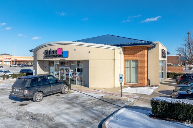
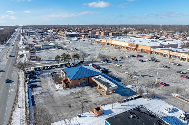
Property Record
5570 159Th St, Oak Forest, IL 60452
Current Lease Availabilities
NEARBY LISTINGS FOR SALE OR LEASE
Property Detail
5570 159Th St
Chicago-Naperville-Elgin, IL-IN-WI
Oak Forest Commons Resub
28-16-302-039-0000
Cook
Commercialbuilding
Illinois
X
1-6
17031C0707K
0.46 AC
2023
Near South Cook
2024
Chicago
825000
DEMOGRAPHICS near 5570 159Th St
1 Mile
3 Mile
5 Mile
2024 Total Population
12,210
81,620
227,484
2029 Population
11,834
79,720
222,655
Pop Growth 2024-2029
(3.08%)
(2.33%)
(2.12%)
Average Age
40
41
42
2024 Total Households
4,711
31,393
85,826
HH Growth 2024-2029
(3.40%)
(2.62%)
(2.38%)
Median Household Inc
$72,948
$72,711
$71,998
Avg Household Size
2.50
2.50
2.60
2024 Avg HH Vehicles
2.00
2.00
2.00
Median Home Value
$214,481
$217,926
$224,641
Median Year Built
1976
1974
1976
Nearby Places
Map Layers
Map Styles
 Street
 Aerial
- Restaurants
- Banks
- Shops
- Fitness
- Groceries
PUBLIC TRANSPORTATION
COMMUTER RAIL
Oak Forest Station (Rock Island District Line - Northeast Illinois Regional Commuter Railroad (Metra))
DRIVE
WALK
Distance
Oak Forest Station (Rock Island District Line - Northeast Illinois Regional Commuter Railroad (Metra))
3 min
20 min
1.1 mi
Tinley Park Station (Rock Island District Line - Northeast Illinois Regional Commuter Railroad (Metra))
DRIVE
WALK
Distance
Tinley Park Station (Rock Island District Line - Northeast Illinois Regional Commuter Railroad (Metra))
8 min
3.1 mi
AIRPORT
Chicago Midway International
DRIVE
WALK
Distance
Chicago Midway International
25 min
14.9 mi
Chicago O'Hare International
DRIVE
WALK
Distance
Chicago O'Hare International
51 min
36.9 mi
Freight Ports
Port Milwaukee
DRIVE
WALK
Distance
Port Milwaukee
132 min
108.6 mi
Nearby Properties
Address
Land Use
TOTAL SIZE
Lot Size
Zoning
Address
Land Use
TOTAL SIZE
Lot Size
Zoning
Address
Land Use
TOTAL SIZE
Lot Size
Zoning
266,729 SF
20.64 AC
Address
Land Use
TOTAL SIZE
Lot Size
Zoning
Address
Land Use
TOTAL SIZE
Lot Size
Zoning
203,995 SF
20.27 AC
Address
Land Use
TOTAL SIZE
Lot Size
Zoning
132,193 SF
16.49 AC
Address
Land Use
TOTAL SIZE
Lot Size
Zoning
114,484 SF
14.88 AC
Address
Land Use
TOTAL SIZE
Lot Size
Zoning
273,000 SF
20.69 AC
Address
Land Use
TOTAL SIZE
Lot Size
Zoning
208,523 SF
7.05 AC
Address
Land Use
TOTAL SIZE
Lot Size
Zoning
17.50 AC
Address
Land Use
TOTAL SIZE
Lot Size
Zoning
124,846 SF
Address
Land Use
TOTAL SIZE
Lot Size
Zoning
110,590 SF
10.30 AC
Address
Land Use
TOTAL SIZE
Lot Size
Zoning
72,935 SF
2.90 AC
Address
Land Use
TOTAL SIZE
Lot Size
Zoning
0.98 AC
Address
Land Use
TOTAL SIZE
Lot Size
Zoning
59,948 SF
5.02 AC
Address
Land Use
TOTAL SIZE
Lot Size
Zoning
3.87 AC
Address
Land Use
TOTAL SIZE
Lot Size
Zoning
125,337 SF
11.57 AC
Address
Land Use
TOTAL SIZE
Lot Size
Zoning
1.38 AC
Address
Land Use
TOTAL SIZE
Lot Size
Zoning
66,004 SF
7.47 AC
Address
Land Use
TOTAL SIZE
Lot Size
Zoning
15,150 SF
1.64 AC
Address
Land Use
TOTAL SIZE
Lot Size
Zoning
59,497 SF
5.10 AC
Address
Land Use
TOTAL SIZE
Lot Size
Zoning
Address
Land Use
TOTAL SIZE
Lot Size
Zoning
61,000 SF
4.34 AC
Address
Land Use
TOTAL SIZE
Lot Size
Zoning
4,260 SF
0.04 AC
R6A
Address
Land Use
TOTAL SIZE
Lot Size
Zoning
342,826 SF
9.29 AC
Address
Land Use
TOTAL SIZE
Lot Size
Zoning
66,320 SF
12.11 AC
Address
Land Use
TOTAL SIZE
Lot Size
Zoning
90,220 SF
2.21 AC
Address
Land Use
TOTAL SIZE
Lot Size
Zoning
210,420 SF
7.17 AC
Address
Land Use
TOTAL SIZE
Lot Size
Zoning
90,184 SF
0.65 AC
Address
Land Use
TOTAL SIZE
Lot Size
Zoning
Address
Land Use
TOTAL SIZE
Lot Size
Zoning
102,080 SF
The World's #1 Commercial Real Estate Marketplace
Connect with us
© 2025 CoStar Group
The information above has been obtained from sources believed reliable. While we do not doubt its accuracy we have not verified it and make no guarantee, warranty or representation about it. It is your responsibility to independently confirm its accuracy and completeness. Any projections, opinions, assumptions, or estimates used are for example only and do not represent the current or future performance of the property. The value of this transaction to you depends on tax and other factors which should be evaluated by your tax, financial, and legal advisors. You and your advisors should conduct a careful, independent investigation of the property to determine to your satisfaction the suitability of the property for your needs.